
The Holm of Noss or Cradle Holm [1] is an uninhabited islet of the Shetland Islands. It is about 48m at its highest point. [1]
The Holm of Noss or Cradle Holm [1] is an uninhabited islet of the Shetland Islands. It is about 48m at its highest point. [1]
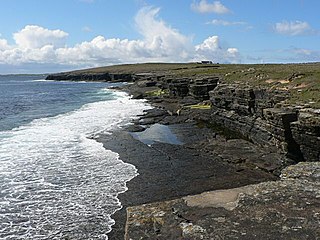
It is a tabular islet with vertical faces about 160 ft (49 m) high, [2] and is adjacent to the Isle of Noss, from which it is separated by a 20 metres (66 ft). gap [1] Both the Holm of Noss, and the adjacent Faedda Ness on Noss are riddled with caves.
The island's other name, "Cradle Holm", comes from a small hoist, or cradle, which used to run between the island and Noss, for around 200 years from the 17th century, to 1864. It was said to be big enough to be able to take one man, and one sheep. [1]
In 1864, the laird's factor, Mr Walker, had the cradle dismantled on the grounds of safety, and had a wall erected on the neighbouring cliff on Noss. The crofter who constructed the original cradle is said to have won his bet, that he could not climb it, but died shortly after constructing the cradle. [1]
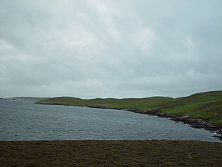
The Isle of Noss or Noss is a small, previously inhabited island in Shetland, Scotland. Noss is separated from the island of Bressay by the narrow Noss Sound. It has been run as a sheep farm since 1900, and has been a national nature reserve since 1955.
Papa Westray, also known as Papay, is one of the Orkney Islands in Scotland, United Kingdom. The fertile soil has long been a draw to the island.

Copinsay is one of the Orkney Islands in Scotland, lying off the east coast of the Orkney Mainland. The smaller companion island to Copinsay, Horse of Copinsay lies to the northeast. The Horse is uninhabited, and is managed as a bird reserve. Copinsay is also home to a lighthouse.

Hildasay, also known as Hildisay, is an uninhabited island off the west coast of the Shetland Mainland.

Hyskeir or Heyskeir is a low-lying rocky islet in the Inner Hebrides, Scotland. The Hyskeir Lighthouse marks the southern entrance to the Minch.

Eilean nan Ròn is an island near Skerray, in the north of Sutherland, Scotland. An estimated 350 seal pups are born here annually.

Glimps Holm or Glims Holm is a small uninhabited islet in Orkney, Scotland.

Muckle Green Holm is an uninhabited island in the North Isles of the Orkney archipelago in Scotland. It is roughly 28 hectares (0.11 sq mi) in extent and rises to 28 metres (92 ft) above sea level, the summit having a trig point.

Damsay is an islet in the Orkney archipelago in Scotland. It is approximately 18 hectares (0.07 sq mi) in extent and rises to only 11 metres (36 ft) above sea level. It is situated in the Bay of Firth north of the Orkney Mainland near Finstown. Nearby is the smaller islet of Holm of Grimbister.
West Linga is an uninhabited island located between Mainland and Whalsay in Shetland, Scotland.

The Holm of Faray is a small island in Orkney, Scotland, near Faray and Westray, which it lies between. Together with its neighbour Faray, it is designated a SSSI due to its importance as a haul-out site and breeding area for grey seals.
Brei Holm is a tiny tidal islet in the western Shetland Islands. It is due east of Papa Stour, to which it is connected at low tide, just outside Housa Voe. It is about a mile off Mainland, Shetland, and not far from the Maiden Stack.

Gloup Holm is an islet in the Shetland Islands, lying to the north of Yell.
Forewick Holm is a 1-hectare (2.5-acre) island in the Sound of Papa in the Shetland islands, Scotland. Located between Papa Stour and the Sandness peninsula. Since 2008, it has also been referred to as Forvik Island as a result of Stuart "Captain Calamity" Hill's protest around constitutional matters.
There are numerous islands containing the word holm, mainly in northern Europe. In many cases the name is derived from the Old Norse holmr, meaning "a small and rounded islet". These include:
Law Ting Holm is a small promontory at the north end of the freshwater Loch of Tingwall, Mainland Shetland, Scotland. It was once an islet entirely surrounded by water, joined to the shore by a stone causeway 1.7 metres (6 ft) wide and 42.7 metres (140 ft) long. In the 1850s the levels of the loch were lowered and the holm evolved to its present form. The Loch of Tingwall is west of the town of Lerwick and has one additional island - Holm of Setter.

Isbister Holm is a small islet in the Shetland islands of Scotland, situated roughly 2 kilometres (1.2 mi) east off the coast of Isbister, Whalsay. The highest point of the islet is about 65 feet (20 m) and it measures roughly 500 metres (1,600 ft) by 250 metres (820 ft). To the north are the islets of Mooa and Nista. On 12 November 1778 Jufron Ingester was shipwrecked, probably on the holm, the precise location not being certain. It was carrying some 260 tons of skins, tallow and coarse hose from Ireland to Copenhagen. One crew member died and the cargo was not salvaged.
Rumble is a skerry in the Shetland islands of Scotland, situated roughly 4 kilometres (2.5 mi) east off the coast of Huxter, southeastern Whalsay. It lies 0.75 miles (1.21 km) to southwest of East Linga. The main island, also known as Rumble Holm, is 27 feet (8.2 m) high. Nearby and to the north are the Flaeshans of Rumble, a series of small islets and stacks and Burlastack of Rumble lies to the east. On the northern side of the main island is an inlet, known as the Voe of Rumble. Lobsters and prawns are said to shelter here. It is also mentioned that a ship named Griften of unknown nationality was shipwrecked either here or on the Holm of Sandwick in 1611.
| Wikimedia Commons has media related to Holm of Noss . |
Coordinates: 60°7′58″N1°0′36″W / 60.13278°N 1.01000°W
| | This Shetland location article is a stub. You can help Wikipedia by expanding it. |