Hoy is an island in Orkney, Scotland, measuring 143 square kilometres (55 sq mi) – the second largest in the archipelago, after Mainland. A natural causeway, the Ayre, links the island to the smaller South Walls; the two islands are treated as one entity by the UK census. Hoy is also the name of a hamlet in the northwest of the island.

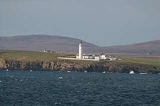
The Brough of Birsay is an uninhabited tidal island off the north-west coast of The Mainland of Orkney, Scotland, in the parish of Birsay. It is located around 13 miles north of Stromness and features the remains of Pictish and Norse settlements as well as a modern lighthouse.

Flotta is a small island in Orkney, Scotland, lying in Scapa Flow. The island is known for its large oil terminal and is linked by Orkney Ferries to Houton on the Orkney Mainland, Lyness on Hoy and Longhope on South Walls. The island has a population of 80.
Burray is one of the Orkney Islands in Scotland. It lies to the east of Scapa Flow and is one of a chain of islands linked by the Churchill Barriers.
Eynhallow is a small, presently uninhabited island in Eynhallow Sound, between Rousay and the Mainland of Orkney, off the north coast of mainland Scotland. It is 75 hectares in area. There is an unnamed skerry about 100 metres to the north-east of the island, separated by Fint Sound. Sheep Skerry adjoins the southern end of the island.
Lamb Holm is a small uninhabited island in Orkney, Scotland. The Italian Chapel, constructed during the Second World War, is the island's main attraction.
Auskerry is a small island in eastern Orkney, Scotland. It lies in the North Sea south of Stronsay and has a lighthouse, completed in 1866.
The Calf of Eday is an uninhabited island in Orkney, Scotland, lying north east of Eday. It is known for its wildlife and its prehistoric ruins.

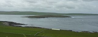
Fara is a small island in Orkney, Scotland, lying in Scapa Flow between the islands of Flotta and Hoy. It has been uninhabited since the 1960s.

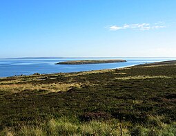
Switha is a small uninhabited island towards the south of Orkney, Scotland, approximately 41 hectares in area.
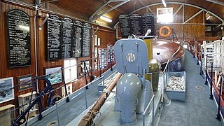
RNLB Thomas McCunn is a 45ft 6in Watson-class lifeboat stationed at Longhope in Orkney, Scotland, from January 1933 until April 1962. During which time she was launched on service 101 times and saved 308 lives. After Thomas McCunn left Longhope she was placed into the reserve fleet for ten years before being sold and used as a pleasure boat. In 2000 she was bought by Longhope Lifeboat Museum. The lifeboat is now at the centre of a display in the old slipway at Brims and is still launched on special occasions.

Gairsay is a small island in Orkney, Scotland, located in the parish of Rendall, 1.5 miles (2.4 km) off the coast, astride one of the approaches to the bays of Firth and Kirkwall. It is about 2 miles (3.2 km) long and 1 mile (1.6 km) wide and includes one conical hill and a small harbour called Millburn Bay, which is sheltered by the peninsula known as the Hen of Gairsay.
South Walls is a tidal island or peninsula at the southern end of Hoy in Orkney, Scotland. It is connected to the main body of Hoy, and to the district of North Walls, by a thin neck of land known as the Ayre. Its largest settlement is Longhope, which lies on a long natural harbour of the same name. Both North and South Walls belong to the civil parish of Walls and Flotta.
There are many small islands in Scotland called Flodday or similar and this list provides a guide to their location. The derivation of the name is from the Old Norse floti meaning "raft" or "float". The similar island names Fladda and Flotta are also from the Norse flatr and mean "flat island". Usage is not always consistent in external sources.
Cava is an uninhabited island in the Orkney archipelago in Scotland. It is 107 hectares (0.41 sq mi) in extent and rises to 38 metres (125 ft) above sea level. The literal meaning of the name is calf island, a terminology often used to designate a small island near to a larger one. Cava is unusual in that it includes a small peninsula joined to the main body of the island by a narrow isthmus, which is in turn called Calf of Cava.

The Barrel of Butter, formerly known as Carlin Skerry, is a skerry in Scapa Flow in the Orkney Islands.

The A961 is a single-carriageway road on the eastern side of Scapa Flow in the Orkney Islands, connecting the town of Kirkwall on the Orkney Mainland to Burwick at the southern end of South Ronaldsay.

Inner Holm is a small inhabited island in Stromness harbour and one of the Orkney islands of Scotland.