
Orkney, also known as the Orkney Islands, is an archipelago in the Northern Isles off the north coast of Scotland. Orkney is 10 miles (16 km) north of Caithness and has about 70 islands, of which 20 are inhabited. The largest island, the Mainland, has an area of 523 square kilometres (202 sq mi), making it the sixth-largest Scottish island and the tenth-largest island in the British Isles. Orkney's largest settlement, and also its administrative centre, is Kirkwall.

Stromness is the second-most populous town in Orkney, Scotland. It is in the southwestern part of Mainland, Orkney. It is a burgh with a parish around the outside with the town of Stromness as its capital.

The Mainland, also known as Hrossey and Pomona, is the main island of Orkney, Scotland. Both of Orkney's burghs, Kirkwall and Stromness, lie on the island, which is also the heart of Orkney's ferry and air connections.

Flotta is a small island in Orkney, Scotland, lying in Scapa Flow. The island is known for its large oil terminal and is linked by Orkney Ferries to Houton on the Orkney Mainland, Lyness on Hoy and Longhope on South Walls. The island has a population of 80.
South Ronaldsay is one of the Orkney Islands off the north coast of Scotland. It is linked to the Orkney Mainland by the Churchill Barriers, running via Burray, Glimps Holm and Lamb Holm.

Graemsay is an island in the western approaches to Scapa Flow, in the Orkney Islands of Scotland. The island has two lighthouses. Graemsay lies within the parish of Stromness.

Robert Smith Candlish was a Scottish minister who was a leading figure in the Disruption of 1843. He served for many years in both St. George's Church and St George's Free Church on Charlotte Square in Edinburgh's New Town.
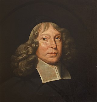
Samuel Rutherford was a Scottish Presbyterian pastor and theologian and one of the Scottish Commissioners to the Westminster Assembly.
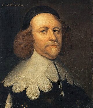
Archibald Johnston, Lord Wariston was a Scottish judge and statesman.

The Hall of Clestrain is a house in the parish of Orphir, Orkney, Scotland. The house was the birthplace of the explorer John Rae in 1813. Currently derelict, the house became a listed building in 1971. It featured in the second series of the BBC TV series Restoration in 2004.

Gills Bay, which is situated about 3 mi (4.8 km) west of John o' Groats with the community of Gills close by, has one of the longest stretches of low-lying rock coast on the northern shores of Caithness. Its main features are a small harbour and the pier used as the mainland terminal for Pentland Ferries. The harbour shelters some small local boats together with those used for working the sheep on the off lying island of Stroma. In the right sea conditions the area is sometimes used for surfing.
Cava is an uninhabited island in the Orkney archipelago in Scotland. It is 107 hectares (0.41 sq mi) in extent and rises to 38 metres (125 ft) above sea level. The literal meaning of the name is calf island, a terminology often used to designate a small island near to a larger one. Cava is unusual in that it includes a small peninsula joined to the main body of the island by a narrow isthmus, which is in turn called Calf of Cava.

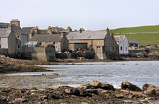
Houton is a settlement 5 miles (8.0 km) southeast of Stromness on the island of Mainland, Orkney, Scotland. The settlement is within the parish of Orphir, and is situated on a minor road off the A964.

The Holm of Houton is one of the southern Orkney islands.
Margaret Moyes Black was a Scottish novelist and biographer. She was born on 27 April 1853 in the parish of Scoonie, Fife. Her father was William Black, a shipmaster, and her mother was Margaret Moyes Deas. She wrote her first novel, In Glenoran, under the pseudonym of M.B. Fife. Of the volume on Robert Louis Stevenson, in the Famous Scots Series, Black stated in her preface that it is, "only a reminiscence and an appreciation by one who, in the old days between 1869 and 1880, knew him and his home circle well." She was unmarried and died on 16 October 1935 at Montrose, Angus.

Colonel Henry Halcro Johnston CB CBE DL FRSE FLS was a Scottish botanist, physician, rugby union international and Deputy Lieutenant for Orkney. As a member of Edinburgh University RFC he represented Scotland in 1877 and went on to make a significant contribution to botany and horticulture through his meticulous collection and recording of plant species during and after his distinguished military career.

David Hackston or Halkerstone, was a militant Scottish Covenanter, remembered mainly for his part in the murder of Archbishop James Sharp of St. Andrews in 1679 and his involvement in the events of 1680 which led to his capture and execution.

The remains of the Orphir Round Church, also St Nicholas's Church, are located in Orphir Parish on the Mainland, Orkney, Scotland. It has been part of a scheduled monument since 2014.
Margaret Manson Graham was a Scottish nurse who worked as a missionary in Nigeria.
This article incorporates text from - Wilson, Rev. John The Gazetteer of Scotland (Edinburgh, 1882) Published by W. & A.K. Johnstone
