Broughtown

Last updated

Broughtown
Sanday Parish Church near Broughtown (geograph 1899006).jpg
Sanday Parish Church, Broughtown
Orkney Islands UK location map.svg
Red pog.svg
Broughtown
Location within Orkney
OS grid reference HY659410
Civil parish
Council area
Lieutenancy area
Country Scotland
Sovereign state United Kingdom
Post town ORKNEY
Postcode district KW17
Dialling code 01856
Police Scotland
Fire Scottish
Ambulance Scottish
UK Parliament
Scottish Parliament
List of places
UK
Scotland
59°15′18″N2°35′53″W / 59.255°N 2.598°W / 59.255; -2.598

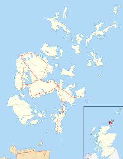
Broughtown is a village on the island of Sanday, in Orkney, Scotland. The settlement is within the parish of Cross and Burness. [1] Sanday Airport is adjacent to the eastern side of the village and Kettletoft is to the south. The B9068 road runs south to north, through Broughtown, connecting Kettletoft with Scar. Meanwhile, the B9070 road runs south-west from Broughtown, and south beyond Braeswick, to the Sanday ferry terminal at Spur Ness. [2]
Related Research Articles

<span class="mw-page-title-main">Small Isles</span> Island group off the west coast of Scotland

The Small Isles are a small archipelago of islands in the Inner Hebrides, off the west coast of Scotland. They lie south of Skye and north of Mull and Ardnamurchan – the most westerly point of mainland Scotland.

<span class="mw-page-title-main">Canna, Scotland</span> Island in the Inner Hebrides

Canna is the westernmost of the Small Isles archipelago, in the Scottish Inner Hebrides. It is linked to the neighbouring island of Sanday by a road and sandbanks at low tide. The island is 4.3 miles (6.9 km) long and 1 mile (1.6 km) wide. The isolated skerries of Hyskeir and Humla lie 6.2 miles (10.0 km) south-west of the island.

<span class="mw-page-title-main">Sanday, Orkney</span> Island in Orkney, Scotland

Sanday is one of the inhabited islands of Orkney that lies off the north coast of mainland Scotland. With an area of 50.43 km2 (19.5 sq mi), it is the third largest of the Orkney Islands. The main centres of population are Lady Village and Kettletoft. Sanday can be reached by Orkney Ferries or by plane from Kirkwall on the Orkney Mainland. On Sanday, an on-demand public minibus service allows connecting to the ferry.

<span class="mw-page-title-main">Stoke-by-Nayland</span> Human settlement in England

Stoke-by-Nayland is a village and civil parish in the Babergh district, in the county of Suffolk, England, close to the border with Essex. The parish includes the village of Withermarsh Green and the hamlets of Thorington Street and Scotland Street. The village has many cottages and timber-framed houses, all surrounding a recreation field. Possibly once the site of a monastery, the population of the civil parish was 703 at the 2001 Census, falling to 682 at the 2011 Census.

<span class="mw-page-title-main">Dreghorn</span> Human settlement in Scotland

Dreghorn is a village in North Ayrshire, Scotland, 3.5 kilometres east of Irvine town centre, on the old main road from Irvine to Kilmarnock. It is sited on a ridge between two rivers. As archaeological excavations near the village centre have found a significant neolithic settlement provisionally dated to around 3500 BC, as well as medieval structures, scholars have suggested that Dreghorn could be Britain's oldest continuously inhabited village. Both Irvine and Dreghorn have grown in size and they are now separated by the Annick Valley Park, which incorporates a footpath and National Cycle Route 73 on the route of the disused Irvine to Busby railway line. It had an estimated population of 3,450 in 2020.

<span class="mw-page-title-main">Woolhampton</span> Village and civil parish in England

Woolhampton is a village and civil parish in West Berkshire, England. The village straddles the Bath Road between the towns of Reading, 8 mi (13 km) to the east, and Newbury, 6 mi (10 km) to the west.

<span class="mw-page-title-main">Gardenstown</span> Human settlement in Scotland

Gardenstown is a small coastal village, 8.7 miles (14.0 km) by road east of Banff in Aberdeenshire, northeastern Scotland.

<span class="mw-page-title-main">Liff, Angus</span> Human settlement in Scotland

Liff is a village in Angus, Scotland, situated 4+12 miles west-northwest of Dundee on a south-facing slope two miles north of the River Tay. It had a population of 568 in 2011.

<span class="mw-page-title-main">Bishop of Orkney</span> Head of the Scottish diocese, c. 1035–1688

The Bishop of Orkney was the ecclesiastical head of the Diocese of Orkney, one of thirteen medieval bishoprics of Scotland. It included both Orkney and Shetland. It was based for almost all of its history at St Magnus Cathedral, Kirkwall.

<span class="mw-page-title-main">A146 road</span> A road in East Anglia, England

The A146 is an A road that connects Norwich in Norfolk and Lowestoft in Suffolk, two of East Anglia's largest population centres. It is around 27 miles (43 km) in length and has primary classification along its entire route. It is mainly single carriageway throughout its route, with the exception of a section of dual carriageway on the southern edge of Norwich.

<span class="mw-page-title-main">Meikleour</span> Village in Perth and Kinross, Scotland, UK

Meikleour is a village in Perth and Kinross, Scotland. It lies near the confluence of the Tay and the Isla in the valley of Strathmore, 12 miles (19 km) north of Perth and 4 miles (6.4 km) south of Blairgowrie. It is in the parish of Caputh.

<span class="mw-page-title-main">Braeswick</span> Human settlement in Scotland

Braeswick is a settlement on the island of Sanday, in Orkney, Scotland. The settlement is within the parish of Cross and Burness, and is situated on the B9070.

<span class="mw-page-title-main">Bustatoun</span> Human settlement in Scotland

Bustatoun is a village on the island of North Ronaldsay, in Orkney, Scotland. The settlement is within the parish of Cross and Burness.

<span class="mw-page-title-main">A144 road</span> Road in Suffolk, England

The A144 is an A road in the English county of Suffolk. It runs from the town of Bungay, close to the border with Norfolk, to the A12 trunk road near the village of Darsham, passing through the market town of Halesworth. It is around 14 miles (23 km) in length and is single carriageway throughout.

<span class="mw-page-title-main">Kettletoft</span>

Kettletoft is a settlement on the island of Sanday in Orkney, Scotland. The B9068 road runs from Kettletoft to Scar and the B9069 from Kettletoft to Northwall. Kettletoft pier, including the slipway, is a B listed building and was inscribed on 16 September 1999.

<span class="mw-page-title-main">Scar, Orkney</span> Village in Scotland

Scar is a village and farm complex on the island of Sanday in Orkney, Scotland. The B9068 road runs from Scar to Kettletoft. The Scar boat burial was found at the Crook Beach in 1985 and discovered in September 1991. Scar House, former windmill and former water mill are B listed buildings.

Robert Howie Fisher (1861–1934) was a Scottish minister in the 19th century who became Chaplain in Ordinary to King George V in Scotland from 1913.

References

  1. "Details of Parish of Cross and Burness". Gazetteer for Scotland . Retrieved 1 January 2015.
  2. "B9070". Sabre. Retrieved 1 January 2015.