
Hoy is an island in Orkney, Scotland, measuring 143 square kilometres (55 sq mi) – the second largest in the archipelago, after Mainland. A natural causeway, the Ayre, links the island to the smaller South Walls; the two islands are treated as one entity by the UK census. Hoy is also the name of a hamlet in the northwest of the island.
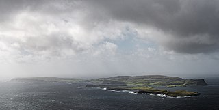
Canna is the westernmost of the Small Isles archipelago, in the Scottish Inner Hebrides. It is linked to the neighbouring island of Sanday by a road and sandbanks at low tide. The island is 4.3 miles (6.9 km) long and 1 mile (1.6 km) wide. The isolated skerries of Hyskeir and Humla lie 6.2 miles (10.0 km) south-west of the island.

Sanday is one of the Small Isles, in the Scottish Inner Hebrides. It is a tidal island linked to its larger neighbour, Canna, via sandbanks at low tide, and also connected to the larger island by a bridge. Canna and Sanday form a single community, and are usually described as Canna.

Sanday is one of the inhabited islands of Orkney that lies off the north coast of mainland Scotland. With an area of 50.43 km2 (19.5 sq mi), it is the third largest of the Orkney Islands. The main centres of population are Lady Village and Kettletoft. Sanday can be reached by Orkney Ferries or by plane from Kirkwall on the Orkney Mainland. On Sanday, an on-demand public minibus service allows connecting to the ferry.

Stronsay is an island in Orkney, Scotland. It is known as Orkney's 'Island of Bays', owing to an irregular shape with miles of coastline, with three large bays separated by two isthmuses: St Catherine's Bay to the west, the Bay of Holland to the south and Mill Bay to the east. Stronsay is 3,275 hectares in area, and 44 metres in altitude at its highest point. It has a usually resident population of 349. The main village is Whitehall, home to a heritage centre.
Westray is one of the Orkney Islands in Scotland, with a usual resident population of just under 600 people. Its main village is Pierowall, with a heritage centre, the 15th-century Lady Kirk church and pedestrian ferry service to nearby Papa Westray island. Westray has a number of archeological sites dating from 3500 BC, and remains of several Norse-Viking settlements. The spectacular sea cliffs around Noup Head are home to thousands of seabirds.

PS Maid of the Loch is the last paddle steamer built in the United Kingdom. She operated on Loch Lomond for 29 years and as of 2022 is being restored near Balloch pier.

Balloch is a village in West Dunbartonshire, Scotland, at the foot of Loch Lomond.

Old Scatness is an archeological site on Scat Ness, near the village of Scatness, in the parish of Dunrossness in the south end of Mainland, Shetland, Scotland, near Sumburgh Airport. It consists of medieval, Viking, Pictish, and Iron Age remains and has been a settlement for thousands of years, each new generation adding buildings, and levelling off old ones. Among the discoveries is an Iron Age broch, the Ness of Burgi fort.

The Sanday Light Railway was a privately owned ridable miniature railway situated in Braeswick, on the island of Sanday, Orkney, Scotland.

Langston was a small station on the Hayling Island branch. The station along with the rest of the line closed in 1963, and it served the Langstone area of Havant, a former village which had become contiguous with the larger town to its north. The railway companies always used the old spelling "Langston" for the station, in spite of this form not being used by the local community, and it can be seen in many photographs of the station sign.

The Underfall Yard is a historic boatyard on Spike Island serving Bristol Harbour in England.

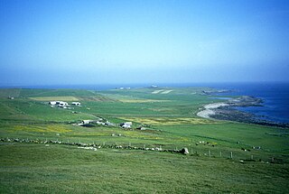
Broughtown is a village on the island of Sanday, in Orkney, Scotland. The settlement is within the parish of Cross and Burness. Sanday Airport is adjacent to the eastern side of the village and Kettletoft is to the south. The B9068 road runs south to north, through Broughtown, connecting Kettletoft with Scar. Meanwhile, the B9070 road runs south-west from Broughtown, and south beyond Braeswick, to the Sanday ferry terminal at Spur Ness.

Glasson Dock, also known as Glasson, is a village in Lancashire, England, south of Lancaster at the mouth of the River Lune. In 2011, it had a population of around 600.

Ardvourlie Castle is a 19th-century country house on Harris, one of the Western Isles off the north-west coast of Scotland. The house was built beside Loch Seaforth in 1863 as a hunting lodge on the North Harris Estate, for Charles Murray, 7th Earl of Dunmore, the then owner of the island. It is a category B listed building.
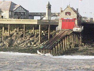
Weston-super-Mare Lifeboat Station is a lifeboat station at Weston-super-Mare in Somerset, England. For more than 100 years it was situated on Birnbeck Island but is now in a temporary building at Knightstone Harbour until a new lifeboat station can be built nearby. It is operated by the Royal National Lifeboat Institution (RNLI). The first lifeboat was stationed in the town in 1882, and since 1969 it has only operated inshore lifeboats (ILBs), currently a B-class and a smaller D-class (IB1).

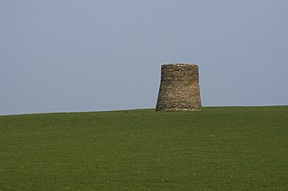
Torthorwald is a village and civil parish in Dumfries and Galloway, south-west Scotland. It is located 6 kilometres (3.7 mi) east of Dumfries on the A709 road to Lochmaben. The area was the property of the de Torthorwald family until the end of the 13th century, when the estate passed by marriage to the Kirkpatricks. In 1418, William de Carleil married the Kirkpatrick heiress. He may have been the builder of Torthorwald Castle, which was erected around this time, possibly on top of an earlier a motte. Torthorwald was erected as a burgh of barony in 1473. Torthorwald Castle was occupied until 1715; only two of its walls still stand, to a height of around 18 metres (59 ft).

The Scar boat burial is a Viking boat burial near the village of Scar, on Sanday, in Orkney, Scotland. The burial, which dates to between 875 and 950 AD, contained the remains of a man, an elderly woman, and a child, along with numerous grave goods. Although the site had to be excavated quickly because of the threat of coastal erosion owing to bad weather conditions, it yielded many important finds.
Scar is a village and farm complex on the island of Sanday in Orkney, Scotland. The B9068 road runs from Scar to Kettletoft. The Scar boat burial was found at the Crook Beach in 1985 and discovered in September 1991. Scar House, former windmill and former water mill are B listed buildings.
