Bustatoun

Last updated

Bustatoun
Burrian Broch, North Ronaldsay - geograph.org.uk - 33811.jpg
Burrian Broch, at the south of the settlement
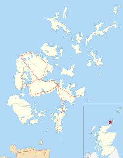
Orkney Islands UK location map.svg
Red pog.svg
Bustatoun
Location within Orkney
OS grid reference HY760521
Civil parish
  • Cross and Burness
Council area
Lieutenancy area
Country Scotland
Sovereign state United Kingdom
Post town ORKNEY
Postcode district KW17
Dialling code 01856
Police Scotland
Fire Scottish
Ambulance Scottish
UK Parliament
Scottish Parliament
List of places
UK
Scotland
59°21′18″N2°25′16″W / 59.355°N 2.421°W / 59.355; -2.421

Bustatoun is a village on the island of North Ronaldsay, in Orkney, Scotland. The settlement is within the parish of Cross and Burness. [1]
Related Research Articles

<span class="mw-page-title-main">Orkney</span> Archipelago, county and council area in northern Scotland

Orkney, also known as the Orkney Islands, is an archipelago in the Northern Isles off the north coast of Scotland. Orkney is 10 miles (16 km) north of Caithness and has about 70 islands, of which 20 are inhabited. The largest island, the Mainland, has an area of 523 square kilometres (202 sq mi), making it the sixth-largest Scottish island and the tenth-largest island in the British Isles. Orkney's largest settlement, and also its administrative centre, is Kirkwall.

<span class="mw-page-title-main">Stromness</span> Human settlement in Scotland

Stromness is the second-most populous town in Orkney, Scotland. It is in the southwestern part of Mainland, Orkney. It is a burgh with a parish around the outside with the town of Stromness as its capital.

Dean Village is a former village immediately northwest of the city centre of Edinburgh, Scotland. It is bounded by Belford Road to the south and west, Belgrave Crescent Gardens to the north and below the Dean Bridge to the east. It was formerly known as the "Water of Leith Village" and was a successful grain milling area for more than 800 years. At one time there were no fewer than eleven working mills there, driven by water from the Water of Leith.

<span class="mw-page-title-main">Mainland, Orkney</span> Main island of the Orkney Islands, Scotland

The Mainland, also known as Hrossey and Pomona, is the main island of Orkney, Scotland. Both of Orkney's burghs, Kirkwall and Stromness, lie on the island, which is also the heart of Orkney's ferry and air connections.

<span class="mw-page-title-main">South Ronaldsay</span> Island in southeast Orkney, Scotland, UK

South Ronaldsay is one of the Orkney Islands off the north coast of Scotland. It is linked to the Orkney Mainland by the Churchill Barriers, running via Burray, Glimps Holm and Lamb Holm.

<span class="mw-page-title-main">North Ronaldsay</span> Island in Scotland

North Ronaldsay is the northernmost island in the Orkney archipelago of Scotland. With an area of 690 hectares (2.7 sq mi), it is the fourteenth-largest. It is mentioned in the Orkneyinga saga; in modern times it is known for its historic lighthouse, migratory bird life and unusual breed of sheep.

<span class="mw-page-title-main">North Ronaldsay sheep</span> Breed of sheep from Scotland

The North Ronaldsay or Orkney is a breed of sheep from North Ronaldsay, the northernmost island of Orkney, off the north coast of Scotland. It belongs to the Northern European short-tailed sheep group of breeds, and has evolved without much cross-breeding with modern breeds. It is a smaller sheep than most, with the rams (males) horned and ewes (females) mostly hornless. It was formerly kept primarily for wool, but now the two largest flocks are feral, one on North Ronaldsay and another on the Orkney island of Auskerry. The Rare Breeds Survival Trust lists the breed as a priority on its 2021–2022 watchlist, and they are in danger of extinction, with fewer than 600 registered breeding females in the United Kingdom.

<span class="mw-page-title-main">Unstan ware</span> Type of pottery

Unstan ware is the name used by archaeologists for a type of finely made and decorated Neolithic pottery from the 4th and 3rd millennia BC. Typical are elegant and distinctive shallow bowls with a band of grooved patterning below the rim, a type of decoration which was created using a technique known as "stab-and-drag". A second version consists of undecorated, round-bottomed bowls. Some of the bowls had bits of volcanic rock included in the clay to make them stronger. Bone tools were used to burnish the surfaces to make them shiny and impermeable.

The MV Braer was an oil tanker which ran aground during a storm off Shetland, Scotland, in January 1993, and nearly a week later broke up during the most intense extratropical cyclone on record for the northern Atlantic Ocean, the Braer Storm of January 1993.

<span class="mw-page-title-main">Bishop of Orkney</span> Head of the Scottish diocese, c. 1035–1688

The Bishop of Orkney was the ecclesiastical head of the Diocese of Orkney, one of thirteen medieval bishoprics of Scotland. It included both Orkney and Shetland. It was based for almost all of its history at St Magnus Cathedral, Kirkwall.

<span class="mw-page-title-main">Churchill Barriers</span> Four causeways in Orkney, Scotland

The Churchill Barriers are four causeways in the Orkney islands with a total length of 2.3 kilometres (1.4 mi). They link the Orkney Mainland in the north to the island of South Ronaldsay via Burray and the two smaller islands of Lamb Holm and Glimps Holm.

<span class="mw-page-title-main">North Ronaldsay Airport</span> Airport

North Ronaldsay Airport is located on North Ronaldsay island, 28 NM northeast by north of Kirkwall, Orkney Islands, Scotland.

<span class="mw-page-title-main">Dennis Head Old Beacon</span> Lighthouse

Dennis Head Old Beacon is a ruined lighthouse on the island of North Ronaldsay, Orkney, Scotland. The beacon and keepers' houses are protected as a scheduled monument.

<span class="mw-page-title-main">Ancumtoun</span> Human settlement in Scotland

Ancumtoun is a small settlement in the north of the island of North Ronaldsay, Orkney, Scotland. The settlement is within the parish of Cross and Burness.

<span class="mw-page-title-main">Orkney Islands Council</span> Local authority for Orkney, Scotland

The Orkney Islands Council, is the local authority for Orkney, Scotland. It was established in 1975 by the Local Government (Scotland) Act 1973 and was largely unaffected by the Scottish local government changes of the mid-1990s.

<span class="mw-page-title-main">Delting</span> Scottish parish

Delting is a civil parish and community council area on Mainland, Shetland, Scotland. It includes the Sullom Voe oil terminal and its main settlements are Brae, Mossbank and Voe.

<span class="mw-page-title-main">Broch of Burrian</span>

The Broch of Burrian is an Iron Age broch located on North Ronaldsay in the Orkney Islands, in Scotland.

<span class="mw-page-title-main">North Ronaldsay Lighthouse</span> Lighthouse

North Ronaldsay Lighthouse was built in 1852 on the island of North Ronaldsay in the Orkney Islands, Scotland, 43 years after Dennis Head Old Beacon was deactivated. It lies at the north of the island at Point of Sinsoss , and boasts Britain's tallest land-based lighthouse tower. The old fog siren with notable red trumpet was replaced by an electric diaphragm-type horn. That horn was discontinued in favour of a Tyfon horn consisting of 8 mini-trumpets installed on the building that once housed the fog siren. The Tyfon horn gives three blasts every 60 seconds. The electric beeper horn now lies flat on the ground next to the fog signal building, and is still in service today.

<span class="mw-page-title-main">2022 Orkney Islands Council election</span> Orkney Islands Council election

Elections to the Orkney Islands Council were held on 5 May 2022, the same day as the 31 other Scottish local government elections. The election used the six wards created under the Local Governance (Scotland) Act 2004, with 21 councillors being elected. Each ward elected either 3 or 4 members, using the STV electoral system.

References

  1. "Details of Bustatoun". Gazetteer for Scotland . Retrieved 1 January 2015.