Toab, Orkney

Last updated

Toab
Toab, the post office - geograph.org.uk - 2609808.jpg
The former Toab shop and petrol station in 2011.
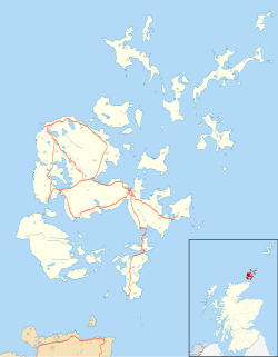
Orkney Islands UK location map.svg
Red pog.svg
Toab
Location within Orkney
OS grid reference HY510069
Civil parish
Council area
Lieutenancy area
Country Scotland
Sovereign state United Kingdom
Post town ORKNEY
Postcode district KW17
Dialling code 01856
Police Scotland
Fire Scottish
Ambulance Scottish
UK Parliament
Scottish Parliament
List of places
UK
Scotland
58°55′23″N2°50′06″W / 58.923°N 2.835°W / 58.923; -2.835

Toab is a village on the Orkney Mainland, situated in the East Mainland, off the A960 road, at the head of Deer Sound.

Contents

St Andrews Primary School is located in Toab, and serves the parishes of Holm, St Andrews, and Deerness. It is thought the name derives from the Norse word Tollhóp, meaning a place where visiting ships had to pay a toll. [1]

People from Toab are known as ‘Toaboggans’, although this term is almost never used.

Both the districts of Toab and nearby Tankerness are often mistakenly referred to as parishes, although they both come under the civil parish of St Andrews.

See also

Related Research Articles

<span class="mw-page-title-main">Orkney</span> Archipelago, county and council area in northern Scotland

Orkney, also known as the Orkney Islands, is an archipelago in the Northern Isles of Scotland, situated off the north coast of the island of Great Britain. Orkney is 10 miles (16 km) north of the coast of Caithness and has about 70 islands, of which 20 are inhabited. The largest island, the Mainland, has an area of 523 square kilometres (202 sq mi), making it the sixth-largest Scottish island and the tenth-largest island in the British Isles. Orkney's largest settlement, and also its administrative centre, is Kirkwall.

<span class="mw-page-title-main">Brough of Birsay</span> An uninhabited tidal island off the north-west coast of The Mainland of Orkney, Scotland

The Brough of Birsay is an uninhabited tidal island off the north-west coast of The Mainland of Orkney, Scotland, in the parish of Birsay. It is located around 13 miles north of Stromness and features the remains of Pictish and Norse settlements as well as a modern light house.

<span class="mw-page-title-main">Mainland, Orkney</span> Main island of the Orkney Islands, Scotland

The Mainland, also known as Hrossey and Pomona, is the main island of Orkney, Scotland. Both of Orkney's burghs, Kirkwall and Stromness, lie on the island, which is also the heart of Orkney's ferry and air connections.

<span class="mw-page-title-main">South Ronaldsay</span> Island in southeast Orkney, Scotland, UK

South Ronaldsay is one of the Orkney Islands off the north coast of Scotland. It is linked to the Orkney Mainland by the Churchill Barriers, running via Burray, Glimps Holm and Lamb Holm.

<span class="mw-page-title-main">Birsay</span> Parish on the Orkney mainland

Birsay is a parish in the north west corner of The Mainland of Orkney, Scotland. Almost all the land in the parish is devoted to agriculture: chiefly grassland used to rear beef cattle. There are various ancient monuments in the parish.

<span class="mw-page-title-main">Bishop of Orkney</span> Head of the Scottish diocese, c. 1035–1688

The Bishop of Orkney was the ecclesiastical head of the Diocese of Orkney, one of thirteen medieval bishoprics of Scotland. It included both Orkney and Shetland. It was based for almost all of its history at St Magnus Cathedral, Kirkwall.

Andrew Bruce (c.1630–1699) was a 17th-century Scottish churchman who served as both Protestant Bishop of Dunkeld and Protestant Bishop of Orkney.

<span class="mw-page-title-main">Toab, Shetland</span> Human settlement in Scotland

Toab is the southernmost village on Mainland, Shetland, Scotland. It is part of Virkie and overlooks Sumburgh Airport. Toab is within the parish of Dunrossness.

<span class="mw-page-title-main">Deerness</span> Part of Orkney, Scotland

Deerness is a quoad sacra parish and peninsula in Mainland, Orkney, Scotland. It is about 13.5 kilometres (8.4 mi) south east of Kirkwall. Deerness forms a part of the civil parish of St. Andrews and Deerness. There is a shop/post office and a community centre and the Deerness Distillery.

<span class="mw-page-title-main">Holm, Orkney</span>

Holm, also spelled Ham, is a parish on Mainland, Orkney.

<span class="mw-page-title-main">St Ola</span>

St Ola is a parish on Mainland, Orkney. It is in the centre of the island, east of the parish Firth and north of Holm. It contains the capital and largest town of the Orkney archipelago, Kirkwall. Both Kirkwall and St Ola may take their name from the church of St. Olaf, built about 1035 on the north bank of the Willow burn, which stands just below the local primary school.

<span class="mw-page-title-main">St Andrews, Orkney</span> Human settlement in the Orkney Islands, United Kingdom

St Andrews is a parish on Mainland, Orkney in Scotland. It is located east of the town of Kirkwall and the parish of St Ola and lies north of Holm and west of Deerness. The settlements of Tankerness, Toab and Foubister are in the parish, as is Kirkwall Airport.

<span class="mw-page-title-main">Sandwick, Orkney</span> Parish on Orkney

Sandwick is a parish on the west coast of Mainland, Orkney, Scotland, 4 miles (6.4 km) north of Stromness.

<span class="mw-page-title-main">Tankerness</span> Human settlement in Scotland

Tankerness is a district in the St Andrews parish in Mainland, Orkney, Scotland. Essentially a peninsula, it is about 13 kilometres (8 mi) south-east of Kirkwall and 1 kilometre (0.6 mi) east of Kirkwall Airport. The origin of the place name is uncertain, but it may derive from the Norse personal name "Tannskári". A "ness" is a promontory.

<span class="mw-page-title-main">The Gloup</span>

The Gloup is a collapsed sea cave in the Mull Head Nature Reserve in the islands of Orkney, Scotland.

Broch of Ayre, also known as St. Mary's Broch, is an Iron Age broch in Orkney, Scotland.

References

  1. "Orkney Placenames". Orkneyjar. Retrieved 27 May 2008.