KW postcode area

Last updated

Template:Attached KML/KW postcode area
KML is from Wikidata
Kirkwall
United Kingdom adm location map.svg
Red pog.svg
KW
Coordinates: 58°39′14″N3°17′20″W / 58.654°N 3.289°W / 58.654; -3.289
CountryUnited Kingdom
Postcode area
KW
Postcode area name
Kirkwall
Post towns 15
Postcode districts 16
Postcode sectors22
Postcodes (live)1,835
Postcodes (total)2,103
Statistics as at May 2020 [1]

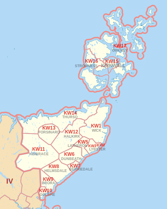
The KW postcode area, also known as the Kirkwall postcode area, is a group of sixteen postcode districts in the far north of Scotland, within fifteen post towns. These cover Caithness (including Wick, Thurso, Halkirk, Berriedale, Dunbeath, Latheron and Lybster), east Sutherland (including Golspie, Brora, Helmsdale, Kinbrace and Forsinard) and the Orkney Islands.

Contents

Mail for the KW postcode area is processed at Inverness Mail Centre, along with mail for the IV and HS postcode areas.

Coverage

The approximate coverage of the postcode districts:

Postcode district Post town CoverageLocal authority area(s)
KW1WICK Wick, John o' Groats, Keiss Highland
KW2LYBSTER Ulbster, Whaligoe, Bruan Highland
KW3LYBSTER Lybster, Clyth Highland
KW5LATHERON Latheron, Latheronwheel Highland
KW6DUNBEATH Dunbeath Highland
KW7BERRIEDALE Berriedale, Newport Highland
KW8HELMSDALE Helmsdale Highland
KW9BRORA Brora Highland
KW10GOLSPIE Golspie Highland
KW11KINBRACE Kinbrace Highland
KW12HALKIRK Halkirk, Georgemas, Westerdale Highland
KW13FORSINARD Forsinard, Achiemore Highland
KW14THURSO Thurso, Scrabster, Castletown, Dunnet, Mey, Melvich, Strathy, Bettyhill, Skerray Highland
KW15KIRKWALL Kirkwall, St Ola Orkney Islands
KW16STROMNESS Stromness, Hoy, Flotta, Graemsay, Sandwick, Stenness Orkney Islands
KW17ORKNEYMost of Mainland, all of the north isles, Burray, South Ronaldsay Orkney Islands

Map

Template:Attached KML/KW postcode area
KML is from Wikidata
KW postcode area map, showing postcode districts in red and post towns in grey text, with link to nearby IV postcode area. KW postcode area map.svg
KW postcode area map, showing postcode districts in red and post towns in grey text, with link to nearby IV postcode area.

See also

References

  1. "ONS Postcode Directory Version Notes" (ZIP). National Statistics Postcode Products. Office for National Statistics. May 2020. Table 2. Retrieved 19 June 2020. Coordinates from mean of unit postcode points, "Code-Point Open". OS OpenData. Ordnance Survey. February 2012. Retrieved 21 April 2012.