| Postcode district | Post town | Coverage | Local authority area(s) |
|---|
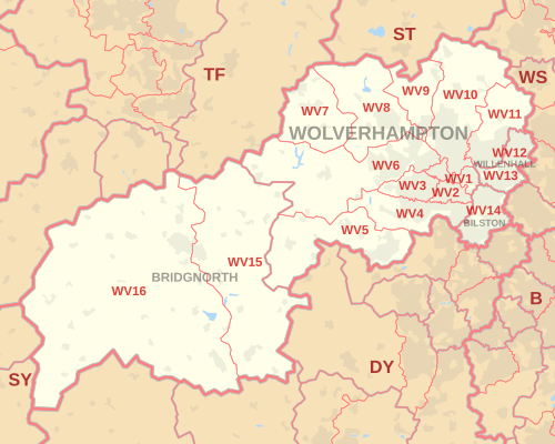
| WV1 | WOLVERHAMPTON | Wolverhampton City Centre, Horseley Fields, East Park | Wolverhampton |
|---|
| WV1 | WILLENHALL | PO Boxes | non-geographic [3] [4] |
|---|
| WV2 | WOLVERHAMPTON | All Saints, Blakenhall, Parkfields | Wolverhampton |
|---|
| WV3 | WOLVERHAMPTON | Finchfield, Compton, Castlecroft | Wolverhampton |
|---|
| WV4 | WOLVERHAMPTON | Penn, Warstones, Merry Hill, parts of Goldthorn Park and Parkfields | Wolverhampton, South Staffordshire |
|---|
| WV5 | WOLVERHAMPTON | Wombourne, Claverley | South Staffordshire, Shropshire |
|---|
| WV6 | WOLVERHAMPTON | Whitmore Reans, Perton, Pattingham, Tettenhall, Ackleton | Wolverhampton, South Staffordshire, Shropshire |
|---|
| WV7 | WOLVERHAMPTON | Albrighton | Shropshire, South Staffordshire |
|---|
| WV8 | WOLVERHAMPTON | Codsall, Rakegate, Bilbrook, Pendeford (west) | South Staffordshire, Shropshire, Wolverhampton |
|---|
| WV9 | WOLVERHAMPTON | Aldersley, Pendeford, Coven | Wolverhampton, South Staffordshire |
|---|
| WV10 | WOLVERHAMPTON | Low Hill, Bushbury, Heath Town, Fordhouses, Fallings Park, Featherstone, Shareshill, parts of Wednesfield and Brinsford | Wolverhampton, South Staffordshire |
|---|
| WV11 | WOLVERHAMPTON | Wednesfield, Ashmore Park, Essington | Wolverhampton, South Staffordshire |
|---|
| WV12 | WILLENHALL | Short Heath, Lodge Farm | Walsall, Wolverhampton |
|---|
| WV13 | WILLENHALL | Willenhall Town, Shepwell Green | Walsall, Wolverhampton |
|---|
| WV14 | BILSTON | Bradley, Bilston Town, Coseley | Wolverhampton (Bilston), Dudley (Coseley), Walsall (Moxley, Bradley), Sandwell (Batman’s hill) |
|---|
| WV15 | BRIDGNORTH | Bridgnorth (Low Town) | Shropshire |
|---|
| WV16 | BRIDGNORTH | Bridgnorth (High Town), Ditton Priors | Shropshire |
|---|
| WV98 | WOLVERHAMPTON | Jobcentre Plus | non-geographic |
|---|
| WV99 | WOLVERHAMPTON | Jobcentre Plus | non-geographic |
|---|