
Dudley is a market town in the West Midlands, England, 6 miles (9.7 km) southeast of Wolverhampton and 8 miles (13 km) northwest of Birmingham. Historically part of Worcestershire, the town is the administrative centre of the Metropolitan Borough of Dudley. In the 2011 census, it had a population of 79,379. The Metropolitan Borough, which includes the towns of Stourbridge and Halesowen, had a population of 312,900. In 2014, the borough council adopted a slogan describing Dudley as the capital of the Black Country, a title by which it had long been informally known.
Tipton is an industrial town in the Metropolitan Borough of Sandwell in the West Midlands County in England. It had a population of 38,777 at the 2011 UK Census. It is located northwest of Birmingham and southeast of Wolverhampton. It is also contiguous with nearby towns of Darlaston, Dudley, Wednesbury and Bilston.

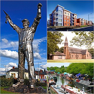
Wednesbury is a market town in Sandwell in the West Midlands County, England - historically in Staffordshire. It is located near the source of the River Tame, and is part of the Black Country. Wednesbury is situated 5 miles (8km) south-east of Wolverhampton, 2.7 miles (4.4km) south-west of Walsall, and 7.3 miles (11.8km) north-west of Birmingham. At the 2011 Census the town had a population of 37,817.

Aldridge is a town and civil parish in the Walsall borough, West Midlands, England. It is historically a village that was part of Staffordshire until 1974. The town is 3 miles (4.8 km) from Brownhills, 5 miles (8 km) from Walsall, 6 miles (9.7 km) from Sutton Coldfield and 7 miles (11 km) from Lichfield. The town is also the second-largest town in the Walsall Borough.
Brownhills is a town in the Metropolitan Borough of Walsall, West Midlands, England. A few miles south of Cannock Chase and close to the large Chasewater reservoir, it is 6 miles (9.7 km) northeast of Walsall, a similar distance southwest of Lichfield and 13 miles (20.9 km) miles north-northwest of Birmingham. It is part of the Aldridge-Brownhills parliamentary constituency and neighbours the large suburban villages of Pelsall and Walsall Wood. It lies within the boundaries of the historic county of Staffordshire.
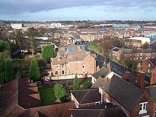
Sedgley is a town in the north of the Metropolitan Borough of Dudley, in the West Midlands, England.

Darlaston is an industrial town in the Metropolitan Borough of Walsall in the West Midlands of England. It is located near Wednesbury and Willenhall.

Ashmore Park is a large housing estate in Wednesfield, England. It has been part of the city of Wolverhampton, West Midlands since 1966, when the majority of Wednesfield was incorporated into Wolverhampton. It forms part of the Wednesfield North ward of the City of Wolverhampton council. The estate consists predominantly of council-built houses, flats and bungalows from the 1950s.

Penn is an area which is divided between the City of Wolverhampton and South Staffordshire district. The population of the Wolverhampton Ward taken at the 2011 census was 12,718. Originally, it was a village in the historic county of Staffordshire. There is considerable confusion about exactly which areas fall within Penn. In 19th century censuses, Merry Hill, Bradmore are understood to form part of Penn, although these areas are generally understood to be separate today. However, there has never been any doubt that the two historic settlements of Upper and Lower Penn form the core of the area.

Coseley is a village in the Dudley Metropolitan Borough, in the West Midlands County, England. It is situated three miles north of Dudley itself, on the border with Wolverhampton and Sandwell. It falls within the Tipton and Wednesbury parliamentary constituency.
Codsall is a village and civil parish in the South Staffordshire district of Staffordshire, England. It is situated 5 miles northwest of Wolverhampton and 13 miles east-southeast of Telford. It forms part of the boundary of the Staffordshire-West Midlands County border, along with Perton, the village is almost contiguous with Wolverhampton with very small amounts of greenbelt still separating the two settlements.

Blakenhall is a suburb and ward in Wolverhampton, England. The population was 12,614 at the 2021 census.

Wombourne is a village and civil parish located in the district of South Staffordshire, in the county of Staffordshire, England. It is 4 miles (6 km) south-west of Wolverhampton and on the border with the West Midlands County.

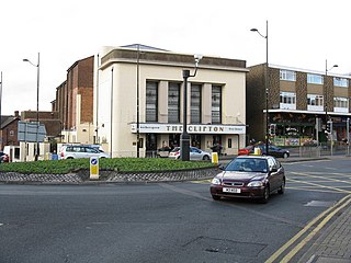
Merry Hill is a suburb of Wolverhampton, West Midlands and a ward of Wolverhampton City Council. It is situated in the south-west of the city, bordering South Staffordshire and the Tettenhall Wightwick, Park, Graiseley and Penn wards. It forms part of the Wolverhampton South West constituency.
Graiseley is both an inner-city area of Wolverhampton, situated immediately to the south-west of the city centre, and the name of a ward of Wolverhampton City Council.
Tettenhall Wightwick is a ward of Wolverhampton City Council, West Midlands. The population of this ward taken at the 2011 census was 10,872.
Aldersley is a suburb of Wolverhampton, West Midlands, England. It is north-west of Wolverhampton city centre, within the Tettenhall Regis ward. Aldersley is a relatively modern part of Wolverhampton, with most of the housing stock – both private and council – dating from after World War II.
Fallings Park is a suburb of Wolverhampton, West Midlands, and a ward of Wolverhampton City Council. It is situated in the northeast of the city, bordering South Staffordshire and the Wednesfield North, Heath Town, Bushbury South and Low Hill and Bushbury North wards. It forms part of the Wolverhampton North East constituency. Fallings Park ward covers over 5,000 properties in the following areas: Longknowle, Newbolds, Scotlands, Underhill, Willows. The population of the Wolverhampton Ward taken at the 2011 census was 12,410.
Pendeford is a suburb of Wolverhampton, West Midlands, England. Historically part of Staffordshire, it is situated north-north-west of the city centre, within the Oxley ward of the City of Wolverhampton Council. At the 2011 Census, the population of Pendeford was 5,826, increasing from 4,356 at the 2001 Census.

Wolverhampton is a city and metropolitan borough in the West Midlands, England. Located 13 miles (21 km) northwest of Birmingham, the population in 2021 was 263,700.
