Sandwell is a metropolitan borough of the West Midlands county in England. The borough is named after the Sandwell Priory, and spans a densely populated part of the West Midlands conurbation. Sandwell Metropolitan Borough Council defines the borough as the six amalgamated towns of Oldbury, Rowley Regis, Smethwick, Tipton, Wednesbury and West Bromwich. Rowley Regis includes the towns of Blackheath and Cradley Heath.

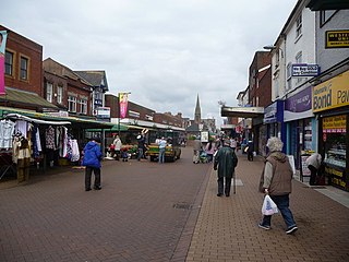
Brierley Hill is a town and electoral ward in the Metropolitan Borough of Dudley, West Midlands, England, 3 miles (4.8 km) south of Dudley and 1 mile (1.6 km) north of Stourbridge. Part of the Black Country and in a heavily industrialised area, it has a population of 13,935 at the 2011 census. It is best known for glass and steel manufacturing, although the industry has declined considerably since the 1970s. One of the largest factories in the area was the Round Oak Steelworks, which closed down and was redeveloped in the 1980s to become the Merry Hill Shopping Centre. Brierley Hill was originally in Staffordshire.
Hall Green is an area in southeast Birmingham, England, synonymous with the B28 postcode. It is also a council constituency of Birmingham City Council, managed by its own district committee. Historically it lay within the county of Worcestershire. The 2001 Population Census found that there were 25,921 people living in Hall Green with a population density of 4,867 people per km2, this compares with 3,649 people per km2 for Birmingham.
Wednesfield is a town and historic village in the City of Wolverhampton, in the county of the West Midlands, England, It is 2 miles (3.2 km) east-northeast of Wolverhampton city centre and about 10 miles (16 km) from Birmingham and is part of the West Midlands conurbation. It was historically within the county of Staffordshire.

Penn is an area which is divided between the City of Wolverhampton and South Staffordshire district. The population of the Wolverhampton Ward taken at the 2011 census was 12,718. Originally, it was a village in the historic county of Staffordshire. There is considerable confusion about exactly which areas fall within Penn. In 19th century censuses, Merry Hill, Bradmore are understood to form part of Penn, although these areas are generally understood to be separate today. However, there has never been any doubt that the two historic settlements of Upper and Lower Penn form the core of the area.

Coseley is a village in the Dudley district, in the county of the West Midlands, England. It is situated three miles north of Dudley itself, on the border with Wolverhampton and Sandwell. It falls within the Tipton and Wednesbury parliamentary constituency.

Wolverhampton North East is a borough constituency represented in the House of Commons of the Parliament of the United Kingdom. It elects one Member of Parliament (MP) by the first past the post system of election. It is represented by Sureena Brackenridge of the Labour Party, who was elected at the 2024 general election.

Wolverhampton South East is a constituency in West Midlands that was created in 1974. The seat has been represented in the House of Commons of the Parliament of the United Kingdom by Pat McFadden of the Labour Party since 2005. McFadden currently serves as Chancellor of the Duchy of Lancaster under the government of Keir Starmer.
Wolverhampton South West was a constituency in the West Midlands created in 1950 and was represented in the House of Commons of the UK Parliament.
Park, or Park Ward, is a ward of Wolverhampton City Council, West Midlands. It is located to the west of the city centre, and covers parts of the suburbs Bradmore, Compton, Finchfield, Merridale, Newbridge and Whitmore Reans. It borders the St Peter's, Graiseley, Merry Hill, Tettenhall Wightwick and Tettenhall Regis wards. It forms part of the Wolverhampton West constituency.
Graiseley is both an inner-city area of Wolverhampton, situated immediately to the south-west of the city centre, and the name of a ward of Wolverhampton City Council.
Tettenhall Wightwick is a ward of Wolverhampton City Council, West Midlands. The population of this ward taken at the 2011 census was 10,872.
Tettenhall Regis is a ward of Wolverhampton City Council, West Midlands. The population of this ward at the 2011 census was 11,911.
Bilston North is a ward of City of Wolverhampton Council, West Midlands. As its name suggests, it covers the northern parts of the town of Bilston, such as Bunkers Hill, Portobello. It borders the Bilston South, Ettingshall North and East Park wards, and the Metropolitan Borough of Walsall. It forms part of the Wolverhampton South East constituency.

Ettingshall is an area of Wolverhampton, West Midlands, England. It lies within two wards of Wolverhampton City Council: Ettingshall North and Ettingshall South and Spring Vale. The population of Ettingshall taken at the 2011 census was 13,482.
Wednesfield North is a ward of Wolverhampton City Council, West Midlands. As the name suggests, it covers the northern parts of the town of Wednesfield. It borders the Wednesfield South, Heath Town and Fallings Park wards, as well as South Staffordshire and the Metropolitan Borough of Walsall. It forms part of the Wolverhampton North East constituency.
Wall Heath is a suburban village in the Dudley Metropolitan Borough in the West Midlands of England. It is located on the A449 road, approximately 1.5 miles northwest of Kingswinford, 5 miles west of Dudley Town Centre and 9 miles north of Kidderminster. It forms part of the West Midlands-South Staffordshire border.

Wolverhampton West is a borough constituency in the city of Wolverhampton in the West Midlands of England which was re-established for the 2024 general election following the 2023 Periodic Review of Westminster constituencies and which is formed largely from the former Wolverhampton South West constituency. It has been represented in the House of Commons since 2024 by Warinder Juss.
The 1999 Wolverhampton Metropolitan Borough Council election took place on 6 May 1999 to elect members of Wolverhampton Metropolitan Borough Council in the West Midlands, England. One third of the council was up for election and the Labour party kept overall control of the council. Overall turnout in the election was 30.63%.

