
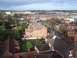
Ettingshall is an area of Wolverhampton, West Midlands, England. It lies within two wards of Wolverhampton City Council: Ettingshall North and Ettingshall South and Spring Vale. The population of Ettingshall taken at the 2011 census was 13,482. [1]
Ettingshall is an area of Wolverhampton, West Midlands, England. It lies within two wards of Wolverhampton City Council: Ettingshall North and Ettingshall South and Spring Vale. The population of Ettingshall taken at the 2011 census was 13,482. [1]

Historically part of Staffordshire, Ettingshall was mentioned as an ancient manor in the Domesday Book of 1086. The surrounding areas of Priestfield, Parkfield, Lanesfield and Millfields are believed to have been property of the manor. [2]
From the 18th century onwards, Ettingshall became heavily industrialised as a result of the Industrial Revolution. Until April 1979, an area of wasteland on the southside of Millfields Road was the location of the Bilston Steelworks and old Bilston quarries. Ettingshall Road was the location for Cables and Instruments, Dixon's Wallcoverings and Tools and Machines. Spring Road was the location of Tarmac Limited (head office closed 2013) and John Thompson Limited (closed 2004). Ettingshall was the location for the manufacture of the 240 ton boiler drum with a length of 122 feet in 1965. This was the heaviest load carried by British Rail. It was transported to Eggborough in Yorkshire. [2]
It is situated 1¼ miles to the south-east of the city centre and centred on the A4039 and A4126 roads. [2] It is situated on the western edge of the former Borough of Bilston and began as an expansion of the Sedgley village of Ettingshall in the Victorian era, becoming part of the new Coseley Urban District Council in 1897.
As the northern parts of the original Ettingshall extended across the border into Bilston, many new houses and factories were built and this area became known as "Ettingshall New Village", the Ettingshall that still exists in the present day.
In 1966, the bulk of the old Ettingshall village was absorbed into the borough of Wolverhampton, along with parts of Brierley village, while most of the rest of Coseley along Brierley Hill and the bulk of neighbouring Sedgley – was incorporated into an expanded Dudley borough. [3]
Ettingshall's population grew in the early 2010s when Persimmon Homes built the Ettingshall Place estate comprising 460 new homes, housing up to 2,200 people. [4] In 2021, a park was created in Ettingshall Place comprising a playground, basketball court, cricket practice pitch and outdoor gym equipment.
A few references to the original village in Sedgley still exist, with the Ettingshall Park Estate below the eastern slopes of Sedgley Beacon, while two roads in Coseley, Upper Ettingshall Road and Ettingshall Road still remain, their names reflecting the upper and lower parts of the extensive village.
Until 2023 Ettingshall had a single ward on Wolverhampton Council. It is now represented within two wards: Ettingshall North, which borders East Park, Bilston North, Blakenhall and St Peter's wards, and neighbouring Ettingshall South and Spring Vale ward. The new ward boundaries took effect at the May 2023 Council elections. [5] Both wards form part of the Wolverhampton South East constituency.
The West Midlands Metro tramway has two stops in the area: The Royal (named after the long-closed Royal Wolverhampton Hospital) and Priestfield.
The nearest railway station is Wolverhampton, although the area was served by Ettingshall Road on the Stour Valley Line until the station closed in 1964.
The area is well served by buses with connections to Sedgley, Wolverhampton, Willenhall and Bilston.
Tipton is an industrial town in the metropolitan borough of Sandwell, in the county of the West Midlands, England. It had a population of 38,777 at the 2011 UK Census. It is located northwest of Birmingham and southeast of Wolverhampton. It is also contiguous with nearby towns of Darlaston, Dudley, Wednesbury and Bilston.
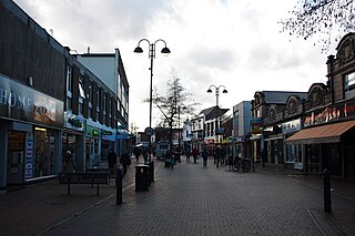
Bilston is a market town in the City of Wolverhampton in the West Midlands, England. It is close to the borders of Sandwell and Walsall. The nearest towns are Darlaston, Wednesbury, and Willenhall. Historically in Staffordshire, four wards of Wolverhampton City Council now cover the town. These are Bilston South and Bilston North, which almost entirely comprise parts of the historic Borough of Bilston and Ettingshall North and Ettingshall South and Spring Vale, which comprise a part of Bilston and other parts of Wolverhampton. The town had a population 34,639 at the 2021 Census.
Sedgley is a town in the north of the Dudley district, in the county of the West Midlands, England.

Penn is an area divided between the City of Wolverhampton and South Staffordshire district. The population of the Wolverhampton Ward taken at the 2011 census was 12,718. Originally, it was a village in the historic county of Staffordshire.
The West Midlands region straddles the historic borders between the counties of Warwickshire, Staffordshire in the north, and Worcestershire in the south.

Coseley is a village in the Dudley district, in the county of the West Midlands, England. It is situated three miles north of Dudley itself, on the border with Wolverhampton and Sandwell. It falls within the Tipton and Wednesbury parliamentary constituency.

Blakenhall is a suburb and ward in Wolverhampton, England. The population was 12,614 at the 2021 census.

Bradley is a suburban village in the City of Wolverhampton, West Midlands County, England. It is located in the Bilston East ward.
Lanesfield is a district now within the boundaries of Wolverhampton, specifically in the city council's Spring Vale ward. Lanesfield lies within the Ancient Manor of Sedgley and was a rural village for many years until the growth of the Black Country's industries. Lanesfield's name originates from the Lane family who lived where the area now stands. Originally, Lanesfield was known as Lane's Field.

Wolverhampton South East is a constituency in West Midlands that was created in 1974. The seat has been represented in the House of Commons of the Parliament of the United Kingdom by Pat McFadden of the Labour Party since 2005. McFadden currently serves as Chancellor of the Duchy of Lancaster under the government of Keir Starmer.
Goldthorn Park is a suburb of Wolverhampton, West Midlands. It is situated 1½ miles south of the city centre within the Blakenhall ward. It mostly consists of private houses built from the 1930s onwards.
Bilston East was a ward of Wolverhampton City Council, West Midlands. It covered Bilston town centre and the southern and eastern parts of the town of Bilston, as well as Bradley. It bordered the Spring Vale, Ettingshall, and Bilston North wards, as well as the Metropolitan Boroughs of Walsall, Sandwell, and Dudley. It formed part of the Wolverhampton South East constituency.
Spring Vale is a district and former ward of Wolverhampton City Council, West Midlands, England. It is situated SSE of the city centre, on the city's border with the Metropolitan Borough of Dudley. The population of the ward at the 2011 census was 12,243.

The County Borough of Dudley was a local government district in the English Midlands from 1865 to 1974. Originally a municipal borough, it became a county borough in 1889, centred on the main town centre of Dudley, along with the suburbs of Netherton and Woodside. Although surrounded by Staffordshire, the borough was associated with Worcestershire for non-administrative purposes, forming an exclave of the county until 1966, when it was transferred to Staffordshire after an expansion of the borough boundaries. Following local government reorganization in 1974, Dudley took in the boroughs of Halesowen and Stourbridge to form the present-day Metropolitan Borough of Dudley, in the newly formed West Midlands county.
Bilston was a parliamentary constituency centred on the town of Bilston in what is now the southeast of the city of Wolverhampton in the West Midlands. It returned one Member of Parliament (MP) to the House of Commons of the Parliament of the United Kingdom.

Tipton Green is the central area of Tipton, a town in the West Midlands of England. It was heavily developed for heavy industry and housing during the 19th century, as Tipton was one of the most significant towns during the Industrial Revolution. Tipton Green is one of three electoral wards covering Tipton for Sandwell Metropolitan Borough Council. The population of this Sandwell ward taken at the 2011 census was 12,834. It is represented by three Labour councillors.
Woodcross is a residential area of Wolverhampton, West Midlands, England. The area traditionally existed within the boundaries of Sedgley and later Coseley until 1966.

Coseley Urban District was a local government district in Staffordshire which was created in 1894.
Sedgley urban district was a local government district within Staffordshire, which was created in 1894 from the western half of the manor of Sedgley.