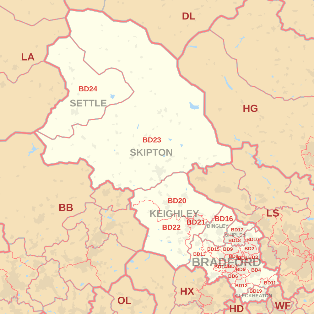
| Postcode district | Post town | Coverage | Local authority area(s) |
|---|
| BD1 | BRADFORD | Bradford City Centre, Little Germany, Goitside, Independent Quarter, West End, City Park | Bradford |
|---|
| BD2 | BRADFORD | Eccleshill, Fagley, Five Lane Ends, Bolton Woods, Ashbourne, Bolton, parts of Undercliffe, Moorside, parts of Wrose | Bradford, Leeds |
|---|
| BD3 | BRADFORD | Barkerend, Bradford Moor, Thornbury, Eastbrook, Pollard Park, parts of, Laisterdyke, parts of Undercliffe, Wapping | Bradford, Leeds |
|---|
| BD4 | BRADFORD | Bierley, East Bowling, East Bierley, Laisterdyke, Tong, Tong Street, Holme Wood, Dudley Hill, Tyersal, Swaine Green, Cutler Heights, Tong Village | Bradford, Leeds, Kirklees |
|---|
| BD5 | BRADFORD | Bankfoot, Little Horton, West Bowling, Canterbury, Marshfields, Ripleyville, | Bradford |
|---|
| BD6 | BRADFORD | Buttershaw, Wibsey, Woodside, Westwood Park, Odsal, Staithgate, parts of Horton Bank Top (Cooperville) | Bradford |
|---|
| BD7 | BRADFORD | Great Horton, Lidget Green, Scholemoor, Horton Bank Top, Horton Grange | Bradford |
|---|
| BD8 | BRADFORD | Manningham, Girlington, White Abbey, Lower Grange, Four Lane Ends, Longlands, West Park, Crossley Hall, Belle Vue | Bradford |
|---|
| BD9 | BRADFORD | Frizinghall, Emm Lane, Heaton, Daisy Hill, Haworth Road Estate, Chellow Heights, Chellow Grange | Bradford |
|---|
| BD10 | BRADFORD | Apperley Bridge, Greengates, Idle, Ravenscliffe, Thackley, Thorpe Edge. | Bradford, Leeds |
|---|
| BD11 | BRADFORD | Adwalton, Birkenshaw, Cockersdale, Drighlington | Kirklees, Leeds |
|---|
| BD12 | BRADFORD | Low Moor, Oakenshaw, Wyke, Lower Wyke, Delph Hill | Bradford, Kirklees |
|---|
| BD13 | BRADFORD | Cullingworth, Clayton Heights Denholme, Queensbury, Thornton, School Green | Bradford |
|---|
| BD14 | BRADFORD | Clayton | Bradford |
|---|
| BD15 | BRADFORD | Allerton, Norr, Wilsden, Sandy Lane | Bradford |
|---|
| BD16 | BINGLEY | Bingley, Cottingley, Eldwick, Harden | Bradford |
|---|
| BD17 | SHIPLEY | Baildon, Shipley | Bradford |
|---|
| BD18 | SHIPLEY | Saltaire, Shipley, Windhill, Wrose | Bradford |
|---|
| BD19 | CLECKHEATON | Cleckheaton, Gomersal, Scholes | Kirklees |
|---|
| BD20 | KEIGHLEY | Cononley, Lothersdale, Cross Hills, East Morton, Glusburn, Kildwick, Silsden, Steeton, Utley, Riddlesden, Sutton-in-Craven, Bradley, Farnhill | Bradford, North Yorkshire |
|---|
| BD21 | KEIGHLEY | Hainworth, Keighley | Bradford |
|---|
| BD22 | KEIGHLEY | Cowling, Haworth, Oakworth, Oxenhope, Cross Roads | Bradford |
|---|
| BD23 | SKIPTON | Bracewell, Carleton-in-Craven, Embsay, Thornton in Craven, Gargrave, Grassington, Hebden, Hellifield, Horton, Kettlewell, Kirkby Malham, Skipton, Threshfield, Tosside | North Yorkshire, Ribble Valley |
|---|
| BD24 | SETTLE | Giggleswick, Horton in Ribblesdale, Settle | North Yorkshire |
|---|
| BD97 | BINGLEY | | non-geographic |
|---|
| BD98 | BRADFORD | | non-geographic |
|---|
| SHIPLEY |
| BD99 | BRADFORD | Euroway Trading Estate M606 | non-geographic |
|---|