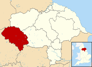
Craven is a local government district of North Yorkshire, England centred on the market town of Skipton. In 1974, Craven District was formed as the merger of Skipton urban district, Settle Rural District and most of Skipton Rural District, all in the West Riding of Yorkshire. The population of the Local Authority area at the 2011 Census was 55,409. It comprises the upper reaches of Airedale, Wharfedale, Ribblesdale, and includes most of the Aire Gap and Craven Basin.

Ribble Valley is a local government district with borough status within the non-metropolitan county of Lancashire, England. The total population of the non-metropolitan district at the 2011 Census was 57,132. Its council is based in Clitheroe. Other places include Whalley, Longridge and Ribchester. The area is so called due to the River Ribble which flows in its final stages towards its estuary near Preston. The area is popular with tourists who enjoy the area's natural unspoilt beauty, much of which lies within the Forest of Bowland.

Pen-y-ghent or Penyghent is a fell in the Yorkshire Dales, England. It is the lowest of Yorkshire's Three Peaks at 2,277 feet (694 m); the other two being Ingleborough and Whernside. It lies 1.9 miles (3 km) east of Horton in Ribblesdale. It has a number of interesting geological features, such as Hunt Pot, and further down, Hull Pot. The waters that flow in have created an extensive cave system which rises at Brants Gill head.
Bolton-by-Bowland is a village and civil parish in the Ribble Valley district of Lancashire, England. Before 1974, the village was part of Bowland Rural District in the West Riding of Yorkshire. According to the census of 2001, the parish had a population of just 498, rising marginally to 499 at the census of 2011.
The Ribble way is a long-distance walk between the Lancashire coast and the Yorkshire Dales National Park largely following the course of the River Ribble.

Stock Beck is a minor river in the West Craven area of Pendle, Lancashire. It is 8.25 miles (13.27 km) long and has a catchment area of 14.41 square miles (3,731.89 ha).

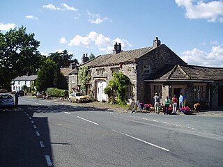
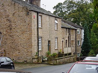
Gisburn is a village and civil parish within the Ribble Valley borough of Lancashire, England. Historically within the West Riding of Yorkshire, it lies 8 miles (13 km) northeast of Clitheroe and 11 miles (18 km) west of Skipton. The civil parish had a population of 506, recorded in the 2001 census, increasing to 521 at the 2011 Census.
Wiswell is a small village and civil parish in the Ribble Valley, Lancashire, England, close to Whalley and Clitheroe at the foot of Wiswell Moor.

Ightenhill is a civil parish in the Borough of Burnley in Lancashire, England, with a population of 1,975.

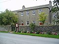
Newsholme is a small village and civil parish in the Ribble Valley, Lancashire, England, but lies within the historic West Riding of Yorkshire. According to the 2001 census, the parish had a population of 50, however the United Kingdom Census 2011 grouped the parish with Horton and Paythorne, giving a total of 253. Today it lies near the boundary with North Yorkshire on the A682, 4 miles (6 km) north of Barnoldswick and 12 miles (19 km) west of Skipton.

The Burnley Way is a 40-mile (64 km) long distance footpath in Lancashire, England. As a circular walk it can be walked from any point, but it is common to start and finish at the Weavers' Triangle Visitor Centre in Burnley. It covers a range of terrain from canal towpaths to open moorland.

Downham is a village and civil parish in Lancashire, England. It is in the Ribble Valley district and at the United Kingdom 2001 census had a population of 156. The 2011 Census includes neighbouring Twiston giving a total for both parishes of 214. The village is on the north side of Pendle Hill off the A59 road about 3 miles (4.8 km) from Clitheroe. Much of the parish, including the village is part of the Forest of Bowland Area of Outstanding Natural Beauty (AONB). It adjoins the Ribble Valley parishes of Rimington, Twiston, Worston, Chatburn and Sawley, and the Pendle parish of Barley-with-Wheatley Booth.

Rimington is a rural village and civil parish in the Ribble Valley, Lancashire, England. The population of the civil parish was 382 at the 2001 Census, however at the 2011 Census Middop was included with Rimington giving a total of 480. It is east of Clitheroe and south of the A59 road. The village consists of the hamlets of Howgill, Martin Top, Newby, and Stopper Lane, and was formerly in the West Riding of Yorkshire.

Sawley is a village and civil parish in the Borough of Ribble Valley in Lancashire, England. The population of the civil parish was 305 at the 2001 Census, rising to 345 at the 2011 census. It is situated north-east of Clitheroe, on the River Ribble. It was historically part of the West Riding of Yorkshire.

Worsthorne-with-Hurstwood is a civil parish in the Borough of Burnley, in Lancashire, England. Situated on the eastern outskirts of Burnley, in 2011 it had a population of 2,963.

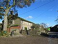
Paythorne is a small village and civil parish in Ribble Valley, Lancashire, England. It is situated alongside the River Ribble, north-east of Clitheroe, and on the boundary with North Yorkshire. Other parishes adjacent to Paythorne are Halton West, Nappa, Newsholme, Horton, Gisburn, Sawley, Bolton-by-Bowland and Gisburn Forest. The nearest town is Barnoldswick, situated 7 kilometres (4.3 mi) south-east of the village. Paythorne is on the edge of the Forest of Bowland Area of Outstanding Natural Beauty, although only a small area in the west of the parish is within the area's boundary. The Ribble Way long-distance walk passes through the village.
Twiston is a village and a civil parish in the Ribble Valley District, in the English county of Lancashire. It is near the town of Clitheroe and the village of Downham. The parish is part of the Forest of Bowland Area of Outstanding Natural Beauty (AONB). It adjoins the Ribble Valley parishes of Downham and Rimington, and the Pendle parish of Barley-with-Wheatley Booth.
Easington is a civil parish within the Ribble Valley district of Lancashire, England, with a population in 2001 of 52. The Census 2011 population details have been grouped with the parish of Slaidburn. Before 1974, it formed part of Bowland Rural District in the West Riding of Yorkshire. It covers just over 9000 acres.

Gisburn Forest is a civil parish in the Ribble Valley, in Lancashire, England. Mainly lying within the Forest of Bowland Area of Outstanding Natural Beauty, the parish includes the larger part of the village of Tosside and the hamlet of Grunsagill to the south. Historically, the parish lay within the West Riding of Yorkshire. It had a population of 151 at the 2011 Census.

Middop is a rural hamlet and civil parish in Lancashire, England. It is in Ribble Valley district. Middop is near the villages of Rimington and Gisburn and approximately 8 miles (13 km) north-east of its post town, Clitheroe. In the 2001 United Kingdom census, Middop had a population of 43. Owing to the limited population from the 2011 Census details are included in the parish of Rimington.