The Forest of Bowland, also known as the Bowland Fells and formerly the Chase of Bowland, is an area of gritstone fells, deep valleys and peat moorland, mostly in north-east Lancashire, England, with a small part in North Yorkshire. It is a western outlier of the Pennines.

Ribble Valley is a local government district with borough status in Lancashire, England. Its council is based in Clitheroe, the largest town. The borough also includes the town of Longridge and numerous villages and surrounding rural areas. It is named after the River Ribble. Much of the district lies within the Forest of Bowland, a designated Area of Outstanding Natural Beauty.
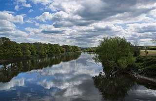
The River Ribble runs through North Yorkshire and Lancashire in Northern England. It starts close to the Ribblehead Viaduct in North Yorkshire, and is one of the few that start in the Yorkshire Dales and flow westwards towards the Irish Sea.

Stonyhurst is the name of a 1,000-acre (4 km2) rural estate owned by the Society of Jesus near Clitheroe in Lancashire, England. It is centred on Stonyhurst College, occupying the great house, its preparatory school Stonyhurst Saint Mary's Hall and the parish church, St Peter's.

Newton or Newton-in-Bowland is a village and civil parish in the Ribble Valley district, in the county of Lancashire, England, formerly known as Newton-on-Hodder. The civil parish had a population of 237 in 2001, according to the United Kingdom Census, increasing to 315 at the 2011 Census. The township covers almost 6,000 acres of the Forest of Bowland. Historically, the village is part of the West Riding of Yorkshire, but was transferred to Lancashire for administrative purposes on 1 April 1974, under the provisions of the Local Government Act 1972.

Aighton, Bailey and Chaigley is a civil parish in the Borough of Ribble Valley in Lancashire, England, just west of Clitheroe. The population of the civil parish at the 2011 census was 1,307, an increase from 1,249 in 2001.

Bashall Eaves is a village and civil parish in the Ribble Valley district of Lancashire, England, about four miles (6 km) west of Clitheroe. The placename element eaves is Old English and refers to Bashall's location on the borders of the Forest of Bowland. Historically, the village is part of the West Riding of Yorkshire, but was transferred to Lancashire for administrative purposes on 1 April 1974, under the provisions of the Local Government Act 1972.

Slaidburn is a village and civil parish within the Ribble Valley district of Lancashire, England. The parish covers just over 5,000 acres of the Forest of Bowland.

Bowland Forest Low is a civil parish in the Ribble Valley district of Lancashire, England, covering some 5,500 acres (22 km2) of the Forest of Bowland. According to the 2001 census, the parish had a population of 168, falling to 160 at the 2011 Census. The parish includes the hamlets of Whitewell and Cow Ark. From northwards clockwise, it borders the civil parishes of Newton, Bashall Eaves, Aighton, Bailey and Chaigley, Bowland-with-Leagram and Bowland Forest High. Before 1974, it formed part of Bowland Rural District in the West Riding of Yorkshire.

Bowland Forest High is a civil parish in the Ribble Valley district of Lancashire, England, covering some 20,000 acres (80 km2) of the Forest of Bowland. It fell within the ancient boundaries of the West Riding of Yorkshire. According to the 2001 census, the parish had a population of 163, falling to 144 at the 2011 Census. The parish includes the settlements of Hareden, Sykes, and Dunsop Bridge. It covers Sykes Fell, Whins Brow, Croasdale Fell and Wolfhole Crag. Before 1974, it formed part of Bowland Rural District in the West Riding of Yorkshire.

Bowland-with-Leagram is a civil parish in the Ribble Valley district of Lancashire, England, covering part of the Forest of Bowland. According to the census, the parish had a population of 181 in 1951, 128 in 2001 and 169 at the Census 2011.

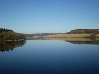
Stocks Reservoir is a reservoir situated at the head of the Hodder valley in the Forest of Bowland, Lancashire, England. It provides water mainly for Blackpool and the Fylde coast. The reservoir has a fly fishing club which is very popular in the summer months and a small cafe which is popular with walkers. The Board House is a building used for meetings by United Utilities and is located on the western shores of the reservoir, near the Hodder Water Treatment Works. Stocks Reservoir was opened on 5 July 1932 by Prince George, K.G.
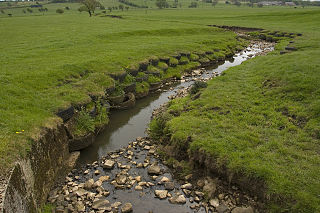
The River Loud is a river of Lancashire, England.
Longridge Fell is the most southerly fell in England, near the town of Longridge, Lancashire. It lies at the southern end of the Forest of Bowland Area of Outstanding Natural Beauty. As its name suggests, it takes the form of a long ridge which rises in a north-easterly direction from within the town of Longridge to its summit 4.5 miles distant. As the ridge curves towards the east, it comes to a sudden end and drops into the Hodder Valley. The fell is an example of a cuesta; the ridge has a sharp drop or escarpment on its northern side, and a gentler, more varying slope on its southern side. These features make it a popular takeoff for hang-gliders and paragliders on the relatively infrequent occurrences of a northerly wind.

West Bradford is a village and civil parish in Lancashire, England, 2.5 miles (4 km) north of Clitheroe. The population at the 2011 census was 788. It covers some 2000 acres of the Forest of Bowland. In Domesday, it is recorded as Bradeford and in the thirteenth century, Braford in Bouland. It was part of the West Riding of Yorkshire until 1974. "West Bradford" was introduced in the nineteenth century at the start of postal services to distinguish the village from the city of the same name.

The Trough of Bowland is a valley and high pass in the Forest of Bowland Area of Outstanding Natural Beauty, Lancashire, England.

Grindleton is a village and civil parish in the Ribble Valley district of the English county of Lancashire, traditionally in the West Riding of Yorkshire. Its 3,700 acres sit within the Forest of Bowland. The population of the civil ward taken at the 2011 census was 772.

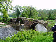
Great Mitton is a village and a civil parish in the Ribble Valley, Lancashire, England. It is separated from the civil parish of Little Mitton by the River Ribble, both lie about three miles from the town of Clitheroe. The combined population of both civil parishes at the 2011 census was 266. In total, Great and Little Mitton cover less than 2000 acres of the Forest of Bowland, making it the smallest township in the Forest. Historically, the village is part of the West Riding of Yorkshire, but was transferred to Lancashire for administrative purposes on 1 April 1974, under the provisions of the Local Government Act 1972.
Easington is a civil parish within the Ribble Valley district of Lancashire, England, with a population in 2001 of 52. The Census 2011 population details have been grouped with the parish of Slaidburn. Before 1974, it formed part of Bowland Rural District in the West Riding of Yorkshire. It covers just over 9000 acres.

Langden Brook is a watercourse in the Trough of Bowland, Lancashire, England. A tributary of the River Hodder, its source is near the summit of Hawthornthwaite Fell, which has an elevation of 479 m (1,572 ft). From there, it flows down the fell's southern face, before turning northeast for around 2.5 miles (4.0 km). At Sykes, in Bowland Forest High, it turns southeast for about 2 miles (3.2 km), joining the Hodder a short distance later, about 0.5 miles (0.80 km) south of Dunsop Bridge.