
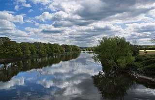
The River Darwen runs through Darwen and Blackburn in Lancashire, England, eventually joining the River Ribble at Walton le Dale south of Preston on its way to the Ribble Estuary.
The River Darwen runs through Darwen and Blackburn in Lancashire, England, eventually joining the River Ribble at Walton le Dale south of Preston on its way to the Ribble Estuary.
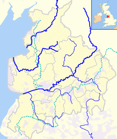
Originating at Jack's Key Clough where Grain Brook and Grainings Brook meet, the two streams from Bull Hill and Cranberry Moss respectively, [1] the river flows through the town of Darwen, continuing into the suburbs of Blackburn past Ewood Park. The river passes below the Leeds and Liverpool Canal at Ewood Aqueduct and is culverted again at Waterfall and near Griffin Park. It is joined by the River Blakewater near Witton Country Park in Blackburn and leaves the mostly urban landscapes of the towns behind, flowing through parklands and valleys. [2] A further tributary, the River Roddlesworth, joins the Darwen at the bottom of Moulden Brow on the boundary between Blackburn with Darwen and Chorley Borough Council (the name Moulden Brow being associated with Moulden Water, an alternative name for this stretch of the river). From there, the Darwen flows past Hoghton Tower through Hoghton Bottoms and Samlesbury Bottoms, finally combining with the River Ribble at Walton-le-Dale. [3]
" While Darwent Streams with Blood of Scots imbru'd..."
The river was polluted with human and industrial effluent during the Industrial Revolution, and this contamination continued until the early 1970s. The river often changed colour dramatically as a result of paper and paint mills routinely using the river water to flush out dye and paint tanks. This process has now ceased, and as a result the river water is now relatively clear which has resulted in the return of trout and small fish. In 2012 a section of the river which had remained in a culvert for 100 years was uncovered at an area of Darwen known as Shorey Bank. [7] Throughout the course of the river many improvements have resulted in improved water quality. [8]

Blackburn is an industrial town and the administrative centre of the Blackburn with Darwen borough in Lancashire, England. The town is north of the West Pennine Moors on the southern edge of the Ribble Valley, 8 mi (13 km) east of Preston and 21 mi (34 km) north-northwest of Manchester. Blackburn is the core centre of the wider unitary authority area along with the town of Darwen. It is the second largest town in Lancashire.

South Ribble is a local government district with borough status in Lancashire, England. Its council is based in Leyland. The borough also includes the towns and villages of Penwortham, Leyland, Farington, Hutton, Longton, Walmer Bridge, Salmesbury, Lostock Hall, Walton le Dale and Bamber Bridge. Many of the built-up areas in the borough form part of the wider Preston built-up area.
The River Ribble runs through North Yorkshire and Lancashire in Northern England. It starts close to the Ribblehead Viaduct in North Yorkshire, and is one of the few that start in the Yorkshire Dales and flow westwards towards the Irish Sea.
Blackburn Hundred is a historic sub-division of the county of Lancashire, in northern England. Its chief town was Blackburn, in the southwest of the hundred. It covered an area similar to modern East Lancashire, including the current districts of Ribble Valley, Pendle, Burnley, Rossendale, Hyndburn, Blackburn with Darwen, and South Ribble.

The River Blakewater is a river running through Lancashire, giving its name to the town of Blackburn.
A civil parish is a subnational entity, forming the lowest unit of local government in England. There are 219 civil parishes in the ceremonial county of Lancashire; Blackpool is completely unparished; Pendle and Ribble Valley are entirely parished. At the 2001 census, there were 587,074 people living in the 219 parishes, accounting for 41.5 per cent of the county's population.

Walton-le-Dale is a large village in the borough of South Ribble, in Lancashire, England. It lies on the south bank of the River Ribble, opposite the city of Preston, adjacent to Bamber Bridge. The population of the South Ribble Ward at the 2011 census was 3,792. To the west of Walton-le-Dale is the residential area of Walton Park.

The diocese of Blackburn is diocese of the Church of England in North West England. Its boundaries correspond to northern Lancashire with the exception of the eastern part of the Forest of Bowland, which is part of the diocese of Leeds. The diocese contains 211 parishes and 280 churches. Blackburn Cathedral is the seat of the bishop of Blackburn, currently Philip North, and the diocesan offices are also located in Blackburn.

The West Pennine Moors is an area of the Pennines covering approximately 90 square miles (230 km2) of moorland and reservoirs in Lancashire and Greater Manchester, England. It is a Site of Special Scientific Interest.

The River Calder is a major tributary of the River Ribble in Lancashire, England, and is around 20 miles (32 km) in length.

The River Roddlesworth is a river in Lancashire, England, a tributary of the River Darwen.

Chorley Interchange is a bus station in Chorley, England.

Higher Walton is a village in South Ribble, Lancashire, England. It is on the old road between Blackburn and Preston where it crosses the River Darwen. The road, at this point, is now part of the A675. Nearby places include Walton-le-Dale, Coupe Green, and Bamber Bridge.
St Leonard's Church is an Anglican church in Walton-le-Dale, Lancashire, England. It is an active parish church in the Diocese of Blackburn and the archdeaconry of Blackburn. In 1950 it was designated as a Grade II* listed building. Parts of the church date from the 16th century and the nave and transepts were rebuilt in the early 20th century.
