
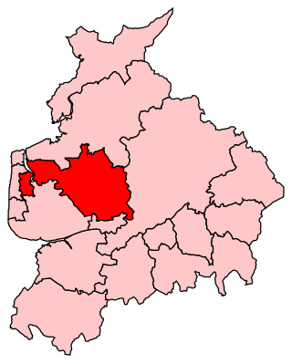
Wyre is a local government district with borough status on the coast of Lancashire, England. The council is based in Poulton-le-Fylde and the borough also contains the towns of Cleveleys, Fleetwood, Garstang, Preesall and Thornton, along with numerous villages and surrounding rural areas. Some of the borough's built-up areas form part of the wider Blackpool urban area. Eastern parts of the borough lie within the Forest of Bowland, a designated Area of Outstanding Natural Beauty.
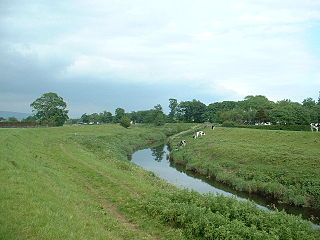
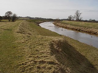
The River Wyre in Lancashire, England, flows into the Irish Sea at Fleetwood. It is 28 miles (45 km) long and has a sheltered estuary which penetrates deep into the Fylde peninsula.

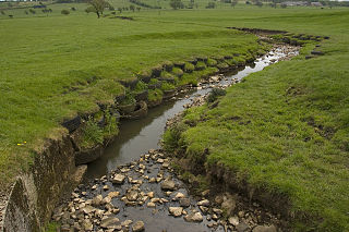
Bleasdale is a village and civil parish in the Wyre district of Lancashire, England, in the Forest of Bowland Area of Outstanding Natural Beauty. The two sources of the River Brock lie within the parish. According to the 2001 census, it had a population of 147, increasing to 167 at the 2011 Census.
Over Wyre is the collective name given to a group of villages in Lancashire, England, situated on the Fylde, to the north and east of the River Wyre. The group is usually considered to include Hambleton, Stalmine, Knott End-on-Sea, Preesall, Pilling and Out Rawcliffe. The name distinguishes these villages from the larger southern part of the Fylde, between the Wyre and the Ribble, which includes the urban areas of Blackpool, Poulton-le-Fylde, Thornton, Cleveleys, Fleetwood and Lytham St Annes.

Lancaster and Wyre was a parliamentary constituency represented in the House of Commons of the Parliament of the United Kingdom. From 1997 to 2010, it elected one Member of Parliament (MP) by the first past the post system of election, but has now been replaced by Lancaster and Fleetwood.
Wyre and Preston North is a county constituency represented in the House of Commons of the Parliament of the United Kingdom. Created in the most recent fifth periodic review of constituencies by the Boundary Commission for England, it elects one Member of Parliament (MP) by the first past the post voting system.

Blackpool North and Cleveleys is a constituency represented in the House of Commons of the UK Parliament since 2010 by Paul Maynard, a Conservative.
Wyre was a parliamentary constituency in the Wyre district of Lancashire. It returned one Member of Parliament (MP) to the House of Commons of the Parliament of the United Kingdom from 1983 until it was abolished for the 1997 general election. It was then partially replaced by the new constituency of Lancaster and Wyre.
Main Dyke is a water channel running through the Fylde area of Lancashire in England.
The River Loud is a river of Lancashire, England.
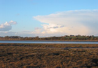
The Fylde is a coastal plain in western Lancashire, England. It is roughly a 13-mile-long (21-kilometre) square-shaped peninsula, bounded by Morecambe Bay to the north, the Ribble estuary to the south, the Irish Sea to the west, and the foot of the Bowland hills to the east which approximates to a section of the M6 motorway and West Coast Main Line.

The A585 is a primary road in England which runs from Kirkham to Fleetwood in Lancashire.

The River Grizedale, also known as Grizedale Beck, is a river in Lancashire, England.
Great Eccleston is a village and civil parish in Lancashire, England situated on a coastal plain called the Fylde. The village lies to the south of the River Wyre and the A586 road, approximately 10 miles (16 km) upstream from Fleetwood. At the 2001 census, the parish had a population of 1,473, rising slightly to 1,486 at the 2011 census.
The A588 is a road in England which runs from Poulton-le-Fylde to Lancaster in Lancashire. It is the main route serving the Over Wyre areas of the Fylde.

The A586 is a road in England, which runs from Garstang to Blackpool, in Lancashire.
Wyresdale Abbey was a short-lived medieval monastic house in Over Wyresdale, Lancashire, England. It was founded around 1170 or a little later and ceased to exist by 1204.

Upper Rawcliffe-with-Tarnacre is a civil parish on the Fylde, in the Borough of Wyre, in Lancashire, England. It had a population of 604 in 2001, increasing to 629 at the 2011 Census. The only settlements in the parish are the village of St Michael's on Wyre and the tiny hamlet of Ratten Row. The River Wyre passes through the parish, and the River Brock joins the Wyre on the parish boundary.

Myerscough is a hamlet and former civil parish on the River Brock, 14 miles (23 km) from Lancaster, now in the parish of Myerscough and Bilsborrow, in the Wyre district, in the county of Lancashire, England. In 2001 it has a population of 1111. Since 1267 the Duchy of Lancaster has had land holdings in Myerscough.

Hillylaid Pool is a water channel running through the Fylde and Wyre areas of Lancashire in England. It is 4.55 miles (7.32 km) long, and it is part of the Fleetwood Peninsula Tributary catchment area.

