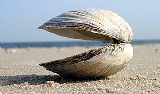
Clam is a common name for several kinds of bivalve mollusc. The word is often applied only to those that are edible and live as infauna, spending most of their lives halfway buried in the sand of the sea floor or riverbeds. Clams have two shells of equal size connected by two adductor muscles and have a powerful burrowing foot. They live in both freshwater and marine environments; in salt water they prefer to burrow down into the mud and the turbidity of the water required varies with species and location; the greatest diversity of these is in North America.

Morecambe Bay is an estuary in north-west England, just to the south of the Lake District National Park. It is the largest expanse of intertidal mudflats and sand in the United Kingdom, covering a total area of 120 sq mi (310 km2). In 1974, the second largest gas field in the UK was discovered 25 mi (40 km) west of Blackpool, with original reserves of over 7 trillion cubic feet (tcf). At its peak, 15% of Britain's gas supply came from the bay but production is now in decline. Morecambe Bay is also an important wildlife site, with abundant birdlife and varied marine habitats.

Lytham St Annes is a seaside town in the Borough of Fylde in Lancashire, England. It is on the Fylde coast, directly south of Blackpool on the Ribble Estuary. The population of the built-up area at the 2021 census was 42,695. The town is made up of the four areas of Lytham, Ansdell, Fairhaven and St Annes-on-the-Sea.

Poulton-le-Fylde, commonly shortened to Poulton, is a market town in Lancashire, England, situated on the coastal plain called the Fylde. In the 2021 United Kingdom census, it had a population of 18,115.

Carmarthen Bay is an inlet of the South Wales coast, including notable beaches such as Pendine Sands and Cefn Sidan sands. Carmarthen Bay is partially within the Pembrokeshire Coast National Park. The Joint Nature Conservation Committee list Carmarthen Bay and Estuaries as a Special Area of Conservation.

Fleetwood is a coastal town in the Borough of Wyre in Lancashire, England, at the northwest corner of the Fylde. It had a population of 25,939 at the 2011 census.
Thornton is a village in the Borough of Wyre, about 4 miles (6 km) north of Blackpool and 2 miles (3 km) south of Fleetwood. The civil parish of Thornton became an urban district in 1900, and was renamed Thornton-Cleveleys in 1927. In 2011, the Thornton built-up area sub division had a population of 18,941.

Lancaster and Wyre is a parliamentary constituency represented in the House of Commons of the Parliament of the United Kingdom by Cat Smith of Labour Party. The seat was originally established in 1997 but was replaced by Lancaster and Fleetwood in 2010.
The Preston and Wyre Railway was promoted to open up agricultural land in the Fylde in Lancashire, access a new port at what became Fleetwood and the Lancaster Canal at Preston: it opened in 1840. An associated company built the dock leading to the company changing its name to the Preston and Wyre Railway, Harbour and Dock Company. Passenger business was more buoyant than expected, and the company built branch lines to the nascent resort of Blackpool and Lytham that opened in 1846. At that time the line was leased by the Lancashire and Yorkshire Railway and later the London and North Western Railway took a share in the lease which was later converted to outright ownership. The Preston and Wyre Railway continued to be jointly owned as the Preston and Wyre Joint Railway.

Preesall is a town, civil parish and electoral ward in Lancashire, England. The parish covers the eastern bank of the estuary of the River Wyre, including Knott End-on-Sea, Pilling Lane and the village of Preesall itself. The parish of Preesall had a population of 5,314 recorded in the 2001 census, rising to 5,694 at the 2011 census.
Lancaster and Fleetwood was a constituency created in 2010 represented in the House of Commons of the UK Parliament.

Banks is a large coastal village in the civil parish of North Meols, in the West Lancashire district, in Lancashire, England, south of the Ribble estuary four miles (6 km) north-east of Southport town centre. In 2021 it had a population of 4430. It is in the Southport parliamentary constituency.
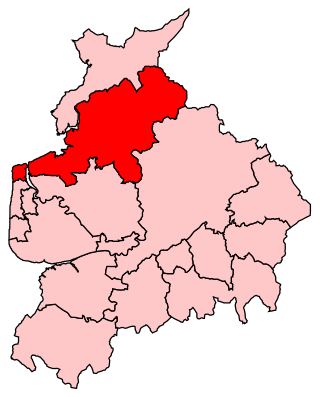
The Fylde is a coastal plain in western Lancashire, England. It is roughly a 13-mile-long (21-kilometre) square-shaped peninsula, bounded by Morecambe Bay to the north, the Ribble estuary to the south, the Irish Sea to the west, and the foot of the Bowland hills to the east which approximates to a section of the M6 motorway and West Coast Main Line.

Pilling is a village and civil parish within the Wyre borough of Lancashire, England. It is 6.5 miles (10.5 km) north-northeast of Poulton-le-Fylde, 9.4 miles (15.1 km) south-southwest of Lancaster and 14.5 miles (23.3 km) northwest of Preston, in a part of the Fylde known as Over Wyre.
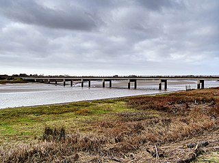
Shard Bridge is a bridge in the English county of Lancashire. It spans the River Wyre, connecting Singleton, on the southern side of the river, to Hambleton, on its northern side, carrying both automotive and pedestrian traffic of the A588 Shard Road. The word shard is a Roman term for "low crossing point on a river".

The A588 is a road in western Lancashire, England, which runs for around 20 miles (32 km), from Poulton-le-Fylde northeastwards to Lancaster. It is the main route serving the Over Wyre areas of the Fylde.

Garstang is an ancient market town and civil parish within the Wyre borough of Lancashire, England. It is 10 miles (16 km) north of the city of Preston and the same distance south of Lancaster.
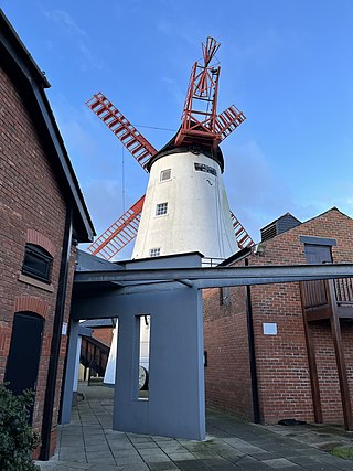
Marsh Mill is an 18th-century tower windmill in Thornton, Lancashire, England. It was built in 1794 by Ralph Slater for local landowner Bold Hesketh. It functioned as a corn mill until the 1920s and has been fully restored. It is a good example of a complete English windmill and has been designated a Grade II* listed building.

Wyre Estuary Country Park is located in Thornton-Cleveleys, Lancashire, England. Established in 1991 and covering 0.79 acres (0.32 ha), it is situated on the western banks of the 28-mile (45 km) long River Wyre, near its mouth at the Irish Sea at Fleetwood. The Wyre estuary forms part of the southern boundary of Morecambe Bay.

Victoria Road is a major thoroughfare in Thornton-Cleveleys, Lancashire, England. Originally known as Ramper Road, it runs for about 2 miles (3.2 km) from Station Road in Thornton, in the east, to South Promenade in Cleveleys, in the west. Its addresses are denoted as "Victoria Road East" or "Victoria Road East", the split occurring at the Amounderness Way roundabout carrying traffic of the A585 between Poulton-le-Fylde and Fleetwood. The road picks up the B5412 designation from Station Road until The Crescent and Brighton Avenue in Cleveleys.


