Wyre is a local government district with borough status on the coast of Lancashire, England. The council is based in Poulton-le-Fylde and the borough also contains the towns of Cleveleys, Fleetwood, Garstang, Preesall and Thornton, along with numerous villages and surrounding rural areas. Some of the borough's built-up areas form part of the wider Blackpool urban area. Eastern parts of the borough lie within the Forest of Bowland, a designated Area of Outstanding Natural Beauty.

Poulton-le-Fylde, commonly shortened to Poulton, is a market town in Lancashire, England, situated on the coastal plain called the Fylde. In the 2021 United Kingdom census, it had a population of 18,115.

Fleetwood is a coastal town in the Borough of Wyre in Lancashire, England, at the northwest corner of the Fylde. It had a population of 25,939 at the 2011 census.
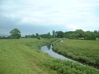
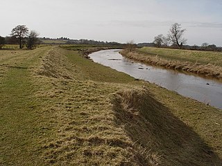
The River Wyre, in Lancashire, England, flows into the Irish Sea at Fleetwood. It is 28 miles (45 km) long and has a sheltered estuary which penetrates deep into the Fylde peninsula.
Over Wyre is the collective name given to a group of villages in Lancashire, England, situated on the Fylde, to the north and east of the River Wyre. The group is usually considered to include Hambleton, Stalmine, Knott End-on-Sea, Preesall, Pilling and Out Rawcliffe. The name distinguishes these villages from the larger southern part of the Fylde, between the Wyre and the Ribble, which includes the urban areas of Blackpool, Poulton-le-Fylde, Thornton, Cleveleys, Fleetwood and Lytham St Annes.

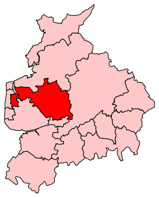
Lancaster and Wyre is a parliamentary constituency represented in the House of Commons of the Parliament of the United Kingdom by Cat Smith of Labour Party. The seat was originally established in 1997 but was replaced by Lancaster and Fleetwood in 2010.
Wyre and Preston North was a county constituency represented in the House of Commons of the Parliament of the United Kingdom. Created in 2010, it elected one Member of Parliament (MP) by the first past the post voting system.

Hambleton is a village and civil parish in the English county of Lancashire. It is situated on a coastal plain called the Fylde and in an area east of the River Wyre known locally as Over Wyre. Hambleton lies approximately 3 miles (4.8 km) north-east of its post town, Poulton-le-Fylde, and about 7 miles (11 km) north-east of the seaside resort of Blackpool. In the 2001 United Kingdom census, the parish had a population of 2,678, increasing to 2,744 at the 2011 census.
The Fylde is a coastal plain in western Lancashire, England. It is roughly a 13-mile-long (21-kilometre) square-shaped peninsula, bounded by Morecambe Bay to the north, the Ribble estuary to the south, the Irish Sea to the west, and the foot of the Bowland hills to the east which approximates to a section of the M6 motorway and West Coast Main Line.

Stalmine is a village in the civil parish of Stalmine-with-Staynall, in the Wyre borough of Lancashire, England, in a part of the Fylde known as Over Wyre. The village is located on a small hill on the A588, the main road between Hambleton and Lancaster, with the highest level 75 ft above sea level. The village name has been spelled Stalmin and Stalemynne. The village had a population of 1,087 at the 2011 Census.

Pilling is a village and civil parish within the Wyre borough of Lancashire, England. It is 6.5 miles (10.5 km) north-northeast of Poulton-le-Fylde, 9.4 miles (15.1 km) south-southwest of Lancaster and 14.5 miles (23.3 km) northwest of Preston, in a part of the Fylde known as Over Wyre.
Great Eccleston is a village and civil parish in Lancashire, England, situated on a coastal plain called the Fylde. The village lies to the south of the River Wyre and the A586 road, approximately 10 miles (16 km) upstream from Fleetwood. At the 2001 census, the parish had a population of 1,473, rising slightly to 1,486 at the 2011 census.

Inskip-with-Sowerby is a civil parish in the Borough of Wyre, in Lancashire, England. A part of the Fylde, the parish includes the village of Inskip and the hamlets Crossmoor to the west and Sowerby to the east. Also Inskip Moss Side lies about a mile north-west of the village at grid reference SD452391. In 2011 it had a population of 840.
Carleton is a village on the coastal plain of the Fylde in the Borough of Wyre in Lancashire, England. It consists of Great Carleton, Little Carleton, Norcross and Whiteholme and is situated close to Poulton-le-Fylde. Other nearby settlements include Thornton, Bispham and Blackpool. Historically, Carleton was in the parish of Poulton-le-Fylde. It borders the Borough of Blackpool immediately to the west.

Skippool is an area of Thornton-Cleveleys, Lancashire, England. It is situated between Little Thornton and Poulton-le-Fylde along the western banks of the River Wyre, about 3 miles (4.8 km) south of its mouth between Fleetwood and Knott End. These banks are known as Skippool Creek, an historic docks area now home to mostly run-down vessels. The MV Good Hope, for example, may date from the 1830s. Skippool Creek is a short branch off Main Dyke, which empties into the River Wyre in front of Blackpool and Fleetwood Yacht Club.

Wardleys was a pub on Wardley's Lane in the civil parish of Stalmine-with-Staynall, near the village of Hambleton, Lancashire. The building dated to the 18th century and occupied a location, on the eastern banks of the River Wyre and beside Wardleys Creek, believed to have been used since Roman times.

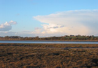
Wyre Estuary Country Park is located in Thornton-Cleveleys, Lancashire, England. Established in 1991 and covering 0.79 acres (0.32 ha), it is situated on the western banks of the 28-mile (45 km) long River Wyre, near its mouth at the Irish Sea at Fleetwood. The Wyre estuary forms part of the southern boundary of Morecambe Bay.

Cockle Hall is an historic location in Thornton-Cleveleys, Lancashire, England. Located in today's Wyre Estuary Country Park, it was the location of one of the earliest crossings of the River Wyre, and was used as such until the 1930s. It is also the former site of a two-storey cottage occupied by the Lawrenson family of thirteen. It was located a short distance along today's footpath running from the car park at Wyre Estuary, along the western banks of the river. The ferryman who took people to and brought people from Wardleys Creek, on the eastern side of the river, also lived there.

Wardleys Creek is an area of Stalmine-with-Staynall, near the village of Hambleton, Lancashire, England. It is located on the eastern banks of the River Wyre, around 4 miles (6.4 km) from the river's mouth at the Irish Sea.