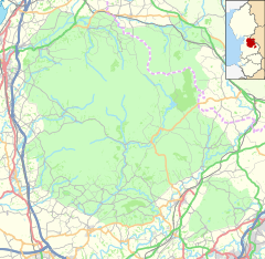
The Forest of Bowland, also known as the Bowland Fells, is an area of barren gritstone fells, deep valleys and peat moorland, mostly in north-east Lancashire, England with a small part in North Yorkshire. It is a western spur of the Pennines and was once described as the "Switzerland of England".
Lancashire is a ceremonial county in North West England. The administrative centre is Preston. The county has a population of 1,449,300 and an area of 1,189 square miles (3,080 km2). People from Lancashire are known as Lancastrians.
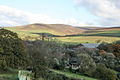
Oakenclough is a small and scattered community, which appears to have developed largely as a result of a paper mill being sited here to make use of the water power available from the swiftly flowing River Calder. In 1827, Quaker John Jackson bought the mill from Richard Curtis, a paper manufacturer and farmer who had gone bankrupt. Jackson built and lived in the adjacent house, known as Calder Bank, where his descendants continued to live for well over a hundred years. Jackson's brothers, Jonathan and Richard, founded nearby Calder Vale in 1835, when they built a mill on the river. It was used to weave cotton and is still in use today, even though the river no longer provides the power.
A paper mill is a factory devoted to making paper from vegetable fibres such as wood pulp, old rags and other ingredients. Prior to the invention and adoption of the Fourdrinier machine and other types of paper machine that use an endless belt, all paper in a paper mill was made by hand, one sheet at a time, by specialized laborers.
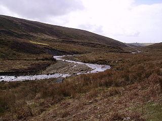
The River Calder is a 13-mile (21 km) long river that is one of the main tributaries of the River Wyre in Lancashire, England. Like the other rivers in England with the name Calder, its name is thought to derive from a mixture of Old Welsh and Old British words meaning "hard and violent water or stream".
Calder Vale is an English village, located on the edge of the Forest of Bowland in Lancashire. It lies on the River Calder in a deep valley with only a single road providing vehicular access. The name Calder is thought to be derived from the Old Norse "kaldr" (cold).
Built by public subscription, St. John's Church, and the small church school next to it, stands at the top of Church Wood between Calder Vale and Oakenclough.
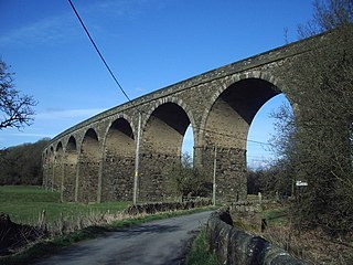
Gallery
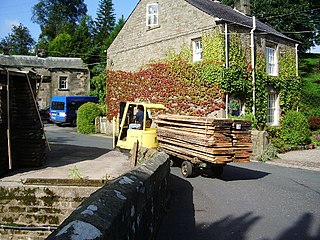
Oakenclough Works. In view is the paper mill, a shed manufacturer, and a scrapyard
A shed is typically a simple, single-story roofed structure in a back garden or on an allotment that is used for storage, hobbies, or as a workshop. Sheds vary considerably in the complexity of their construction and their size, from small open-sided tin-roofed structures to large wood-framed sheds with shingled roofs, windows, and electrical outlets. Sheds used on farms or in industry can be large structures. The main types of shed construction are metal sheathing over a metal frame, plastic sheathing and frame, all-wood construction, and vinyl-sided sheds built over a wooden frame.
Further reading
Wilcock, Jack (2012). The Story of Calder Vale and Oakenclough: A Lancashire Village Victorian Diary. ISBN978-0-9531719-3-4.
The International Standard Book Number (ISBN) is a numeric commercial book identifier which is intended to be unique. Publishers purchase ISBNs from an affiliate of the International ISBN Agency.
This page is based on this Wikipedia article Text is available under the CC BY-SA 4.0 license; additional terms may apply. Images, videos and audio are available under their respective licenses.
Related Research Articles
James Hargreaves was a weaver, carpenter and inventor who lived and worked in Lancashire, England. He was one of three men responsible for the mechanisation of spinning: Hargreaves is credited with inventing the spinning jenny in 1764; Richard Arkwright patented the water frame in 1769; andSamuel Crompton combined the two, creating the spinning mule in 1779.
Read is a village in Lancashire 5 miles west northwest of Burnley and 2 miles east of Whalley. It is on the A671 which is the main road between Burnley and Clitheroe. The population of the civil parish as taken at the 2011 census was 1,419.
Sir Richard Arkwright was an English inventor and a leading entrepreneur during the early Industrial Revolution. He is credited as the driving force behind the development of the spinning frame, known as the water frame after it was adapted to use water power; and he patented a rotary carding engine to convert raw cotton to "cotton lap" prior to spinning. He was the first to develop factories housing both mechanised carding and spinning operations.
Padiham is a small town and civil parish on the River Calder, about three miles (5 km) west of Burnley and south of Pendle Hill, in Lancashire, England. It is part of the Borough of Burnley, but has its own town council with varied powers. Padiham was originally a rural village lying by the River Calder. It is still surrounded by attractive countryside on an arc running from the north-west to the north-east in the foothills of Pendle Hill.
Whalley is a large village and civil parish in the Ribble Valley on the banks of the River Calder in Lancashire, England. It is overlooked by Whalley Nab, a large wooded hill over the river from the village. The population of the civil parish was 2,645 at the census of 2001, and increased to 3,629 at the census of 2011. Watercolour artist Thomas Frederick Worrall painted two scenes entitled Whalley from the Nab and Whalley Nab from Stoneyhurst, c. 1900, which are available on the Watercolour World web site.
A cotton mill is a building housing spinning or weaving machinery for the production of yarn or cloth from cotton, an important product during the Industrial Revolution in the development of the factory system.
The River Cray is the largest tributary of the Darent. It is the prime river of outer, south-east Greater London, rising in Priory Gardens, Orpington, where rainwater percolates through chalk bedrock of the Downs to forms a pond where the eroded ground elevation gives way to impermeable clay. Initially it flows true to form northwards, past industrial and residential St Mary Cray, through St Paul's Cray and through Foots Cray, where it enters the parkland Foots Cray Meadows, flowing under by Five Arches bridge. It then flows by restored Loring Hall (c.1760), home of the Lord Castlereagh who took his own life there in 1822. It continues through North Cray and Bexley. It neighbours a restored Gothic (architecture) cold plunge bath house, built around 1766 as part of Vale Mascal Estate. It is then joined by the River Shuttle and then continues through the parkland of Hall Place, which was built for John Champneys in 1540. The Cray turns eastward through Crayford and Barnes Cray to join the Darent in Dartford Creek. The Creek is a well-watered partly tidal inlet between Crayford Marshes and Dartford Marshes by a slight projection of land, Crayford Ness. The villages through which the Cray flows are collectively known as "The Crays".
Samuel Oldknow (1756–1828) was an English cotton manufacturer.
Ballardvale is a village located within the boundaries of the town of Andover, Essex County, Massachusetts, United States. Growing originally in the 19th century around mills located on the Shawsheen River, the village is a local historic district, boasting many varieties of historic architecture and a rich industrial heritage.
Barnacre-with-Bonds is a civil parish in the Wyre district of Lancashire, England. According to the 2001 census it had a population of 1,751 increasing to 2,148 at the 2011 Census The parish covers an area to the south and east of Garstang, including the settlements of Bonds, Calder Vale and Bowgreave.
The River Calder is a major tributary of the River Ribble in Lancashire, England and is around 20 miles (32 km) in length.
Todmorden Mills was a small settlement located in the Don River valley in Toronto, Ontario. It started out as a lumber mill in the 1790s. Originally known as "Don Mills", it grew into a small industrial complex and village before becoming part of East York in the 20th century. Currently the valley site is occupied by the Todmorden Mills Heritage Museum and Arts Centre, which includes the museum, art gallery, a theatre and a forest preserve.
Healey is a small village and industrial district on the east bank of the River Calder in the southwestern outskirts of Ossett, near Wakefield in West Yorkshire, England. It developed during the industrial revolution when three cloth and fulling mills were built.
The River Brun is a river in eastern Lancashire. It is approximately 4.5 miles (7.2 km) long and has a catchment area of 9.32 square miles (24.134 km2).
Cliviger is a civil parish in the Borough of Burnley, in Lancashire, England. It is situated to the southeast of Burnley, and northwest of Todmorden, having a population of 2,238. Although the whole parish lies within the Borough of Burnley it is actually split between three postal towns, with a few farms lying in either the Todmorden or Bacup postal areas.
Sir Philip Sidney Stott, 1st Baronet, usually known by his full name or as Sidney Stott, was an English architect, civil engineer and surveyor.
Thomas Baylies (1687–1756) was a Quaker ironmaster first in England, then in Massachusetts.
Kirk Mill is an early example of an Arkwright-type cotton mill and a grade II listed building in Chipping, Lancashire, in Ribble Valley, to the north of Preston, Lancashire, England. It was built in the 1780s on the site of a corn mill dating from at least 1544. The mill continued spinning cotton using water frames and then throstles until 1886, when it was sold and became HJ Berry's chairmaking factory.
It was powered by a 32 ft waterwheel which continued in use, generating electricity until the 1940s.