Calder Vale

Last updated

Calder Vale
Village
St. John's church, Calder Vale.jpg
St John's Church
Location map United Kingdom Borough of Wyre.svg
Red pog.svg
Calder Vale
Location in Wyre Borough
Location map United Kingdom Forest of Bowland.svg
Red pog.svg
Calder Vale
Location in the Forest of Bowland
Lancashire UK location map.svg
Red pog.svg
Calder Vale
Location within Lancashire
Population2,148 (2011.Ward)
OS grid reference SD535455
Civil parish
District
Shire county
Region
Country England
Sovereign state United Kingdom
Post town PRESTON
Postcode district PR3
Dialling code 01995
Police Lancashire
Fire Lancashire
Ambulance North West
UK Parliament
List of places
UK
England
Lancashire
53°54′25″N2°42′43″W / 53.907°N 2.712°W / 53.907; -2.712

Calder Vale is an English village, located on the edge of the Forest of Bowland in Lancashire. [1] It lies on the River Calder in a deep valley with only a single cul-de-sac providing vehicular access. The name Calder is thought to be derived from the Old Norse kaldr, which means "cold".

Contents

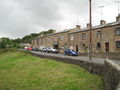
The village was founded by Quakers Jonathan and Richard Jackson, [2] and in 1835 a cotton-weaving mill — the Lappet Mill — was built, powered by the River Calder. The mill and mill pond still exist and Lappet Mill is still working as a cotton mill. One of its main products is the red, black and white checked cloth used for Arab headscarves and it was said that Yasser Arafat's headdresses were made at the Mill. [3] The Jackson brothers also built many of the terraced houses still in occupation close to the mills. [4]

The church of St John the Evangelist lies high above the village, linked to it by a woodland footpath. It was consecrated on 12 August 1863. [5] It serves the adjacent village of Oakenclough, in addition to Calder Vale.

The village also contains a primary school, Calder Vale Church of England School, which was built concurrently with the church. [6] It is a small school consisting of two teachers and about thirty pupils, and it is situated next door to St John's Church, the two being very closely linked.

There is also a village hall and a Methodist chapel in the village centre. The village also has Scouts and Brownies, a Women's Institute, which meets monthly in the village hall, and a Village Club.

There is a post office within the village hall.

Every Sunday in May, the villagers get together and organise the "BlueBell Teas", [7] at which cakes, sandwiches and local produce are sold for charity, and for the upkeep of the village hall and mission room. On the second Saturday of June every year, there is a village festival.

The elected Member for Wyre Borough Council's Calder Ward is Councillor David Meirion Williams. [8]

Governance

The village falls in the electoral ward of Calder. This ward stretches south-east to Barnacre. The total ward population at the 2011 census was 2,148. [9]

See also

Related Research Articles

<span class="mw-page-title-main">Borough of Wyre</span> Borough and non-metropolitan district in England

Wyre is a local government district with borough status on the coast of Lancashire, England. The council is based in Poulton-le-Fylde and the borough also contains the towns of Cleveleys, Fleetwood, Garstang, Preesall and Thornton, along with numerous villages and surrounding rural areas. Some of the borough's built-up areas form part of the wider Blackpool urban area. Eastern parts of the borough lie within the Forest of Bowland, a designated Area of Outstanding Natural Beauty.

<span class="mw-page-title-main">Ribble Valley</span> Borough and non-metropolitan district in England

Ribble Valley is a local government district with borough status in Lancashire, England. Its council is based in Clitheroe, the largest town. The borough also includes the town of Longridge and numerous villages and surrounding rural areas. It is named after the River Ribble. Much of the district lies within the Forest of Bowland, a designated Area of Outstanding Natural Beauty.

<span class="mw-page-title-main">Poulton-le-Fylde</span> Human settlement in England

Poulton-le-Fylde, commonly shortened to Poulton, is a market town in Lancashire, England, situated on the coastal plain called the Fylde. In the 2021 United Kingdom census, it had a population of 18,115.

Burnley Wood is a district and former electoral ward of Burnley, Lancashire. In broad terms the area lies between Parliament Street in the north and Hufling Lane in the south, and from the railway in the west to Todmorden Road in the east. Based on historic definitions of the ward boundary, Burnley Wood could also be defined as including the more affluent areas around the Woodgrove Road area to the east of Todmorden Road, Brooklands Road to the south and the area north of Parliament Street as far as the River Calder. Historically the district was located in the parish and township of Habergham Eaves, separated from the adjacent Burnley township, later Borough by the Calder before being incorporated into the County Borough of Burnley in 1894.

Barnacre-with-Bonds is a civil parish in the Wyre district of Lancashire, England. According to the 2001 census it had a population of 1,751 increasing to 2,148 at the 2011 census. The parish covers an area to the south and east of Garstang, including the settlements of Bonds, Calder Vale and Bowgreave. It is mostly rural and hilly with a small population.

<span class="mw-page-title-main">Dolphinholme</span> Human settlement in England

Dolphinholme is a historic village in Lancashire, North West England.

<span class="mw-page-title-main">St Brides Major</span> Human settlement in Wales

St. Brides Major is a village within the community also called St Brides Major in the Vale of Glamorgan in Wales.

<span class="mw-page-title-main">Chipping, Lancashire</span> Human settlement in England

Chipping is a village and civil parish in the borough of Ribble Valley, Lancashire, England, within the Forest of Bowland Area of Outstanding Natural Beauty. Its grid reference is SD6243, and the nearest substantial settlement is Longridge, nearly 4 mi (6.4 km) to the south. In the 2001 census, the parish had a population of 1,046, falling slightly to 1,043 at the 2011 census. The village has won several best-kept village competitions over the years. The village also won the village section of the Royal Horticultural Society Britain in Bloom competition in 2009, picking up RHS Tourism and Gold achievement awards in the process.

<span class="mw-page-title-main">Hambleton, Lancashire</span> Human settlement in England

Hambleton is a village and civil parish in the English county of Lancashire. It is situated on a coastal plain called the Fylde and in an area east of the River Wyre known locally as Over Wyre. Hambleton lies approximately 3 miles (4.8 km) north-east of its post town, Poulton-le-Fylde, and about 7 miles (11 km) north-east of the seaside resort of Blackpool. In the 2001 United Kingdom census, the parish had a population of 2,678, increasing to 2,744 at the 2011 census.

<span class="mw-page-title-main">River Calder, Wyre</span> River in Lancashire, England

The River Calder is a 13-mile (21 km) long river that is one of the main tributaries of the River Wyre in Lancashire, England. Like the other rivers in England with the name Calder, its name is thought to derive from a mixture of Old Welsh and Old British words meaning "hard and violent water or stream".

<span class="mw-page-title-main">Worsthorne</span> Village in Lancashire, England

Worsthorne is a rural village on the eastern outskirts of Burnley in Lancashire, England. It is in the civil parish of Worsthorne-with-Hurstwood and the borough of Burnley. At the 2011 census the village had a population of 1,028.

<span class="mw-page-title-main">Caton-with-Littledale</span> Civil parish in Lancashire, England

The civil parish of Caton-with-Littledale is situated in Lancashire, England, near the River Lune. The parish lies within the Forest of Bowland Area of Outstanding Natural Beauty and contains the villages of Caton, Brookhouse, Caton Green, Littledale and Townend.

<span class="mw-page-title-main">Waddington, Lancashire</span> Human settlement in England

Waddington is a small village, 2 miles (3 km) north-west of Clitheroe in the Ribble Valley, Lancashire, England. The population of the civil parish at the 2011 census was 1,028. Before the 1974 county boundary changes, Waddington fell just within the Bowland Rural District of the West Riding of Yorkshire. It covers approximately 2000 acres of the Forest of Bowland.

<span class="mw-page-title-main">Claughton, Wyre</span> English village and parish also known as Claughton-on-Brock

Claughton is a sparse village and civil parish in the county of Lancashire in the north of England, in the Borough of Wyre. The population of the civil parish at the 2011 census was 633. It is sometimes called Claughton-on-Brock to distinguish it from another Claughton in Lancashire in the Lune valley between Lancaster and Hornby.

<span class="mw-page-title-main">Oakenclough</span> Human settlement in England

Oakenclough is an English hamlet located on the edge of the Forest of Bowland in Lancashire.

<span class="mw-page-title-main">Scorton, Lancashire</span> Human settlement in England

Scorton is a small village near the River Wyre, in the Wyre district of Lancashire, England. It is located north of Garstang. The name means "farmstead near a ditch or ravine."

<span class="mw-page-title-main">West Bradford, Lancashire</span> Human settlement in England

West Bradford is a village and civil parish in Lancashire, England, 2.5 miles (4 km) north of Clitheroe. The population at the 2011 census was 788. It covers some 2000 acres of the Forest of Bowland. In Domesday, it is recorded as Bradeford and in the thirteenth century, Braford in Bouland. It was part of the West Riding of Yorkshire until 1974. "West Bradford" was introduced in the nineteenth century at the start of postal services to distinguish the village from the city of the same name.

<span class="mw-page-title-main">Garstang</span> Human settlement in England

Garstang is an ancient market town and civil parish within the Wyre borough of Lancashire, England. It is 10 miles (16 km) north of the city of Preston and the same distance south of Lancaster.

Barnacre-with-Bonds is a civil parish in the Wyre district of Lancashire, England. It contains 24 listed buildings that are recorded in the National Heritage List for England. All the listed buildings are designated at Grade II, the lowest of the three grades, which is applied to "buildings of national importance and special interest". The parish contains the settlements of Bonds, Calder Vale, and Bowgreave and is otherwise rural. The Lancaster Canal, the River Wyre and its tributary the River Calder pass through the parish and many of the bridges crossing them are listed. Also listed is the aqueduct carrying the canal over the River Wyre. The other listed buildings include farmhouses and other houses, churches, a Quaker meeting house, a former sawmill, a milestone, and a pump in a farmyard,

<span class="mw-page-title-main">Richard Jackson (minister)</span> English Quaker minister

Richard Jackson was an English Quaker minister who, with his brother Jonathan, founded the English village of Calder Vale, Lancashire.

References

  1. "WELCOME TO CALDER VALE, BLEASDALE AND BARNACRE" (PDF). Forestofbowland.com. Retrieved 22 January 2022.
  2. "Calder Vale at ForestofBowland.com". Archived from the original on 22 September 2008. Retrieved 7 September 2008.
  3. "Geograph:: Lappet Mill at Calder Vale © David Medcalf". Geograph.org.uk. Retrieved 22 January 2022.
  4. "Calder Vale walk". Lancashire Telegraph . Retrieved 22 January 2022.
  5. "Wyre Borough Council - History of Wyre - Calder Vale". 17 March 2007. Archived from the original on 17 March 2007. Retrieved 22 January 2022.
  6. "Home | Calder Vale St John C of E Primary School". Caldervale.lancs.sch.uk. Retrieved 22 January 2022.
  7. "WI Caldervale". Wicaldervale1.yolasite.com. Retrieved 22 January 2022.
  8. "Wyre Councillor David Williams". Wyre.gov.uk. Retrieved 22 January 2022.
  9. "Ward population 2011". Ukcensusdata.com. Retrieved 4 June 2015.

Further reading