Garstang | |
---|---|
Market cross in Market Place | |
Location within Lancashire | |
Population | 7,041 (2021 Census) [1] |
OS grid reference | SD495455 |
• London | 199 miles (322 km) SE |
Civil parish |
|
District | |
Shire county | |
Region | |
Country | England |
Sovereign state | United Kingdom |
Post town | PRESTON |
Postcode district | PR3 |
Dialling code | 01995 |
Police | Lancashire |
Fire | Lancashire |
Ambulance | North West |
UK Parliament | |
Garstang is an ancient market town and civil parish within the Wyre borough of Lancashire, England. It is 10 miles (16 km) north of the city of Preston and the same distance south of Lancaster.
In 2011, the parish had a total resident population of 4,268; [1] the larger Garstang Built-up Area, which includes the adjoining settlements of Bonds and Cabus, had population of 6,779. [2] Garstang is famous for being the world's first ever Fairtrade Town.
Garstang is mentioned in the Domesday Book of 1086 as Cherestanc. [3] [4] Later recordings of the name include Geresteng, Gairstang in 1195; Grestein, 1204; Gayrestan, 1236; Gayerstang, 1246; Gayrstang, 1274; Gayrestang, 1292. [5] [6] [7]
The original spelling of Garstang has several interpretations: "'gore by the boundary pole", "spear post", "triangular piece of land", "common land" or "meadowland". Possibly signifying the site of a meeting-space. The Old Norse derivation being 'geiri', a gore, from 'geirr', with 'stang' or 'stong', meaning "pole" or "boundary marker". Or the Saxon derivation 'Gaerstung'. It is probable that the historic market cross is this same site. [4] [8] [9]
A brief but comprehensive history of the parish, including the parish church of St Helen in Churchtown and Greenhalgh Castle, can be found in "The Parish of Garstang", A History of the County of Lancaster: Volume 7. [10] St. John Plessington was born at Dimples Hall, which is just outside the town.
Garstang was once served by Garstang and Catterall railway station which closed in 1969, and Garstang Town railway station which closed to passengers in 1930.
The town is overlooked by the ruined remains of Greenhalgh Castle, built in 1490 by Thomas Stanley, 1st Earl of Derby, at about the same time as the first stone bridge over the River Wyre. [11] Garstang Town Hall was completed in 1764. [12]
Garstang's traditional market day on Thursdays dates back to the early-1300s and stretches the length of street. The Market Cross at the top of the High Street is one of the most familiar landmarks in the area. [9]
The town celebrates an arts festival and an agricultural show (which has been continued for 200 years) every year in August.
In April 2000, Garstang declared itself "the world's first Fairtrade Town", influencing many other towns, cities and counties around the United Kingdom to work towards the same goal. [13] The Fairtrade Town status was renewed by the Fairtrade Foundation on 13 August 2003.
In 2011, a 518-foot (158 m) wind turbine, the UK's largest, was built in the town to provide power for Dewlay, a local factory producing the award-winning Garstang Blue cheese. [14] [15]
The local newspaper, the Garstang Courier, is available on tape free of charge to blind and partially-sighted people from Galloway's Society for the Blind.
Following success in winning the Small Country Town category in the 2002 Britain in Bloom Awards, Garstang won the Small Town category in the 2005, 2006 [16] and 2010 and was invited to the champion of champions[ clarification needed ] in 2010 also.
Local primary schools are Garstang Community Primary School, Garstang St Thomas Church of England School and SS Mary and Michael Catholic School. The local secondary school is Garstang Community Academy which does not offer sixth form courses; pupils have to travel to Lancaster, Preston or Blackpool and further to sit A-Level courses.
The town has seven public houses: The Farmers Arms, the Crown, the Eagle and Child, the King's Arms, the Royal Oak Hotel, the Wheatsheaf, Th'Owd Tithe Barn, with the Bellflower (formerly the Flag) in Nateby. It has three restaurants: Pipers, Ken Ma and the Great Season, the latter two being Chinese restaurants. There is also a golf club and Country Hotel on the main A6 road.
Garstang is referenced in episode 5 of the first series of the comedy Phoenix Nights . Brian Potter (played by Peter Kay) said "What have you called us? What have you called the best cabaret lounge this side of Garstang?" in reference to an alternative comedy night being run at his fictional club.
The town is served by the Anglican church of St Thomas and the Catholic church of St Mary and St Michael (just outside the town's boundaries in Bonds). Until 1881, Garstang's official parish church was St Helen's, 2 miles (3 km) away in Churchtown.
From a very early time, Garstang lay within the Amounderness Hundred of Lancashire. From 1894 until 1974, Garstang formed its own local government district in the administrative county of Lancashire; "Garstang Rural District", [17] which extended beyond the current civil parish boundaries, including villages such as Pilling.
Since 1974, Garstang has formed part of the Wyre borough of Lancashire, although it retains an elected Town Council with limited jurisdiction. The borough ward has three councillors, including Lady Dulcie Atkins, wife of former MEP Sir Robert Atkins. [18]
The population of the ward at the 2011 Census was 4,852. [19]
Lying on the River Wyre, River Calder and the Lancaster Canal, Garstang is situated close to the A6 road, the M6 motorway, and the West Coast Main Line, between Lancaster and Preston. It lies on the eastern edge of the Fylde, and the Forest of Bowland is not far to the east.
Garstang and the nearby villages of Bonds, Bowgreave, Catterall and Western Claughton-On-Brock form an almost continuous built-up area, bypassed by the A6 road in 1928 [20] (incorrectly given as 1926 in [21] ). Other nearby villages not bypassed by the A6 road include: Brock, Bilsborrow, Cabus and Churchtown form another, much larger, continuous built-up area which includes Garstang in the centre.
Garstang F.C. are a non-league football club and the local team within the village. Founded in 1885, they play in the North West Counties League, having won the West Lanchashire League Premier League and Richardson Cup double in 2018.
Local news and television programmes are provided by BBC North West and ITV Granada. Television signals are received from the Winter Hill TV transmitter. [22]
Local radio stations are BBC Radio Lancashire, Heart North West, Smooth North West, Capital Manchester and Lancashire, Greatest Hits Radio Lancashire, and Central Radio North West. [23]
In 2014, the town's local newspaper was the Garstang Courier, [24] which has since been absorbed into the Lancashire Evening Post .
The following people have lived, or were born, in Garstang:
The A6 is one of the main north–south roads in England. It runs from Luton in Bedfordshire to Carlisle in Cumbria, although it formerly started at a junction with the A1 at Barnet. It is the fourth longest numbered road in Britain; only the A1, A38 and A30 are longer.
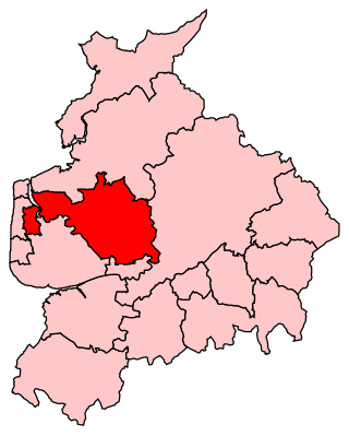
Wyre is a local government district with borough status on the coast of Lancashire, England. The council is based in Poulton-le-Fylde and the borough also contains the towns of Cleveleys, Fleetwood, Garstang, Preesall and Thornton, along with numerous villages and surrounding rural areas. Some of the borough's built-up areas form part of the wider Blackpool urban area. Eastern parts of the borough lie within the Forest of Bowland, a designated Area of Outstanding Natural Beauty.
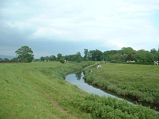
Poulton-le-Fylde, commonly shortened to Poulton, is a market town in Lancashire, England, situated on the coastal plain called the Fylde. In the 2021 United Kingdom census, it had a population of 18,115.
The River Wyre in Lancashire, England, flows into the Irish Sea at Fleetwood. It is 28 miles (45 km) long and has a sheltered estuary which penetrates deep into the Fylde peninsula.
Wyre and Preston North is a county constituency represented in the House of Commons of the Parliament of the United Kingdom. Created in the most recent fifth periodic review of constituencies by the Boundary Commission for England, it elects one Member of Parliament (MP) by the first past the post voting system.
Barton is a linear village and civil parish in the City of Preston, Lancashire, England. The parish had a population of 1,150, of whom 552 were male and 598 were female, according to the 2011 census.
Kirkland is a civil parish, located on the banks of the River Wyre, midway between Preston and Lancaster, in the English county of Lancashire. It is also the historic name of what is now the village of Churchtown, within the parish. It is part of the Wyre district. In 2001 the parish had a population of 343, decreasing to 314 at the 2011 census.
Hambleton is a village and civil parish in the English county of Lancashire. It is situated on a coastal plain called the Fylde and in an area east of the River Wyre known locally as Over Wyre. Hambleton lies approximately 3 miles (4.8 km) north-east of its post town, Poulton-le-Fylde, and about 7 miles (11 km) north-east of the seaside resort of Blackpool. In the 2001 United Kingdom census, the parish had a population of 2,678, increasing to 2,744 at the 2011 census.
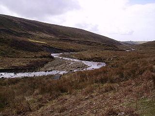
Pilling is a village and civil parish within the Wyre borough of Lancashire, England. It is 6.5 miles (10.5 km) north-northeast of Poulton-le-Fylde, 9.4 miles (15.1 km) south-southwest of Lancaster and 14.5 miles (23.3 km) northwest of Preston, in a part of the Fylde known as Over Wyre.
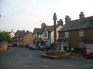
Catterall is a village and civil parish in the borough of Wyre, Lancashire, England. Historically in the Amounderness Hundred, it is situated on the A6 between Lancaster and Preston, a short distance from the town of Garstang, and Myerscough College. The rivers Wyre, Calder and Brock run through the parish and in places form the parish boundary.
Claughton is a sparse village and civil parish in the county of Lancashire in the north of England, in the Borough of Wyre. The population of the civil parish at the 2011 census was 633. It is sometimes called Claughton-on-Brock to distinguish it from another Claughton in Lancashire in the Lune valley between Lancaster and Hornby.
Stalmine-with-Staynall is a civil parish within the Wyre borough of Lancashire, England, in a part of the Fylde known as Over Wyre. The parish contains the village of Stalmine and the hamlets of Staynall and Wardley. The civil parish had a population of 1,486 at the 2011 Census, of which 1,087 lived in Stalmine village.
Great Eccleston is a village and civil parish in Lancashire, England situated on a coastal plain called the Fylde. The village lies to the south of the River Wyre and the A586 road, approximately 10 miles (16 km) upstream from Fleetwood. At the 2001 census, the parish had a population of 1,473, rising slightly to 1,486 at the 2011 census.
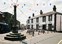
Cabus is a village and civil parish in Lancashire, England. It lies 12 miles north of Preston, 9 miles south of Lancaster and 16 miles north east of Blackpool.
The A586 is a road in England, which runs from Garstang to Blackpool, in Lancashire.
Inskip-with-Sowerby is a civil parish in the Borough of Wyre, in Lancashire, England. A part of the Fylde, the parish includes the village of Inskip and the hamlets Crossmoor to the west and Sowerby to the east. Also Inskip Moss Side lies about a mile north-west of the village at grid reference SD452391. In 2011 it had a population of 840.
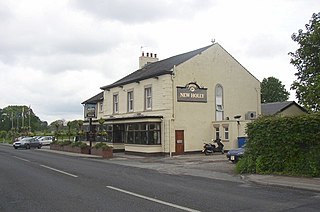
Forton is a village and civil parish in the Wyre district of the English county of Lancashire near the Forest of Bowland. It is near the A6 road, between the city of Lancaster and the town of Garstang. Its population as measured at the 2011 census is 1,213. It has one school, Forton Primary School, several churches and one pub, the New Holly.
Bilsborrow is a village and former civil parish, now in the parish of Myerscough and Bilsborrow, in the Wyre district, in the county of Lancashire, England. The village population at the 2011 census was 632. It is on the A6 road and the Lancaster Canal. It is approximately 1 mile (2 km) east of Myerscough.
Nether Wyresdale is a civil parish in Lancashire, England. In the 2001 United Kingdom census, it had a population of 613, rising to 655 at the 2011 census.
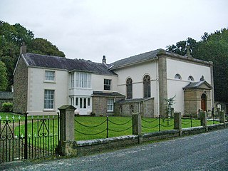
St Helen's Church is an Anglican church in the village of Churchtown in Lancashire, England. Historically, it was the parish church of Garstang; today, as Garstang is split into more than one ecclesiastical parish, St Helen's parish is Garstang St Helen (Churchtown). It is in the Diocese of Blackburn. It has been designated a Grade I listed building by English Heritage. St Helen's is known as the "cathedral of The Fylde".