Borough of Chorley

Last updated

Borough of Chorley
Town Hall, Chorley - geograph.org.uk - 2522957.jpg
War Memorial, Adlington - geograph.org.uk - 3433084.jpg
Crossroads in Eccleston - geograph.org.uk - 2121781.jpg
Whittle-le-Woods - geograph.org.uk - 2820635.jpg
Mossfield Nature Reserve, Buckshaw Village - panoramio (1).jpg
Chorley UK locator map.svg
Shown within Lancashire and England
Sovereign state United Kingdom
Constituent country England
Region North West England
Ceremonial county Lancashire
Founded 1 April 1974
Admin. HQ Chorley
Government
  TypeChorley Borough Council
   MPs: Lindsay Hoyle (Speaker) Katherine Fletcher
Area
  Total78.3 sq mi (202.8 km2)
  Rank 144th
Population
 (2021)
  Total117,937
  Rank Ranked 202nd
  Density1,500/sq mi (580/km2)
Ethnicity (2021)
[1]
   Ethnic groups
List
Religion (2021)
[1]
   Religion
List
Time zone UTC+0 (Greenwich Mean Time)
  Summer (DST) UTC+1 (British Summer Time)
Postcode areas
Area code(s) 01257, 01204, 01254, 01704, 01772
ISO 3166-2
ONS code 30UE (ONS)
E07000118 (GSS)
OS grid reference SD5817
NUTS 3
Ethnicity95.1% White British
1.6% Asian [2]

The Borough of Chorley is a local government district with borough status in Lancashire, England. It is named after the town of Chorley, which is an unparished area. The borough extends to several villages and hamlets including Adlington, Buckshaw Village, Croston, Eccleston, Euxton and Whittle-le-Woods.

Contents

The neighbouring districts are West Lancashire, South Ribble, Blackburn with Darwen, Bolton and Wigan.

History

The town of Chorley had been governed by improvement commissioners from 1853. [3] The commissioners were reconstituted as a local board in 1863. [4] The board was in turn replaced in 1881 when the town was made a municipal borough. [5]

The modern district was created on 1 April 1974 under the Local Government Act 1972, covering the area of four former districts, which were all abolished at the same time: [6]

The new district was named Chorley, and the borough status previously held by the town was passed to the new district on the day that it came into being, allowing the chair of the council to take the title of mayor, continuing Chorley's series of mayors dating back to 1881. [7] [8]

Governance

Chorley Council
Chorley Council logo.svg
Type
Type
History
Founded1 April 1974
Leadership
Tommy Gray,
Labour
since 16 May 2023 [9]
Alistair Bradley,
Labour
since 15 May 2012
Chris Sinnott
since January 2023 [10]
Structure
Seats42 councillors
Political groups
Administration (37)
  Labour (37)
Opposition (5)
  Conservative (5)
Elections
First past the post
Last election
4 May 2023
Next election
2 May 2024
Meeting place
Chorley Town Hall - geograph.org.uk - 4201533.jpg
Town Hall, Market Street, Chorley, PR7 1DP
Website
www.chorley.gov.uk

Chorley Borough Council, which styles itself "Chorley Council", provides district-level services. County-level services are provided by Lancashire County Council. Much of the borough is also covered by civil parishes, which form a third tier of local government. [11]

Political control

The council has been under Labour majority control since 2012.

The first election to the reformed borough council was held in 1973, initially operating as a shadow authority alongside the outgoing authorities before coming into its powers on 1 April 1974. Political control of the council since 1974 has been as follows: [12]

Party in controlYears
No overall control 1974–1976
Conservative 1976–1983
No overall control 1983–1990
Labour 1990–1991
No overall control 1991–1995
Labour 1995–2000
No overall control 2000–2006
Conservative 2006–2011
No overall control 2011–2012
Labour 2012–present

Leadership

The role of mayor is largely ceremonial in Chorley. Political leadership is instead provided by the leader of the council. The leaders since 1990 have been: [13]

CouncillorPartyFromTo
Jack Wilson Labour 199016 May 2006
Peter Goldsworthy Conservative 16 May 200615 May 2012
Alistair Bradley Labour 15 May 2012

Composition

Following the 2023 election and a by-election in September 2023, the composition of the council was: [14] [15]

PartyCouncillors
Labour 37
Conservative 5
Total42

The next election is due in 2024.

Elections

Since the last boundary changes in 2020 the council has comprised 42 councillors representing 14 wards, with each ward electing three councillors. Elections are held three years out of every four, with a third of the council (one councillor for each ward) elected each time for a four year term of office. Lancashire County Council elections are held in the fourth year of the cycle when there are no borough council elections. [16]

The wards are:

  1. Adlington & Anderton
  2. Buckshaw & Whittle
  3. Chorley East
  4. Chorley North East
  5. Chorley North West
  6. Chorley North & Astley
  7. Chorley South East & Heath Charnock
  8. Chorley South West
  9. Clayton East, Brindle & Hoghton
  10. Clayton West & Cuerden
  11. Coppull
  12. Croston, Mawdesley & Euxton South
  13. Eccleston, Heskin & Charnock Richard
  14. Euxton

The Chorley constituency was coterminous with the borough from 1997 until 2010 when Croston, Eccleston, Bretherton and Mawdesley were transferred to the South Ribble constituency. The current Member of Parliament for Chorley is Lindsay Hoyle, who was first elected to the seat in 1997.

Premises

Civic Offices, Union Street Chorley Council.JPG
Civic Offices, Union Street

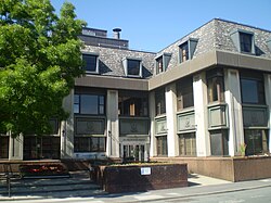
The council's main offices are at the Civic Offices on Union Street in Chorley. [17] Council meetings are held at Chorley Town Hall on Market Street, which had been completed in 1879 for the old local board. [18] [19] [20]

Parishes

Parishes in Chorley Borough Borough of Chorley parishes map.svg
Parishes in Chorley Borough

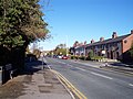
The borough contains 23 civil parishes. The parish council for Adlington takes the style "town council". [21] The central part of the borough, roughly corresponding to the pre-1974 borough of Chorley, is an unparished area. [22]

  1. Adlington
  2. Anderton
  3. Anglezarke
  4. Astley Village
  5. Bretherton
  6. Brindle
  7. Charnock Richard
  8. Clayton-le-Woods
  9. Coppull
  10. Croston
  11. Cuerden
  12. Eccleston
  13. Euxton
  14. Heapey
  15. Heath Charnock
  16. Heskin
  17. Hoghton
  18. Mawdesley
  19. Rivington
  20. Ulnes Walton
  21. Wheelton
  22. Whittle-le-Woods
  23. Withnell

Settlements

Freedom of the Borough

The following people and military units have received the Freedom of the Borough of Chorley.

Individuals

[23]

Military Units

Related Research Articles

<span class="mw-page-title-main">Chorley</span> Town in Lancashire, England

Chorley is a town and the administrative centre of the wider Borough of Chorley in Lancashire, England, 8 miles (13 km) north of Wigan, 11 miles (18 km) south west of Blackburn, 11 miles (18 km) north west of Bolton, 12 miles (19 km) south of Preston and 20 miles (32 km) north west of Manchester. The town's wealth came principally from the cotton industry.

<span class="mw-page-title-main">Euxton</span> Human settlement in England

Euxton is a village and civil parish of the Borough of Chorley, in Lancashire, England. The population of the civil parish as taken at the 2011 census was 9,993, however, the population is now estimated to be around 14,000 due to the increase in housing developments in the village, including the Buckshaw development. The village is situated just to the west of Chorley, and to the south of Clayton-le-Woods.

<span class="mw-page-title-main">Chorley (UK Parliament constituency)</span> Parliamentary constituency in the United Kingdom, 1885 onwards

Chorley is a constituency in Lancashire represented in the House of Commons of the UK Parliament since 1997 by Lindsay Hoyle. Hoyle was originally elected for the Labour Party, but in 2019 became the Speaker, making him unaffiliated.

<span class="mw-page-title-main">South Ribble (UK Parliament constituency)</span> Parliamentary constituency in the United Kingdom, 1983 onwards

South Ribble is a constituency represented in the House of Commons of the UK Parliament since 2019 by Katherine Fletcher, a Conservative.

<span class="mw-page-title-main">Eccleston, Lancashire</span> Village and civil parish in England

Eccleston is a village and civil parish of the Borough of Chorley in Lancashire, England. It is beside the River Yarrow, and was formerly an agricultural and later a weaving settlement.

<span class="mw-page-title-main">Clayton-le-Woods</span> Human settlement in England

Clayton-le-Woods is a large village and civil parish of the Borough of Chorley, in Lancashire, England. According to the census of 2001, it has a population of 14,528. At the 2011 census the population of Cuerden civil parish was included within Clayton-le-Woods, giving a total of 14,532.

<span class="mw-page-title-main">Clayton Brook</span> Human settlement in England

Clayton Brook is a large residential estate in Lancashire, between the city of Preston and the town of Chorley. It forms part of the Clayton-le-Woods civil parish, and is in the Clayton-le-Woods North ward of the borough of Chorley.

<span class="mw-page-title-main">Buckshaw Village</span> Residential and industrial area in Lancashire, England

Buckshaw Village is a 21st-century residential and industrial area between the towns of Chorley and Leyland in Lancashire, England, developed on the site of the former Royal Ordnance Factory (ROF) Chorley. It had a population of 4,000. It is divided between the civil parishes of Euxton (south) and Whittle-le-Woods in Chorley, with the north western part being in Leyland unparished area in South Ribble district.

<span class="mw-page-title-main">River Yarrow (Lancashire)</span> River in Lancashire, England

The River Yarrow is in Lancashire, with its source at an area called Will Narr at Hordern Stoops, along Spitlers Edge - the Chorley/Blackburn boundary - on the West Pennine Moors. The river feeds the Yarrow Reservoir, which in turn feeds the Anglezarke and Upper and Lower Rivington Reservoirs. Upon leaving the reservoirs via a pumping station, the river passes through an area that was formerly known as Abyssinia. Currently, this area is within the boundaries of Heath Charnock and Limbrick, but the original name was given because it was a route frequented by coal miners, and the workers were said to look like natives of Abyssinia : until the mid 20th century it was usual for miners to return from work covered in coal dust.

<span class="mw-page-title-main">Diocese of Blackburn</span> Diocese of the Church of England

The diocese of Blackburn is diocese of the Church of England in North West England. Its boundaries correspond to northern Lancashire with the exception of the eastern part of the Forest of Bowland, which is part of the diocese of Leeds. The diocese contains 211 parishes and 280 churches. Blackburn Cathedral is the seat of the bishop of Blackburn, currently Philip North, and the diocesan offices are also located in Blackburn.

<span class="mw-page-title-main">Chorley Borough Council elections</span> Elections in Lancashire

Chorley Borough Council elections are generally held three years out of every four, with a third of the council elected each time. Chorley Borough Council is the local authority for the non-metropolitan district of Chorley in Lancashire, England. Since the last boundary changes in 2020, 42 councillors have been elected from 14 wards.

<span class="mw-page-title-main">Blue Bus of Penwortham</span>

Blue Bus was a bus operator based in Penwortham, Lancashire. It operated many routes, including services to Preston City Centre.

Chorley Interchange is a bus station in Chorley, England.

<span class="mw-page-title-main">Listed buildings in Lancashire</span>

There are a number of listed buildings in Lancashire. The term "listed building", in the United Kingdom, refers to a building or structure designated as being of special architectural, historical, or cultural significance. Details of all the listed buildings are contained in the National Heritage List for England. They are categorised in three grades: Grade I consists of buildings of outstanding architectural or historical interest, Grade II* includes significant buildings of more than local interest and Grade II consists of buildings of special architectural or historical interest. Buildings in England are listed by the Secretary of State for Culture, Media and Sport on recommendations provided by English Heritage, which also determines the grading.

Chorley Rural District was a rural district in the administrative county of Lancashire, England from 1894 to 1974.

<span class="mw-page-title-main">Coat of arms of Chorley</span> English coats of arms

The coat of arms of the Borough of Chorley was granted along with borough status in 1882.

References

  1. 1 2 UK Census (2021). "2021 Census Area Profile – Chorley Local Authority (E07000118)". Nomis. Office for National Statistics . Retrieved 5 January 2024.
  2. UK Census (2011). "Local Area Report – Chorley Local Authority (E07000118)". Nomis. Office for National Statistics . Retrieved 26 March 2021.
  3. "Chorley Improvement Act 1853". legislation.gov.uk. The National Archives. Retrieved 5 October 2023.
  4. "No. 22786". The London Gazette . 6 November 1863. p. 5240.
  5. "Chorley Municipal Borough". A Vision of Britain through Time. GB Historical GIS / University of Portsmouth. Retrieved 5 October 2023.
  6. "The English Non-metropolitan Districts (Definition) Order 1972", legislation.gov.uk , The National Archives, SI 1972/2039, retrieved 22 August 2022
  7. "The English Non-metropolitan Districts (Names) Order 1973", legislation.gov.uk , The National Archives, SI 1973/551, retrieved 22 August 2022
  8. "District Councils and Boroughs". Parliamentary Debates (Hansard) . 28 March 1974. Retrieved 16 January 2012.
  9. "Council minutes, 16 May 2023". Chorley Council. Retrieved 5 October 2023.
  10. Aldred, Tim (22 April 2022). "Chorley Council and South Ribble Borough Council appoint shared chief executive". Lancashire Business View. Retrieved 5 October 2023.
  11. "Local Government Act 1972", legislation.gov.uk , The National Archives, 1972 c. 70, retrieved 31 May 2023
  12. "Compositions calculator". The Elections Centre. Retrieved 14 May 2023.
  13. "Council minutes". Chorley Borough Council. Retrieved 26 August 2022.
  14. "Local elections 2023: live council results for England". The Guardian.
  15. Faulkner, Paul (15 September 2023). "Chorley by-elections: Labour leader says party's county win points to 'red tsunami' in Lancashire at the general election". Lancashire Post. Retrieved 5 October 2023.
  16. "The Chorley (Electoral Changes) Order 2019", legislation.gov.uk , The National Archives, SI 2019/1124, retrieved 5 October 2023
  17. "Other ways to get in touch". Chorley Borough Council. Retrieved 26 August 2022. Our address is: Civic Offices, Union Street, Chorley, Lancashire, PR7 1AL
  18. "Executive Cabinet agenda, 14 July 2022". Chorley Borough Council. 14 July 2022. Retrieved 26 August 2022. Venue: Council Chamber, Town Hall, Chorley
  19. "1875 – Town Hall, Chorley, Lancashire". Archiseek. Retrieved 28 November 2020.
  20. "Chorley, Lancashire". The Comprehensive Gazetteer of England & Wales, 1894-5. Retrieved 28 November 2020.
  21. "Parish councils contact information". Chorley Council. Retrieved 5 October 2023.
  22. "Election Maps". Ordnance Survey. Retrieved 5 October 2023.
  23. 1 2 Clewlow, Stuart (7 October 2021). "The Freedom of Chorley: Who were the people granted this title and were they really allowed to have grazing rights in the town?". The Chorley Guardian. Retrieved 24 October 2021.
  24. "Freedom of the Borough 2017". Government of the United Kingdom.
  25. "3 Medical Regiment to be presented with the Freedom of the Borough". Chorley Council. 26 May 2015. Retrieved 9 December 2020.

53°39′11″N2°37′55″W / 53.653°N 2.632°W / 53.653; -2.632