River Roddlesworth

Last updated

The upper reaches of the river near Roddlesworth River Roddlesworth - geograph.org.uk - 1322947.jpg
The upper reaches of the river near Roddlesworth

The River Roddlesworth (also known as Rocky Brook) is a river in Lancashire, England, a tributary of the River Darwen.

Contents

Course

The source of the river is on the slopes of Great Hill, just above the ruins known as Pimm's, where the infant river is known as Calf Hey Brook. Calf Hey Brook is joined by another stream occasionally termed Roddlesworth - which rises beneath Cartridge Hill and runs past the ruins of Hollinshead Hall - beneath Slipper Lowe.

From there, it follows a northerly course through Roddlesworth Plantations, around the two reservoirs fed by the river and past Red Lees. The river continues through the Stanworth Valley in Livesey, where it is met by Stockclough Brook, and under the M65 motorway and Leeds & Liverpool Canal. Stanworth Valley was the location for some of the No M65 Road Protest camps . This was the site of a 5-day eviction in 1995, between environmentalists and road builders. At stake was the ecologically valuable river system and diverse woodland. M65 motorway archive

Soon after this, the Roddlesworth enters a culvert close to the Star Paper Mill.

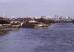
The Roddlesworth flows into the River Darwen at Moulden Brow. Between the confluence with Stockclough Brook and the Darwen, the river is known locally as Moulden (or Moulding) Water.

For virtually its entire course, the Roddlesworth marks the boundary between Chorley Borough and the unitary authority of Blackburn with Darwen.

This border was preceded by that between the Hundreds of Blackburn and Leyland.

The river also demarcated the eastern edge of the region of Gunolfesmores in the Middle Ages and, later, the Manor of Hoghton. [1]

The name is first recorded in about 1160 as Rodtholfeswrtha, suggesting a derivation meaning "the homestead of Hrothwulf". [2]

Settlements

The Roddlesworth runs through a wooded valley close to the settlements of Tockholes, Roddlesworth, Abbey Village and Stanworth before joining the River Darwen close to Feniscowles.

Reservoirs

Tributaries

Finnington Brook joins close to where the Roddlesworth itself falls into the River Darwen. Rising from the confluence of several small brooks, draining Riley Green , Marsh View and Brimmicroft, which meet close to Riley Green Bridge over the Leeds and Liverpool Canal, the brook runs eastward in a small, wooded valley below the canal. The river flows by the hamlet of Finnington, picking up other streams heading north from Stanworth, running by a hatchery and through a reservoir, joining the Roddlesworth on the south side of Moulden Water Bridge.

Stockclough Brook flows into the Roddlesworth in the Stanworth Valley, opposite the site of what was probably once a small mill. The brook rises close to Potter's and flows west and south west, skirting by Lower Whitehalgh Farm before passing beneath Stockclough Lane and the M65 Motorway. Whitehalgh Brook joins near stepping stones in Owlet Holes Wood before Stockclough Brook flows beneath the Stockclough Viaduct, over which the former railway between Cherry Tree and Chorley once ran, before joining the Roddlesworth. Whitehalgh Brook itself rises in Adam Plat Wood where three brooks from Tockholes combine. Sheep Bridge Brook rises near Tithe Barn Cottages and flows northwest towards Yew Tree Farm, before moving southwest through Hole Bottom Wood, where it flows beneath the bridge that gives the stream its name. It meets Chapels Brook, flowing northwest from Close Farm and Weasel Farm in Tockholes, following Rock Lane to Chapels Farm, after which it moves past Pickering Fold and through Heald Wood. Shaw Brook joins at the western end of Adam Plat Wood, having run west and north from its source on Green Hill, via Golden Soney Farm and Lower Hill, past Higher Crow Trees Farm and Lower Crow Trees Farm passing through a wooded vale to its confluence with Whitehalgh Brook.

Rake Brook rises at Brown Hill on Withnell Moor and flows northward, draining the west side of Cold Within Hill before pouring through Birch Clough, separating Twist Moor and Roddlesworth Moor and feeding Rake Brook Reservoir, formerly populated by Rake Wood. The confluence of Rake Brook and the River Roddlesworth is in Benson's Wood, just after the end of the overflow from the Roddlesworth Reservoirs. Rake Brook Reservoir is also fed by another stream rising on Withnell Moor. This unnamed brook flows north, separating Withnell Moor from Wheelton Moor (as well as the two civil parishes) before passing the ruins of New Temple (just south of Solomon's Temple), Summer House (formerly known as Botany Bay) and Pope's, running east of Millstone Edge, before meeting Rake Brook.

Related Research Articles

River Douglas, Lancashire River in north-west England

The River Douglas, also known as the River Asland or Astland, flows through parts of Lancashire and Greater Manchester in North West England. It is a tributary of the River Ribble and has several tributaries, the major ones being the River Tawd and the River Yarrow.

River Tame, West Midlands River in the West Midlands of England

For the river in Greater Manchester, see River Tame, Greater Manchester.

River Blakewater, Lancashire River in Lancashire, England

The River Blakewater is a river running through Lancashire, giving its name to the town of Blackburn.

River Darwen River in Lancashire, England

The River Darwen runs through Darwen and Blackburn in Lancashire, England, eventually joining the River Ribble at Walton le Dale south of Preston on its way to the Ribble Estuary.

River Dwyryd River in Gwynedd, Wales

The River Dwyryd is a river in Gwynedd, Wales which flows principally westwards; draining to the sea into Tremadog Bay, south of Porthmadog.

Water of Leith (New Zealand) River in Dunedin, New Zealand

The Water of Leith, is a small river in the South Island of New Zealand.

Belmont, Lancashire Human settlement in England

Belmont is a village in Lancashire, England. It is close to Darwen. It has around 500 inhabitants and lies within the civil parish of North Turton in the unitary authority area of Blackburn with Darwen.

West Pennine Moors

The West Pennine Moors is an area of the Pennines covering approximately 90 square miles (230 km2) of moorland and reservoirs in Lancashire and Greater Manchester, England. It is a Site of Special Scientific Interest.

River Calder, Lancashire River in Lancashire, England

The River Calder is a major tributary of the River Ribble in Lancashire, England and is around 20 miles (32 km) in length.

Tockholes Human settlement in England

Tockholes is a village and civil parish which forms part of the Blackburn with Darwen unitary authority in the English county of Lancashire, England. Tockholes consists of the village of Tockholes itself and the hamlet of Ryal Fold, and has a population of 454, increasing to 478 at the 2011 Census. It lies on the West Pennine Moors and is surrounded by the towns of Blackburn to the north and Darwen to the east and by the villages of Belmont to the south and Withnell to the west. Darwen Tower is a prominent local landmark that lies to the east of Tockholes and the Roddlesworth Reservoirs and Tockholes forest plantation lie to the south with the M65 passing to the north. There are two churches: Tockholes United Reformed Church and Saint Stephen's Church.

River Lostock River in Lancashire, England

The River Lostock is a river in Lancashire, England.

Lower Roddlesworth Reservoir

Lower Roddlesworth Reservoir is a reservoir on the River Roddlesworth close to Abbey Village in Lancashire, England.

Stydd Brook Watercourse in Lancashire, England

Stydd Brook is a watercourse in Lancashire, England.

Dinckley Brook

Dinckley Brook is a minor river of Lancashire, England. The stream rises at the confluence of several minor watercourses at Wheatley Farm close to Copster Green and flows northwards, through Cunliffe House Wood and under Dinckley Bridge. The brook continues past Brockhall, Great Wood and Bradyll, continuing past the Brockhall training base of Blackburn Rovers and through Mill Wood. Soon afterwards, Dinckley Brook falls into the River Ribble.

River Rye, Yorkshire River in North Yorkshire, England

The River Rye in the English county of North Yorkshire rises just south of the Cleveland Hills, east of Osmotherley, and flows through Hawnby, Rievaulx, Helmsley, Nunnington, West and East Ness, Butterwick, Brawby, and Ryton, before joining the River Derwent at 54°10′N00°44′W near Malton.

Skirden Beck Minor river in Lancashire, England

Skirden Beck is a minor river in Lancashire, England. It is approximately 4.3 miles (6.85 km) long and has a catchment area of 18.87 square miles (48.882 km2).

Piethorne Brook Stream in Greater Manchester, England

Piethorne Brook is a watercourse in Greater Manchester. It is a tributary of the River Beal.

Alden Valley Human settlement in England

The Alden Valley is a small valley on the eastern edge of the West Pennine Moors, west of Helmshore in Rossendale, Lancashire, England. In the 14th century it was part of the Earl of Lincoln's hunting park. By 1840 it was home to about twenty farms, largely involved in cattle rearing, although most inhabitants were also involved with the production of textiles, which quickly developed during the Industrial Revolution into the building of textile mills. These have now been demolished and the valley is dominated by sheep grazing, with three working farms and a number of smallholdings.

Hameldon Hill

Hameldon Hill is a Carboniferous sandstone hill with a summit elevation of 409 metres (1,342 ft), situated between the towns of Burnley and Accrington in Lancashire, England. It is listed as a "HuMP" or "Hundred Metre Prominence", its parent being Freeholds Top, a Marilyn near Bacup.

Breakneck Brook

Breakneck Brook, sometimes Breakneck Valley Brook, is a 1.7-mile-long (2.8 km) tributary of the Hudson River located entirely in the Putnam County town of Philipstown, New York, United States. It rises at Surprise Lake and flows southwest towards the Hudson from there, mostly through Hudson Highlands State Park. The name comes from Breakneck Ridge to its north.

References

  1. Lofthouse, J. (1951) Lancashire Landscape. Robert Hale Ltd., London, page 92.
  2. Ekwall, E. (1922) The Place-names of Lancashire. Longmans, Green & Company, page 132.

Coordinates: 53°43′23″N2°32′45″W / 53.7230°N 2.5459°W / 53.7230; -2.5459