
The River Douglas, also known as the River Asland or Astland, flows through parts of Lancashire and Greater Manchester in North West England. It is a tributary of the River Ribble and has several tributaries, the major ones being the River Tawd and the River Yarrow.

The River Taff is a river in Wales. It rises as two rivers in the Brecon Beacons; the Taf Fechan and the Taf Fawr before becoming one just north of Merthyr Tydfil. Its confluence with the River Severn estuary is in Cardiff.

Horwich is a town and civil parish in the Metropolitan Borough of Bolton, Greater Manchester, England. Prior to 1974 in the historic county of Lancashire. It is 5.3 miles (8.5 km) southeast of Chorley, 5.8 miles (9.3 km) northwest of Bolton and 15 miles (24 km) northwest of Manchester. It lies at the southern edge of the West Pennine Moors with the M61 motorway passing close to the south and west. At the 2011 Census, Horwich had a population of 20,067.

Hollingworth Lake is a 130-acre (53 ha) reservoir at Smithy Bridge in Littleborough, Greater Manchester, England. It was originally built as the main water source for the Rochdale Canal, but developed as a tourist resort from the 1860s. Hotels were built around it, helped by the arrival of the railway in 1839, which brought day-trippers and weekend visitors from Manchester, Bradford and Leeds.

Anglezarke is a sparsely populated civil parish in the Borough of Chorley in Lancashire, England. It is an agricultural area used for sheep farming, also site of reservoirs that were built to supply water to Liverpool. The area has a large expanse of moorland with many public footpaths and bridleways. The area is popular with walkers and tourists, it lies in the West Pennine Moors in Lancashire, sandwiched between the moors of Withnell and Rivington, and is close to the towns of Chorley, Horwich and Darwen. At the 2001 census it had a population of 23. At the 2011 Census the population is included within Heapey civil parish. The area was subjected to depopulation after the reservoirs were built.

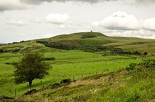
Rivington Pike is a hill on Winter Hill, part of the West Pennine Moors at Rivington, Chorley in Lancashire, England. The nearest towns are Adlington and Horwich. The land and building are owned and managed by Chorley Council. The Pike Tower is a prominent local landmark and is located at the summit, it is part of Lever Park. The area is popular with hill walkers and for mountain biking.

Anderton is a civil parish in the Borough of Chorley in Lancashire, England. It is now a suburb of Adlington, 5 miles (8 km) northwest of Bolton. Within its boundaries are the Rivington Reservoirs. Grimeford village is in the parish. In 2001, the parish had a population of 1,206, increasing to 1,316 at the 2011 census.
Rivington is a village and civil parish of the Borough of Chorley, Lancashire, England, occupying 2,538 acres. It is about 6 miles (9.7 km) southeast of Chorley and about 8+1⁄2 miles (13.7 km) northwest of Bolton. Rivington is a rural area consisting primarily of agricultural grazing land, moorland, with hill summits including Rivington Pike and Winter Hill within the West Pennine Moors. The area has a thriving tourist industry centred around reservoirs created to serve Liverpool in the Victorian era and Lever Park created as a public park by William Lever at the turn of the 20th century, with two converted barns, a replica of Liverpool Castle and open countryside. Rivington and Blackrod High School is located here. Rivington and its village had a population of 109 at the 2011 Census.

The West Pennine Moors is an area of the Pennines covering approximately 90 square miles (230 km2) of moorland and reservoirs in Lancashire and Greater Manchester, England. It is a Site of Special Scientific Interest.

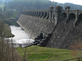
Anglezarke Reservoir is the largest reservoir in the Rivington chain to the west of Anglezarke in Lancashire, England. Anglezarke Reservoir has three embankments: the Charnock Embankment, the longest, is 850 yards (777 m) long and 31 feet (9.45 m) high, the Knowsley Embankment is 240 yards (219.5 m) long and 45 feet (14 m) high and the Heapey Embankment is 280 feet (85.3 m) long and 32 feet (9.75 m) high. It is fed by the River Yarrow, which has been diverted from its original course which is now covered by the Knowsley Embankment. It served the city of Liverpool before its current status as a supply mainly for Wigan. The original `Rivington Pike Scheme' was undertaken by Thomas Hawksley between 1850 and 1857 for the Liverpool Corporation Waterworks. The scheme was to construct five reservoirs and a water treatment works at the south end of Lower Rivington with a 17-mile (27 km) pipeline to storage reservoirs at Prescot. Water from two higher level reservoirs, Rake Brook and Lower Roddlesworth, was carried south in `The Goit', a channel connecting them to the reservoirs.

Langsett Reservoir is in Yorkshire, England, near the villages of Langsett and Upper Midhope, on the edge of the Peak District National Park. The reservoir was constructed between 1898 and 1904, and is now managed by Yorkshire Water. Fed by the Little Don or Porter River, it is around a mile long, and supplies water for Sheffield and Barnsley via the Langsett Treatment Works.

Rivington Water Treatment Works is a water treatment plant in Rivington, Lancashire, England. It is located below the Lower Rivington Reservoir, the last in the Rivington chain of reservoirs. The first treatment works, a slow-sand filter plant on the site opened in 1860, supplying water to Liverpool. The present works was built in 1994, and in 2007 was the largest automated three-stage plant operated by United Utilities, the water is now disinfected by adding small amounts of chlorine. Most of its output supplies customers in the Wigan area.

Yarrow Reservoir - named after the River Yarrow - is a reservoir in the Rivington chain in Anglezarke, Lancashire, England, and has a storage capacity second to Anglezarke Reservoir. Construction of the reservoir, designed by Liverpool Borough Engineer Thomas Duncan, began in 1867.

Upper Rivington Reservoir is situated centrally in the Rivington chain of reservoirs, on the West Pennine Moors in Lancashire, England, between Rivington and Anglezarke. The engineer for the Rivington reservoirs was Thomas Hawksley and construction for Liverpool Corporation Waterworks took place between 1852 and 1857. The two dams of the Upper Rivington reservoir are the 292-yard (267 m) Horrobin Embankment that separates it from the lower reservoir and carries a road into the village from the west, and the 292-yard (267 m) long, 40 foot (12.2 m) high Yarrow Embankment.
Upper Roddlesworth Reservoir is a reservoir on the River Roddlesworth near Abbey Village in Lancashire, England.

The William Girling Reservoir is located in the London Borough of Enfield and is part of the Lee Valley Reservoir Chain that supplies London with drinking water. It is named after William Girling OBE, a chairman of the Metropolitan Water Board (MWB). The reservoir and the nearby King George V Reservoir are known collectively as the Chingford Reservoirs. The storage reservoir, which is owned by Thames Water, is bordered by Chingford to the east and Ponders End and Edmonton to the west, and covers 334 acres with a perimeter of 3.5 miles (5.6 km). There is no public access.

Heath Charnock is a small village and civil parish of the Borough of Chorley in Lancashire, England. According to the United Kingdom Census 2001 it has a population of 2,065, reducing to 2,026 at the 2011 Census.

Walka Water Works is a heritage-listed 19th-century pumping station at 55 Scobies Lane, Oakhampton Heights, City of Maitland, New South Wales, Australia. Originally built in 1887 to supply water to Newcastle and the lower Hunter Valley, it has since been restored and preserved and is part of Maitland City Council's Walka Recreation and Wildlife Reserve. It was added to the New South Wales State Heritage Register on 2 April 1999.

Rivington Church is an active Anglican parish church in Rivington, Lancashire, England. It is in the Deane deanery, the Bolton archdeanery and Diocese of Manchester. The church has been designated a Grade II listed building. The church has no patron saint and is not named after a saint or martyr. It has been variously called St Lawrence, St George, Holy Trinity, and St Catherine but its correct title is Rivington Church.
Liverpool Corporation Waterworks and its successors have provided a public water supply and sewerage and sewage treatment services to the city of Liverpool, England. In 1625 water was obtained from a single well and delivered by cart, but as the town grew, companies supplied water to homes through pipes. There were two main companies by the 1840s, but the water supply was intermittent, and there was general dissatisfaction with the service. Liverpool Corporation decided that such an important service should be provided by a public body, and sought to take over the water supply companies.

