The River Yarrow is in Lancashire, with its source at an area called Will Narr at Hordern Stoops, along Spitlers Edge - the Chorley/Blackburn boundary - on the West Pennine Moors. The river feeds the Yarrow Reservoir, which in turn feeds the Anglezarke and Upper and Lower Rivington Reservoirs. Upon leaving the reservoirs via a pumping station, the river passes through an area that was formerly known as Abyssinia. Currently, this area is within the boundaries of Heath Charnock and Limbrick, but the original name was given because it was a route frequented by coal miners, and the workers were said to look like natives of Abyssinia (modern day Ethiopia): until the mid 20th century it was usual for miners to return from work covered in coal dust.[1]
The Croston Flood Risk Management Scheme involved the construction of a dam on the River just east of Eccleston. The dam was constructed to protect over 300 properties in Croston and Eccleston from flooding. The dam was proposed after the 2012 floods which flooded over 200 properties in Croston. Construction had already commenced when the 2015 boxing day floods caused over 300 properties in Croston and Eccleston to flood. This consequently meant that the construction suffered a major delay due to unworkable ground conditions as a result of the floods. The dam was finally completed in July 2017 at a cost of £7 million, £5.4 million in Government Grant in Aid funding, £1 million from Chorley Council, £181,000 from Lancashire County Council and £667,000 was received from local levy. The dam works by monitoring the river level in croston and either lowers or raises gates to control the flow of water. A Large bank was constructed to hold excess water back. The scheme has so far proved successful at protecting Croston and Eccleston from flooding.[2]
Etymology
The name Yarrow is obscure,[3] and there are multiple explanations as to the origin of the name. It may have the same origin as the River Yarrow in Selkirkshire in Scotland,[3] and therefore be derived from the Brittonic element garw, meaning "rough, harsh, rugged, uncultivated".[3] However, it may also be related to the River Arrow in Warwickshire (Brittonic *ar-w-ā-),[3] and derived either from Brittonic *ar, an ancient river-name element implying either horizontal motion, "flowing", or else "rising" or "springing up",[3] or *arβ, *arw, found in the Celtic languages as Welshirfin and Bretonirvin, both meaning "a wild turnip".[3] A relationship with the River Arrow in the Welsh marches is also possible,[3] deriving therefore from a form of Brittonic arɣant, meaning "silver, white, bright".[3][4]
Wildlife
After suffering many years of pollution due to effluent discharge from Whitter's factory and Stanley's factory, the river is now much cleaner, and as such has attracted birds such as dippers, grey wagtails and kingfishers, and fish including trout, chub, Dace and barbel.
Fish passes have been installed at Pincock, Birkacre and Duxbury, to enable upstream spawning of fish which would be unable to navigate the weirs. Salmon have been recorded at Duxbury for the first time in over 100 years.[5]
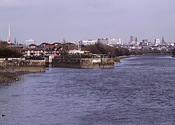
The source of the river at the base of Will Narr, Hordern Stoops, Lancashire. At the top of the picture are the slopes of Winter HillBlack Brook - a tributary at White CoppiceShortly after departing the reservoirs, the river passes through an area of Chorley formerly known as Abyssinia
Locations that are listed on Ordnance Survey maps are italicised:
Green Withins Brook— near to the ruins of Simm's Farm. It starts at Standing Stones Hill.
Limestone Brook— has its source near to Devils Ditch, and flows via Shooting Huts on Anglezarke Moor where it joins at the Meeting of the Waters.
Black Brook— flows from Great Hill through White Coppice (where it is known as Warth Brook), and lesserly from Eagle Tower at Heapey. The brook joins the river at the Yarrow Bridge prior to entering Duxbury Woods. The brook has today more flow than the Yarrow, due to the large amount of water removed from the Yarrow for consumption. In fact, the Yarrow flooded when Anglezarke Reservoir was drained in 2002, waterlogging the fields at Nick Hilton's Bridge.
Eller Brook—partial offtake, between Duxbury Woods and Drybones (off Burgh Lane) from Adlington
Clancutt Brook— flows away from the sea, and feeds in at Birkacre near Coppull.
The Environment Agency measure the water quality of the river systems in England. Each is given an overall ecological status, which may be one of five levels: high, good, moderate, poor and bad. There are several components that are used to determine this, including biological status, which looks at the quantity and varieties of invertebrates, angiosperms and fish, and chemical status, which compares the concentrations of various chemicals against known safe concentrations. Chemical status is rated good or fail.[6]
The water quality of the River Yarrow system was as follows in 2016. Reasons for the quality being less than good include sewage discharge, physical modification of the channel and poor nutrient management of agricultural land.
↑Nye, M.; Tapsell, S.; Twigger-Ross, C. (9 October 2011). "New social directions in UK flood risk management: moving towards flood risk citizenship?". Journal of Flood Risk Management. 4 (4): 288–297. doi:10.1111/j.1753-318x.2011.01114.x. ISSN1753-318X.
This page is based on this Wikipedia article Text is available under the CC BY-SA 4.0 license; additional terms may apply. Images, videos and audio are available under their respective licenses.