South Ribble

Last updated

South Ribble
Leyland Motors Clock, Hough Lane, Leyland - geograph.org.uk - 2290100.jpg
Station Road, Bamber Bridge - geograph.org.uk - 5626668.jpg
Pleasant Lostock Hall (cropped).jpg
Penwortham Parish Church - geograph.org.uk - 2815227.jpg
South Ribble Borough Council offices - geograph.org.uk - 3324827.jpg
South Ribble UK locator map.svg
Shown within the ceremonial county of Lancashire
Sovereign state United Kingdom
Constituent country England
Region North West England
Ceremonial county Lancashire
Founded1 April 1974
Admin. HQ Leyland
Government
  TypeSouth Ribble Borough Council
   MPs: Katherine Fletcher, Nigel Evans
Area
  Total43.7 sq mi (113.1 km2)
  Rank 183rd
Population
 (2021)
  Total111,204
  Rank Ranked 215th
  Density2,500/sq mi (980/km2)
Time zone UTC+0 (Greenwich Mean Time)
  Summer (DST) UTC+1 (British Summer Time)
ONS code 30UN (ONS)
E07000126 (GSS)
Ethnicity97.1% White
1.5% S. Asian [1]
South Ribble Borough Council
South Ribble Borough Council logo.svg
Type
Type
Leadership
Chris Lomax,
Labour
since 24 May 2023 [2]
Paul Foster,
Labour
since 15 May 2019 [3]
Chris Sinnott
since January 2023 [4]
Structure
Seats50 councillors
UK South Ribble Council 2023.svg
Political groups
Administration (29)
  Labour (29)
Other parties (21)
  Conservative (15)
  Liberal Democrats (5)
  Independent (1)
Elections
Plurality block voting
Last election
4 May 2023
Next election
6 May 2027
Meeting place
South Ribble Borough Council offices - geograph.org.uk - 3324827.jpg
Civic Centre, West Paddock, Leyland, PR25 1DH
Website
www.southribble.gov.uk

South Ribble is a local government district with borough status in Lancashire, England. Its council is based in Leyland. The borough also includes the towns and villages of Penwortham, Leyland, Farington, Hutton, Longton, Walmer Bridge, Salmesbury, Lostock Hall, Walton le Dale and Bamber Bridge. Many of the built-up areas in the borough form part of the wider Preston built-up area.

Contents

The neighbouring districts are Preston, Ribble Valley, Blackburn with Darwen, Chorley, West Lancashire and Fylde.

History

The district was formed on 1 April 1974 under the Local Government Act 1972, covering the whole area of two former districts and parts of a third, which were abolished at the same time: [5]

The new district was named South Ribble, reflecting the fact that the River Ribble forms its northern boundary. [6] The new district was awarded borough status from its creation, allowing the chair of the council to take the title of mayor. [7]

Governance

South Ribble Borough Council provides district-level services. County-level services are provided by Lancashire County Council. Parts of the borough are covered by civil parishes, which form a third tier of local government. [8] [9]

Political control

The council has been under Labour majority control since the 2023 election.

The first election to the council was held in 1973, initially operating as a shadow authority alongside the outgoing authorities until coming into its powers on 1 April 1974. Since 1974 political control of the council has been as follows: [10] [11]

Party in controlYears
Conservative 1974–1995
Labour 1995–1999
No overall control 1999–2007
Conservative 2007–2019
No overall control 2019–2023
Labour 2023–present

Leadership

The role of mayor is largely ceremonial in South Ribble. Political leadership is instead provided by the leader of the council. The leaders since 2007 have been: [12]

CouncillorPartyFromTo
Margaret Smith [13] Conservative 200720 Jul 2016
Peter Mullineaux Conservative 15 Sep 201617 May 2018
Mary Green Conservative 17 May 201815 Oct 2018
Paul Foster [14] Labour 15 Oct 20181 Nov 2018
Margaret Smith [15] Conservative 1 Nov 201815 May 2019
Paul Foster Labour 15 May 2019

Composition

Following the 2023 election the composition of the council was: [16]

PartyCouncillors
Labour 29
Conservative 16
Liberal Democrats 5
Total50

The next election is due in 2027.

Elections

Since the last boundary changes in 2015 the council has comprised 50 councillors representing 23 wards, with each ward electing two or three councillors. Elections are held every four years. [17]

The borough straddles the parliamentary constituencies of Ribble Valley and South Ribble. [9]

Premises

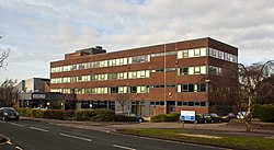
The council is based at the Civic Centre on West Paddock in Leyland. The building was built in the early 1970s for the former Leyland Urban District Council. [18]

Parishes

There are eight civil parishes in the borough. The parish council for Penwortham has declared its parish to be a town, allowing it to take the style "town council". The parishes of Samlesbury and Cuerdale share a grouped parish council. [19] The former urban districts of Leyland and Walton-le-Dale are unparished areas. [9]

The parishes are:

  1. Cuerdale
  2. Farington
  3. Hutton
  4. Little Hoole
  5. Longton
  6. Much Hoole
  7. Penwortham (town)
  8. Samlesbury

South Ribble parishes Borough of South Ribble parishes map.svg
South Ribble parishes

Twin Town

South Ribble is twinned with: [20]

Freedom of the Borough

The following people and military units have received the Freedom of the Borough of South Ribble.

Individuals

Military Units

Footnotes

  1. UK Census (2011). "Local Area Report – South Ribble Local Authority (E07000126)". Nomis. Office for National Statistics . Retrieved 26 March 2021.
  2. "Council minutes, 24 May 2023". South Ribble Borough Council. Retrieved 18 October 2023.
  3. "Councillors". South Ribble Borough Council. Retrieved 4 December 2022.
  4. Aldred, Tim (22 April 2022). "Chorley Council and South Ribble Borough Council appoint shared chief executive". Lancashire Business View. Retrieved 5 October 2023.
  5. "The English Non-metropolitan Districts (Definition) Order 1972", legislation.gov.uk , The National Archives, SI 1972/2039, retrieved 22 August 2022
  6. "The English Non-metropolitan Districts (Names) Order 1973", legislation.gov.uk , The National Archives, SI 1973/551, retrieved 22 August 2022
  7. "District Councils and Boroughs". Parliamentary Debates (Hansard) . 28 March 1974. Retrieved 16 January 2012.
  8. "Local Government Act 1972", legislation.gov.uk , The National Archives, 1972 c. 70, retrieved 31 May 2023
  9. 1 2 3 "Election Maps". Ordnance Survey. Retrieved 17 October 2023.
  10. "Compositions calculator". The Elections Centre. Retrieved 20 August 2022.
  11. "South Ribble". BBC News Online . Retrieved 16 October 2009.
  12. "Council minutes". South Ribble Borough Council. Retrieved 25 August 2022.
  13. Faulkner, Paul (4 June 2021). "'I got into local politics because I'm nosey', confesses outgoing South Ribble Tory leader who ran the borough for a decade". Lancashire Post. Retrieved 25 August 2022.
  14. "Labour takes over scandal-hit South Ribble council". BBC News. 16 October 2018. Retrieved 25 August 2022.
  15. "South Ribble clocks up another leader - and it's a familiar face". Lancashire Post. 1 November 2018. Retrieved 25 August 2022.
  16. "Local elections 2023: live council results for England". The Guardian.
  17. "The South Ribble (Electoral Changes) Order 2014", legislation.gov.uk , The National Archives, SI 2014/3288, retrieved 19 October 2023
  18. "Contact us". South Ribble Borough Council. Retrieved 25 August 2022. Civic Centre, West Paddock, Leyland, Lancashire, PR25 1DH
  19. "Parish council contacts". South Ribble Borough Council. Retrieved 19 October 2023.
  20. South Ribble Borough Council, Town Twinning retrieved 21 January 2019
  21. "Tributes pour in for former South Ribble Mayor and council leader Tony Kelly".
  22. "King's Royal Hussars mark 25 years as honorary freemen with Leyland parade | South Ribble Borough Council". Archived from the original on 26 July 2019. Retrieved 7 March 2021.

53°41′49″N2°41′24″W / 53.697°N 2.690°W / 53.697; -2.690

Related Research Articles

<span class="mw-page-title-main">River Ribble</span> River in North Yorkshire and Lancashire, England

The River Ribble runs through North Yorkshire and Lancashire in Northern England. It starts close to the Ribblehead Viaduct in North Yorkshire, and is one of the few that start in the Yorkshire Dales and flow westwards towards the Irish Sea.

<span class="mw-page-title-main">Amounderness Hundred</span> Subdivision of the historic county of Lancashire

The Amounderness Hundred is one of the six subdivisions of the historic county of Lancashire in North West England, but the name is older than the system of hundreds first recorded in the 13th century and might best be described as the name of a Norse wapentake. In the Domesday Book of 1086, it was used for some territories north of the River Ribble included together with parts of Yorkshire. The area eventually became part of Lancashire, sitting geographically between the Rivers Lune and Ribble, in the strip of coast between the Irish Sea and Bowland Forest.

<span class="mw-page-title-main">Ribble Valley (UK Parliament constituency)</span> Parliamentary constituency in the United Kingdom, 1983 onwards

Ribble Valley is a constituency in Lancashire represented in the House of Commons of the UK Parliament since 1992 by Nigel Evans, a Conservative. Evans has served as a Deputy Speaker of the House of Commons and Second Deputy Chairman of Ways and Means since January 2020; he previously served as First Deputy Chairman of Ways and Means from 2010 to 2013.

<span class="mw-page-title-main">South Ribble (UK Parliament constituency)</span> Parliamentary constituency in the United Kingdom, 1983 onwards

South Ribble is a constituency represented in the House of Commons of the UK Parliament since 2019 by Katherine Fletcher, a Conservative.

<span class="mw-page-title-main">Farington</span> Human settlement in England

Farington is a village and civil parish in the South Ribble local government district of Lancashire, England. The population of the civil parish at the 2011 census was 6,674.

<span class="mw-page-title-main">Lostock Hall</span> Human settlement in England

Lostock Hall is a suburban village within the South Ribble borough of Lancashire, England. It is located on the south side of the River Ribble, some 3 miles (4.8 km) south of Preston and 3 miles (5 km) north of Leyland. It is bordered on its southeastern side by the interchange for the M6, M61 and M65 motorways.

<span class="mw-page-title-main">Bamber Bridge</span> Human settlement in England

Bamber Bridge is a large village in Lancashire, England, 3 miles (5 km) south-east of Preston, in the borough of South Ribble. The name derives from the Old English "bēam" and "brycg", which probably means "tree-trunk bridge". People who live in Bamber Bridge like to be known as Briggers.

<span class="mw-page-title-main">Penwortham</span> Human settlement in England

Penwortham is a town and civil parish in South Ribble, Lancashire, England, on the south bank of the River Ribble facing the city of Preston. The town is at the most westerly crossing point of the river, with major road and rail links crossing it here. The population of the town at the 2011 census was 23,047.

<span class="mw-page-title-main">Central Lancashire</span>

Central Lancashire is an area of Lancashire, England.

<span class="mw-page-title-main">Diocese of Blackburn</span> Diocese of the Church of England

The diocese of Blackburn is diocese of the Church of England in North West England. Its boundaries correspond to northern Lancashire with the exception of the eastern part of the Forest of Bowland, which is part of the diocese of Leeds. The diocese contains 211 parishes and 280 churches. Blackburn Cathedral is the seat of the bishop of Blackburn, currently Philip North, and the diocesan offices are also located in Blackburn.

Preston was a rural district in Lancashire, England from 1894 to 1974. It surrounded Preston to the north, west and east.

<span class="mw-page-title-main">South Ribble Borough Council elections</span> Class of election in the United Kingdom

South Ribble Borough Council elections are held every four years. South Ribble Borough Council is the local authority for the non-metropolitan district of South Ribble in Lancashire, England. Since the last boundary changes in 2015, 50 councillors have been elected from 23 wards. The next borough council elections are due to take place in 2027 as part of the wider 2027 United Kingdom local elections.

<span class="mw-page-title-main">Leyland, Lancashire</span> Town in Lancashire, England

Leyland is a town in South Ribble, Lancashire, England, 6 miles (10 km) south of Preston. The population was 35,578 at the 2011 Census.

<span class="mw-page-title-main">Blue Bus of Penwortham</span>

Blue Bus was a bus operator based in Penwortham, Lancashire. It operated many routes, including services to Preston City Centre.

Chorley Interchange is a bus station in Chorley, England.

<span class="mw-page-title-main">Higher Walton, Lancashire</span> Human settlement in England

Higher Walton is a village in South Ribble, Lancashire, England. It is on the old road between Blackburn and Preston where it crosses the River Darwen. The road, at this point, is now part of the A675. Nearby places include Walton-le-Dale, Coupe Green, and Bamber Bridge.

Hutton is a village and civil parish in Lancashire, England. It is located 3 miles (4.8 km) south west of Preston, in the South Ribble borough and parliamentary constituency. The population of the civil parish at the 2011 census was 2,277.