
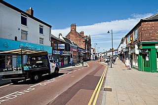
South Ribble is a local government district with borough status in Lancashire, England. Its council is based in Leyland. The borough also includes the towns and villages of Penwortham, Leyland, Farington, Hutton, Longton, Walmer Bridge, Salmesbury, Lostock Hall, Walton le Dale and Bamber Bridge. Many of the built-up areas in the borough form part of the wider Preston built-up area.

Hindley is a town within the Metropolitan Borough of Wigan in Greater Manchester, England. It is three miles (4.8 km) east of Wigan and covers an area of 2,580 acres (1,044 ha). Within the boundaries of the historic county of Lancashire, Hindley borders the towns and villages of Ince-in-Makerfield, Aspull, Westhoughton, Atherton and Westleigh in the former borough of Leigh. In 2001, Hindley had a population of 23,457, increasing to 28,000 at the 2011 Census. It forms part of the wider Greater Manchester Urban Area.
Atherton is a town in the Metropolitan Borough of Wigan in Greater Manchester, England and historically part of Lancashire. The town, including Hindsford, Howe Bridge and Hag Fold, is 5 miles (8.0 km) south of Bolton, 7 miles (11.3 km) east of Wigan, and 10 miles (16.1 km) northwest of Manchester. From the 17th century, for about 300 years, Atherton was known as Chowbent, which was frequently shortened to Bent, the town's old nickname. During the Industrial Revolution, the town was a key part of the Manchester Coalfield.
Euxton is a village and civil parish of the Borough of Chorley, in Lancashire, England. The population of the civil parish as taken at the 2011 census was 9,993, however, the population is now estimated to be around 14,000 due to the increase in housing developments in the village, including the Buckshaw development. The village is situated just to the west of Chorley, and to the south of Clayton-le-Woods.

South Ribble is a constituency represented in the House of Commons of the UK Parliament since 2024 by Paul Foster for Labour.

Longton is a village and civil parish in the west of the borough of South Ribble, Lancashire, England. It is about 4 miles to the south west of Preston. The population of the civil parish, which also includes the village of New Longton, was 5,500 at the 2001 Census increasing to 7,652 at the 2011 Census.

Halton-with-Aughton is a civil parish and electoral ward located 3 miles (5 km) east of Lancaster, England, on the north bank of the River Lune. The main settlement is the village of Halton, or Halton-on-Lune, in the west, and the parish stretches to the hamlet of Aughton in the east. It lies in the City of Lancaster district of Lancashire, and has a population of 2,227, down from 2,360 in 2001.
Tarleton is a village and civil parish in the West Lancashire district of Lancashire, England. It is situated approximately 19 miles (31 km) north-east of Liverpool and 9 miles (14 km) south-west of Preston. The parish includes the village of Mere Brow and the hamlets of Sollom and Holmes, and is an agricultural area. It had a population of 5,959 at the 2021 Census. Tarleton village, Holmes, and the villages of Hesketh Bank and Becconsall to the north form a single built-up area with a population of 8,755.

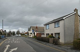
Lostock Hall is a suburban village within the South Ribble borough of Lancashire, England. It is located on the south side of the River Ribble, some 3 miles (4.8 km) south of Preston and 3 miles (5 km) north of Leyland. It is bordered on its southeastern side by the interchange for the M6, M61 and M65 motorways.

Longton is one of the six towns which amalgamated to form the county borough of Stoke-on-Trent in 1910, along with Hanley, Tunstall, Fenton, Burslem and Stoke-upon-Trent in Staffordshire, England.
Croston is a village and civil parish near Chorley in Lancashire, England. The River Yarrow flows through the village. The population of the civil parish taken at the 2011 census was 2,917.

Banks is a large coastal village in the civil parish of North Meols, in the West Lancashire district, in Lancashire, England, south of the Ribble estuary four miles (6 km) north-east of Southport town centre. In 2021 it had a population of 4430. It is in the Southport parliamentary constituency.
Midge Hall is a small village on the outskirts of Leyland in the borough of South Ribble, Lancashire, England.

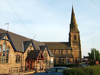
Much Hoole is a village and civil parish in the borough of South Ribble, Lancashire, England. The parish of Much Hoole had a population of 1,851 at the time of the 2001 census, increasing to 1,997 at the 2011 Census.
New Longton and Hutton station was a railway station on the West Lancashire Railway in England. It was over a mile from each of the villages of Hutton and Howick Cross.

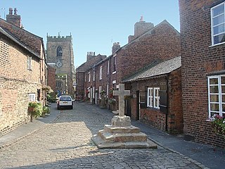
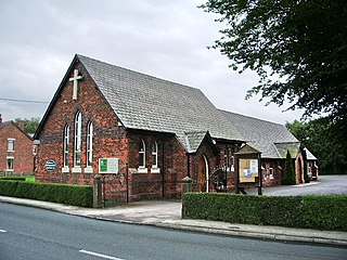
New Longton is a village located 4 miles (6 km) south west of Preston, in the district of South Ribble, in the county of Lancashire, North West England. It is in the parish of Longton, which is the name of the older village located 2 miles (3 km) to the west of New Longton.

Sutton is a village and civil parish near Dover in Kent, England. In 1935 this village became a parish when the small settlements of Studdal, Sutton, Ashley, Little Mongeham and Maydensole joined to become the Parish of Sutton-by-Dover. Prior to this Sutton has had a vast history of agricultural practices, which has helped sustain the village into the parish it is today. The quoted population includes the villages of East and West Studdal plus Swingate and the hamlet of Little Mongeham.
Little Hoole is a civil parish in Lancashire, England, It contains the village of Walmer Bridge, and the remaining part is predominantly a farming community. Other nearby villages include Much Hoole and Longton. The parish had a population of 1,815 people in 2001, increasing to 2,070 at the 2011 Census.

Broomfields is a historic district on the south eastern edge of Bradford, West Yorkshire, England. In 1840 it was still a mainly rural area with a population of only a few hundred people. By 1880 it was one of the most densely populated districts of Bradford with 1,500 houses, a population of about 8,000 and many commercial premises. In 1932 a process of slum clearance and commercial regeneration was started. Today (2014) the district is almost wholly given over to commercial premises and once again has a resident population of only about two hundred people.
Little Hoole is a civil parish in the South Ribble district of Lancashire, England. It contains two listed buildings that are recorded in the National Heritage List for England. Both of the listed buildings are designated at Grade II, the lowest of the three grades, which is applied to "buildings of national importance and special interest". The parish contains the village of Walmer Bridge, and is otherwise rural, The listed buildings comprise a former manor house and a farmhouse, both dating from the 17th century.


