Walton Summit

Last updated

Walton Summit
Walton Summit Road - geograph.org.uk - 1805245.jpg
Location map United Kingdom Borough of South Ribble 2020.svg
Red pog.svg
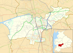
Walton Summit
Shown within South Ribble
Lancashire UK location map.svg
Red pog.svg
Walton Summit
Location within Lancashire
District
Shire county
Region
Country England
Sovereign state United Kingdom
Police Lancashire
Fire Lancashire
Ambulance North West
List of places
UK
England
Lancashire
53°43′24″N2°38′34″W / 53.7234°N 2.6429°W / 53.7234; -2.6429

Walton Summit is an industrial area between Clayton Brook and Bamber Bridge, near Preston in Lancashire, England. It is in the South Ribble district. It is near the M61, M65 and M6 motorways and has a bit of single carriageway motorway from the M65/M61 roundabout. Walton Summit also includes the smaller area of Seed Lee.

Contents

History

The area does not have a long industrial past. As late as 1960, the area remained largely rural despite the then recent construction of the Preston By-pass section of the new M6 motorway. [1] Despite this, the area was important toward the south east near Brindle as the summit of the Lancaster Canal's Walton Summit canal basin. This southerly stretch of canal was linked to the northern section at its Preston basin via the Lancaster Canal Tramroad, locally known as "Old Tram Road". [2]

See also

Related Research Articles

<span class="mw-page-title-main">North West England</span> Region of England

North West England is one of nine official regions of England and consists of the ceremonial counties of Cheshire, Cumbria, Greater Manchester, Lancashire and Merseyside. The North West had a population of 7,417,397 in 2021. It is the third-most-populated region in the United Kingdom, after the South East and Greater London. The largest settlements are Manchester and Liverpool.

<span class="mw-page-title-main">Preston, Lancashire</span> City in Lancashire, England

Preston is a city on the north bank of the River Ribble in Lancashire, England. The city is the administrative centre of the county of Lancashire and the wider City of Preston local government district. Preston and its surrounding district obtained city status in 2002, becoming England's 50th city in the 50th year of Queen Elizabeth II's reign. Preston has a population of 114,300, the City of Preston district 132,000 and the Preston Built-up Area 313,322. The Preston Travel To Work Area, in 2011, had a population of 420,661, compared with 354,000 in the previous census. The south bank of the Ribble is part of the Preston urban area, although it forms the South Ribble borough that is administratively separate.

<span class="mw-page-title-main">Lancaster Canal</span> Canal in Northwest England

The Lancaster Canal is a canal in North West England, originally planned to run from Westhoughton in Lancashire to Kendal in south Cumbria. The section around the crossing of the River Ribble was never completed, and much of the southern end leased to the Leeds and Liverpool Canal, of which it is now generally considered part.

<span class="mw-page-title-main">M6 motorway</span> Longest motorway in England

The M6 motorway is the longest motorway in the United Kingdom. It is located entirely within England, running for just over 230 miles (370 km) from the Midlands to the border with Scotland. It begins at Junction 19 of the M1 and the western end of the A14 at the Catthorpe Interchange, near Rugby before heading north-west. It passes Coventry, Birmingham, Wolverhampton, Stoke-on-Trent, Preston, Lancaster and Carlisle before terminating at Junction 45 near Gretna. Here, just short of the Scottish border it becomes the A74(M) which continues to Glasgow as the M74. Its busiest sections are between junctions 4 and 10a in the West Midlands, and junctions 16 to 19 in Cheshire; these sections have now been converted to smart motorways.

<span class="mw-page-title-main">A6 road (England)</span> North-south road in England

The A6 is one of the main north–south roads in England. It runs from Luton in Bedfordshire to Carlisle in Cumbria, although it formerly started at a junction with the A1 at Barnet in north London, and is described as running from London to Carlisle.

<span class="mw-page-title-main">M65 motorway</span> Motorway in England

The M65 is a motorway between Preston and Colne in Lancashire, England. It runs from Bamber Bridge just south of Preston, through major junctions with the M6 and M61 motorways, east past Darwen, Blackburn, Accrington, Burnley, Brierfield, Nelson and ends at Colne.

<span class="mw-page-title-main">M61 motorway</span> Motorway in North West England

The M61 is a motorway in North West England between Manchester and Preston, linking the M60 Manchester orbital motorway with the M6 motorway.

<span class="mw-page-title-main">M55 motorway</span> Preston–Blackpool motorway in England

The M55 is a motorway in Lancashire, England, which can also be referred to as the Preston Northern Bypass. It connects the seaside resort of Blackpool to the M6 at Preston. It is 12.2 miles (19.6 km) in length.

<span class="mw-page-title-main">M58 motorway</span> Motorway in England

The M58 is a motorway passing through Merseyside and Lancashire, terminating in Greater Manchester. It is 12 miles (19.3 km) long and provides a link between the M6 motorway and the Metropolitan Borough of Sefton and hence on, via the A5036, to the Mersey docks in Liverpool and Birkenhead.

<span class="mw-page-title-main">Orrell, Greater Manchester</span> Human settlement in England

Orrell is a suburb of Wigan in the Metropolitan Borough of Wigan, Greater Manchester, England. The population of the ward had fallen at the 2011 Census to 11,513. The area lies 3 miles (4.8 km) to the west of Wigan town centre. The area is contiguous with Pemberton.

<span class="mw-page-title-main">Lostock Hall</span> Village in Lancashire, England

Lostock Hall is a suburban village within the South Ribble borough of Lancashire, England. It is located on the south side of the River Ribble, some 3 miles (4.8 km) south of Preston and 3 miles (5 km) north of Leyland. It is bordered on its southeastern side by the interchange for the M6, M61 and M65 motorways.

<span class="mw-page-title-main">Clayton-le-Woods</span> Village in Lancashire, England

Clayton-le-Woods is a large village and civil parish of the Borough of Chorley, in Lancashire, England. According to the census of 2001, it has a population of 14,528. At the 2011 census the population of Cuerden civil parish was included within Clayton-le-Woods, giving a total of 14,532.

<span class="mw-page-title-main">Bamber Bridge</span> Settlement in England

Bamber Bridge is a large village in Lancashire, England, 3 miles (5 km) south-east of Preston, in the borough of South Ribble. The name derives from the Old English "bēam" and "brycg", which probably means "tree-trunk bridge". People who live in Bamber Bridge like to be known as Briggers.

<span class="mw-page-title-main">Clayton Brook</span> Human settlement in England

Clayton Brook is a large residential estate in Lancashire, between the city of Preston and the town of Chorley. It forms part of the Clayton-le-Woods civil parish, and is in the Clayton-le-Woods North ward of the borough of Chorley.

<span class="mw-page-title-main">Whittle-le-Woods</span> Village in Lancashire, England

Whittle-le-Woods is a village and civil parish of the Borough of Chorley in Lancashire, England. The population of the civil parish at the 2011 census was 5,434.

<span class="mw-page-title-main">Lancaster Canal Tramroad</span> Former horse-drawn railway in Lancashire, England

The Lancaster Canal Tramroad, also known as the Walton Summit Tramway or the Old Tram Road, was a British plateway, completed in 1803, to link the north and south ends of the Lancaster Canal across the Ribble valley, pending completion of the canal. The canal link was never constructed.

<span class="mw-page-title-main">New Longton</span> Village in Lancashire, England

New Longton is a village located 4 miles (6 km) south west of Preston, in the district of South Ribble, in the county of Lancashire, North West England. It is in the parish of Longton, which is the name of the older village located 2 miles (3 km) to the west of New Longton.

<span class="mw-page-title-main">Northern Reaches Restoration Group</span>

The Northern Reaches Restoration Group is a waterway society in Lancashire and Cumbria, England, UK. The purpose of the NRRG is to campaign for the re-opening of the final 14-mile stretch of the Lancaster Canal between Tewitfield Locks and Kendal. The Northern Reaches, as they are so named, became isolated from the rest of the canal following the construction of the M6 motorway in the 1960s. The navigation authority for the waterway is the Canal & River Trust, formerly British Waterways.

<span class="mw-page-title-main">Transport in Preston</span>

Preston is a city in Lancashire, around 50 kilometres (31 mi) north-west of Manchester.

<span class="mw-page-title-main">Preston By-pass</span> United Kingdoms first motorway

The Preston Bypass was the United Kingdom's first motorway, opened in 1958. It was designed and engineered by Lancashire County Council surveyor James Drake as part of a larger initiative to create a north-south motorway network that would later form part of the M6 motorway. The original 8+14-mile (13.3 km) motorway ran around the east side of Preston between Bamber Bridge and Broughton and crossed over the River Ribble at Samlesbury at the M6 Junction 31.

References

  1. Lancashire Country Council, 'MARIO: Mapping - (1960s overlay)'
  2. H. Potter, The Last Boat to Walton Summit, pp. 96-98 (Lancashire Canal Trust, 2008)