Borough of Warrington

Last updated

Borough of Warrington
Warrington from the Air - geograph.org.uk - 3153500.jpg
Aerial view of Warrington
Motto(s): 
Latin: Deus Dat Incrementum, lit. 'God giveth the increase'
Warrington UK locator map.svg
Warrington shown within Cheshire
England location map.svg
Red pog.svg
Borough of Warrington
Location within England
United Kingdom adm location map.svg
Red pog.svg
Borough of Warrington
Location within the United Kingdom
Europe blank laea location map.svg
Red pog.svg
Borough of Warrington
Location in Europe
Coordinates: 53°23′22″N2°35′27″W / 53.3895°N 2.5909°W / 53.3895; -2.5909 [1]
OS grid reference SJ 6079 8824 [1]
Sovereign state United Kingdom
Country England
Region North West
Ceremonial county Cheshire
Historic counties
Incorporated1 April 1974
Unitary authority1 April 1998
Named for Warrington
Administrative HQ Warrington Town Hall
Government
[2]
  Type Unitary authority with leader and cabinet
  Body Warrington Borough Council
   Control Labour
   Leader Hans Mundry (L)
   Mayor Steve Wright
   Chief Executive Steven Broomhead
   House of Commons
Area
[3]
  Total70.4 sq mi (182.4 km2)
  Land69.7 sq mi (180.6 km2)
  Rank 151st
Population
 (2021) [4]
  Total211,227
  Rank 90th
  Density3,030/sq mi (1,169/km2)
Demonym Warringtonian
Ethnicity (2021)
[5]
   Ethnic groups
List
Religion (2021)
[5]
   Religion
List
Time zone UTC+0 (GMT)
  Summer (DST) UTC+1 (BST)
Postcode areas
WA1–5, WA13
Dialling code 01925
ISO 3166 code GB-WRT
GSS code E06000007
ITL code TLD61
GVA 2021 estimate [6]
 Total £8.5 billion
 Per capita£40,085
GDP (nominal)2021 estimate [6]
 Total£9.3 billion
 Per capita£44,205
Website warrington.gov.uk

The Borough of Warrington is a unitary authority area with borough status in the ceremonial county of Cheshire, England. The borough is centred around the town of Warrington, and extends out into outlying villages of Lymm and Great Sankey and the town of Birchwood.

Contents

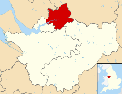
The borough is geographically located to the north and northeast of the Cheshire West and Chester and Halton districts in Cheshire, the metropolitan borough of St Helens in Merseyside to the northwest and north and the metropolitan boroughs of Wigan and Trafford in Greater Manchester to the northeast, east, and southeast. Additionally, to the south-east, the borough borders Cheshire East. The borough is also located between the cities of Liverpool, Salford, Manchester, Chester and Preston. The district straddles the historic counties of Cheshire (the South part of the district includes Lymm and Stockton Heath) and Lancashire (the North part including Warrington itself and Latchford).

Civil parishes

The borough contains the unparished area of Warrington and 18 civil parishes: [7]

History

The borough was historically split between the historic counties of Cheshire and Lancashire. [9] [10] [11]

The whole part of the borough (north of the River Mersey) was within the historic boundaries of the county of Lancashire which includes the town of Warrington, and the areas of Latchford, Great Sankey, Culcheth, Glazebury, Burtonwood and Birchwood.

The whole part of the borough (south of the River Mersey) was within the historic boundaries of the county of Cheshire which includes the villages of Lymm, Stockton Heath, Appleton Thorn and Stretton.

In 1974, local government reforms saw many old counties and districts abolished and new counties and districts were created. Warrington along with the neighboring town of Widnes was moved into the county of Cheshire (which saw the entire area from the border with Speke/Widnes to Glazebury/Cadishead moved into the county of Cheshire). The current borough was formed from the County Borough of Warrington, the wards of Culcheth and Newchurch in Golborne Urban District, Warrington Rural District and part of the parish of Bold in Whiston Rural District, in Lancashire and Lymm Urban District and the parishes of Appleton, Grappenhall, Hatton, Stockton Heath, Stretton and Walton from Runcorn Rural District in Cheshire. [12] The M62 motorway forms a border with both Greater Manchester and Merseyside. [13]

The borough became a unitary authority in 1998 alongside Halton [14] making it separate from the-then Cheshire County Council before the 2009 restructuring of local government which saw the county council abolished and replaced by two new unitary authorities, Cheshire East and Cheshire West (and Chester). All four unitary authorities still form Cheshire for ceremonial purposes and share local services. [15] [16]

Related Research Articles

Latchford is a suburb and electoral ward of Warrington, Cheshire, England. It is around one mile south-east of Warrington town centre and has a total resident population of 7,856.

<span class="mw-page-title-main">Woolston, Cheshire</span> Human settlement in England

Woolston is a settlement and civil parish in the Borough of Warrington in the county of Cheshire, England. Formerly a township called 'Woolston with Martinscroft' within the parish of Warrington, there are two main settlements: Woolston to the west and Martinscroft to the east. Formerly within the historic county of Lancashire, the parish is on the north bank of the River Mersey and takes in Paddington to the south-west. It is bounded by the River Mersey to the south, Bruche and Padgate to the west, Longbarn and Birchwood to the north and Rixton to the east.

<span class="mw-page-title-main">Warrington South (UK Parliament constituency)</span> Parliamentary constituency in the United Kingdom, 1983 onwards

Warrington South is a constituency represented in the House of Commons of the UK Parliament since 2019 by Andy Carter, a Conservative Party politician.

<span class="mw-page-title-main">Warrington Borough Council</span>

Warrington Borough Council is the local authority of Warrington, Cheshire, England. It is a unitary authority, having the powers of a non-metropolitan county and district council combined. It provides a full range of local government services including Council Tax billing, libraries, social services, processing planning applications, waste collection and disposal, and it is a local education authority.

<span class="mw-page-title-main">Warrington North (UK Parliament constituency)</span> Parliamentary constituency in the United Kingdom, 1983 onwards

Warrington North is a parliamentary constituency represented in the House of Commons of the Parliament of the United Kingdom since 2019 by Charlotte Nichols of the Labour Party. It elects one Member of Parliament (MP) by the first past the post system of election.

<span class="mw-page-title-main">Culcheth</span> Village near Warrington, England

Culcheth is a village in the civil parish of Culcheth and Glazebury, Cheshire, England, six miles (10 km) north-east of Warrington.

Priestley Sixth Form and Community College is a sixth form college in Warrington, Cheshire, England. It also offers adult courses and professional training on another site, and is an associate college of the University of Salford. The college offers a range of courses, including AS/A2 Levels, BTECs, Advanced Diplomas, functional skills, and pre-university foundation courses.

<span class="mw-page-title-main">Runcorn Rural District</span> Rural district in Cheshire, England

Runcorn was a rural district in Cheshire, England from 1894 until 1974. It was named after but did not include Runcorn, a town on the River Mersey to the north-west of the district, which formed its own urban district.

There are various modes of transport available in Warrington.

<span class="mw-page-title-main">Warrington Corporation Tramways</span>

Warrington Corporation Tramways was the owner and operator of an electric tramway system in the early 20th century serving the town of Warrington, at the time a county borough of Lancashire, England.

<span class="mw-page-title-main">Warrington</span> Town in Cheshire, England

Warrington is an industrial town in the borough of the same name in Cheshire, England. The town sits on the banks of the River Mersey and is historically part of Lancashire. It is 19 miles (31 km) east of Liverpool, and 18 miles (29 km) west of Manchester.

The county of Cheshire, England, has many buildings that have been listed.

There are over 9,000 Grade I listed buildings and 20,000 Grade II* listed buildings in England. This page is a list of these buildings in the unitary authority of Warrington in Cheshire, including the town of Warrington and 18 other civil parishes.

The Warrington & District Football League was originally formed in 1895 and was reformed in 1919. It is one of the oldest football leagues in England and in 2013 the league become a F.A. Charter Standard League.

The ceremonial county of Cheshire, which comprises the unitary authorities of Cheshire East, Cheshire West and Chester, Halton and Warrington, has returned 11 MPs to the UK Parliament since 1997.

References

  1. 1 2 "Warrington, North West". Ordnance Survey . Retrieved 16 January 2024.
  2. "Democracy, elections and civic". Warrington Borough Council. Retrieved 18 December 2023.
  3. "Mid-Year Population Estimates, UK, June 2021". Office for National Statistics. 21 December 2022. Retrieved 18 October 2023.
  4. "Mid-Year Population Estimates, UK, June 2021". Office for National Statistics. 21 December 2022. Retrieved 18 October 2023.
  5. 1 2 UK Census (2021). "2021 Census Area Profile – Warrington Local Authority (E06000007)". Nomis. Office for National Statistics . Retrieved 18 December 2023.
  6. 1 2 Fenton, Trevor (25 April 2023). "Regional gross domestic product: local authorities". Office for National Statistics. Retrieved 13 December 2023.
  7. "Warrington". Ordnance Survey . Retrieved 2 June 2022.
  8. "Birchwood Town Council | Warrington | Cheshire". www.birchwoodtowncouncil.org.uk. Retrieved 30 May 2022.
  9. "Council rules out new signs to show town 'located' in Lancashire". Warrington Guardian. Retrieved 30 May 2022.
  10. "Old Maps of Warrington history". www.alangodfreymaps.co.uk. Retrieved 30 May 2022.
  11. "History of Warrington in Lancashire". A Vision of Britain Through Time. Retrieved 30 May 2022.
  12. "The English Non-metropolitan Districts (Definition) Order 1972". legislation.gov.uk . Retrieved 2 June 2022.
  13. "Genuki: Warrington Parish Boundaries, Lancashire". www.genuki.org.uk. Retrieved 31 May 2022.
  14. "The Cheshire (Boroughs of Halton and Warrington) (Structural Change) Order 1996". legislation.gov.uk . Retrieved 2 June 2022.
  15. Fire, Cheshire. "Unitary Performance Area Profiles". Cheshire Fire and Rescue Service. Retrieved 31 May 2022.
  16. Norbury, David (13 October 2018). "Have Cheshire's Unitary Authorities worked?". CheshireLive. Retrieved 31 May 2022.