
Salford is a city in Greater Manchester, England. The city is situated in a meander on the western bank of the River Irwell which forms its boundary with Manchester and its city centre. Landmarks in the city include the old town hall, cathedral and St Philips Church. It is the main settlement of the wider City of Salford metropolitan borough.

The Manchester Ship Canal is a 36 mi-long (58 km) inland waterway in the North West of England linking Manchester to the Irish Sea. Starting at the Mersey Estuary at Eastham, near Ellesmere Port, Cheshire, it generally follows the original routes of the rivers Mersey and Irwell through the historic counties of Cheshire and Lancashire. Several sets of locks lift vessels about 60 ft (18 m) to the canal's terminus in Manchester. Landmarks along its route include the Barton Swing Aqueduct, the world's only swing aqueduct, and Trafford Park, the world's first planned industrial estate and still the largest in Europe.

Irlam is a suburb in the City of Salford, Greater Manchester, England. In 2011, it had a population of 19,933. It lies on flat ground on the south side of the M62 motorway and the north bank of the Manchester Ship Canal, 6.7 miles (10.8 km) southwest of Salford, 7.6 miles (12.2 km) southwest of Manchester and 8.3 miles (13.4 km) northeast of Warrington. Irlam forms a continuous urban area with Cadishead to the southwest, and is divided from Flixton and the Metropolitan Borough of Trafford to the southeast by the Manchester Ship Canal. The main road through Irlam, linking it to Cadishead and Eccles, is the A57. Irlam railway station also serves the district.

Salford, also known as the City of Salford, is a metropolitan borough with city status in Greater Manchester, England. The borough is named after its main settlement, Salford, but covers a larger area which includes the towns of Eccles, Swinton, Walkden and Pendlebury. The borough had a population of 278,064 in 2022, and is administered from the Salford Civic Centre in Swinton.

Worsley is a village in the City of Salford, Greater Manchester, England, which in 2014 had a population of 10,090. It lies along Worsley Brook, 6 miles (9.7 km) west of Manchester.

Boothstown is a suburban village in the City of Salford in Greater Manchester, England. Boothstown forms part of the Boothstown and Ellenbrook ward, which had a population at the 2011 Census of 9,599. The village is within the boundaries of the historic county of Lancashire, west of the City of Salford, bordered to the north by the East Lancashire Road A580 and to the south by the Bridgewater Canal. Historically, it was a hamlet partly in Worsley township in the parish of Eccles, and partly in Tyldesley in the parish of Leigh.

Pendlebury is a town in the City of Salford, Greater Manchester, England. The population at the 2011 Census was 13,069. It lies 4 miles (6 km) north-west of Manchester, 3 miles (5 km) north-west of Salford and 6 miles (10 km) south-east of Bolton.

Eccles is a market town in the City of Salford in Greater Manchester, England, 3 miles (4.8 km) west of Salford and 4 miles (6.4 km) west of Manchester, split by the M602 motorway and bordered by the Manchester Ship Canal to the south. The town is famous for the Eccles cake.
Worsley was a parliamentary constituency represented in the House of Commons of the Parliament of the United Kingdom. It elected one Member of Parliament (MP) by the first past the post system of election.

Partington is a town and civil parish in the Metropolitan Borough of Trafford, Greater Manchester, England, ten miles (16 km) south-west of Manchester city centre. Within the boundaries of the historic county of Cheshire, it lies on the southern bank of the Manchester Ship Canal, opposite Cadishead on the northern bank. It has a population of 7,327.

Barton upon Irwell is a suburb of the City of Salford, Greater Manchester, England, with a population of 12,462 in 2014.
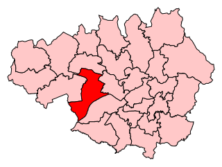
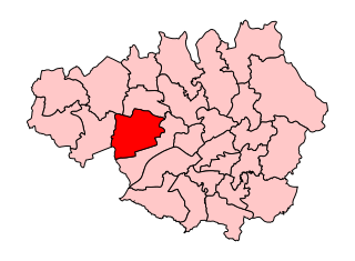
Worsley and Eccles South is a county constituency represented in the House of Commons of the Parliament of the United Kingdom. The seat is currently held by Barbara Keeley MP of the Labour Party. It elects one Member of Parliament (MP) by the first past the post system of election.
Seedley is an inner city suburb of Salford, Greater Manchester, England.
Winton is an area of the City of Salford in Greater Manchester, England, which in 2014 had a population of 12,339.

Little Hulton is an area in the City of Salford, Greater Manchester, England, 3.4 miles (5.5 km) south of Bolton, 7 miles (11.3 km) northwest of Salford, and 9 miles (14.5 km) northwest of Manchester. Within the boundaries of the historic county of Lancashire, Little Hulton is bordered by Farnworth to the north, Walkden to the east and Tyldesley to the south.

Ellenbrook is a suburb of Worsley, in the City of Salford in Greater Manchester, England. Ellenbrook is 6.8 miles (10.9 km) west of Manchester, 5 miles (8.0 km) west of Salford and 4.6 miles (7.4 km) south of Bolton. Historically a part of Lancashire, it is close to Astley, Mosley Common and Walkden, by the East Lancashire Road.
Cadishead railway station was a railway station on the Cheshire Lines Committees Glazebrook East Junction to Skelton Junction Line serving the village of Cadishead, near Irlam, Greater Manchester.

Walkden South is an area and electoral ward of Salford, England. It is represented in Westminster by Barbara Keeley MP for Worsley and Eccles South. A profile of the ward conducted by Salford City Council in 2014 recorded a population of 10,185.

Irlam was an electoral ward of Salford, England. It was represented in Westminster by the constituency of Worsley and Eccles South. A profile of the ward conducted by Salford City Council in 2014 recorded a population of 9,857.

Little Hulton is an electoral ward of Salford, England. It is represented in Westminster by Barbara Keeley MP for Worsley and Eccles South. A profile of the ward conducted by Salford City Council in 2014 recorded a population of 13,469.


