Scheduled monuments in Greater Manchester

Last updated

Smithills Hall is one of several medieval manor houses in Greater Manchester to be protected as a scheduled monument Smithills Hall in 2004.jpg
Smithills Hall is one of several medieval manor houses in Greater Manchester to be protected as a scheduled monument

There are 37 scheduled monuments in Greater Manchester, a metropolitan county in North West England. In the United Kingdom, a scheduled monument is a "nationally important" archaeological site or historic building that has been given protection against unauthorised change by being placed on a list (or "schedule") by the Secretary of State for Culture, Media and Sport, following advice from Historic England. [1] Scheduled monuments are defined in the Ancient Monuments and Archaeological Areas Act 1979 and the National Heritage Act 1983. There are nearly 20,000 entries on the schedule, which is maintained by Historic England as part of the National Heritage List for England; more than one site can be included in a single entry. While a scheduled monument can also be recognised as a listed building, Historic England's aim is to ensure that the most appropriate form of protection is applied to the building or site. [2] Applications to deschedule a site are administered by Historic England, which carries out an assessment and makes a recommendation to the Secretary of State. [2]

Contents

The metropolitan county of Greater Manchester is composed of ten metropolitan boroughs: Bolton, Bury, Manchester, Oldham, Rochdale, Salford, Stockport, Tameside, Trafford and Wigan. The scheduled monuments in each borough are listed separately. They range from prehistoric structures—the oldest of which date from the Bronze Age—to more modern structures such as Astley Green Colliery, which dates from 1908. [3] Greater Manchester has seven prehistoric monuments (i.e. Bronze or Iron Age), found in Bury, Oldham, Salford, Stockport, and Tameside. The Bronze Age sites are mainly cairns and barrows, and both the Iron Age sites are military in nature, being promontory forts.

The trend of military sites continues from the Iron Age into the Roman period; two Roman forts in Greater Manchester are scheduled monuments and were the two main areas of Roman activity in the county. Of the nine castles in Greater Manchester, four are scheduled monuments: Buckton Castle, [4] Watch Hill Castle, [5] Bury Castle, [6] and Radcliffe Tower. [7] The last two are fortified manor houses, and although defined as castles, they were not exclusively military in nature; they probably acted as the administrative centre of the manors they served. [8] There are several other manor houses and country houses—some with moats—in the county that are protected as scheduled monuments. Astley Green Colliery, Marple Aqueduct, [9] Oldknow's Limekilns, [10] and Worsley Delph [11] are scheduled relics of Greater Manchester's industrial history.

Bolton

NameRemainsDateLocationDescriptionRef(s) [A]
Round cairn
(nr. Old Harper's Farm)
Cairn Bronze Age Horwich 53°36′25″N2°30′39″W / 53.6070°N 2.5107°W / 53.6070; -2.5107 (Round cairn on Winter Hill) On the eastern slope of Adam Hill, in the Winter Hill massif, a round cairn on a local high point 280 metres (920 ft) west of Old Harpers Farm. It is a slightly oval mound of stones, covered with turf, measuring approximately 12 m (39 ft) by 11.5 m (38 ft) and standing 0.4 m (1 ft 4 in) high. The cairn is unexcavated and retains undisturbed deposits of archaeological value. [12]
Stone circle, ring cairn and two round cairns CairnsBronze Age Egerton 53°38′20″N2°25′49″W / 53.6388°N 2.4303°W / 53.6388; -2.4303 A prehistoric complex comprising a damaged stone circle, a ring cairn, and two round cairns. The site lies on a high ridge above Bromley Cross, close to the boundary with Lancashire, and preserves significant archaeological remains despite historic disturbance. [13]
Moated site at Arley HallMoat13th–14th century Blackrod 53°35′27″N2°37′17″W / 53.5909°N 2.6214°W / 53.5909; -2.6214 (Arley Hall) A well‑preserved medieval moated site consisting of a near‑circular, water‑filled moat enclosing a central platform occupied by a later house. The moat survives to substantial width with stone‑revetted banks, and access is provided by a 19th‑century iron bridge. [14]
Smithills Hall Standing building14th century Bolton 53°36′08″N2°27′15″W / 53.6023°N 2.4542°W / 53.6023; -2.4542 (Smithills Hall) Originally built in the early 14th century, but was extended in the 15th and 16th centuries. The oldest surviving part is the great hall, which dates from the early 15th century. The site was originally moated; however, no trace of the moat survives. Smithills Hall is now a Grade I listed building and is open to the public as a museum. [15] [16]
Ringley Old Bridge Stone bridge1677 Stoneclough, Kearsley 53°32′37″N2°21′26″W / 53.5437°N 2.3573°W / 53.5437; -2.3573 (Ringley Old Bridge) 
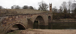
The current bridge over the River Irwell was built in 1677 to replace one that was washed away in 1673. It is still in use today, having been pedestrianised, and is a Grade II* listed building. [17] [18] [19]
Chequerbent embankmentRailway embankmentc.1828 Westhoughton 53°33′02″N2°29′40″W / 53.5505°N 2.4944°W / 53.5505; -2.4944 (Chequerbent) 
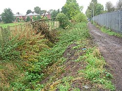
A surviving section of the Bolton and Leigh Railway, located between the A6 Manchester Road and the M61 motorway, approximately 200 m (660 ft) east of the A58, and preserved as an earth embankment with a raised stone‑built track bed. [20]

Bury

NameRemainsDateLocationDescriptionRef(s) [A]
Castlesteads Earthworks200 BC250 AD Bury 53°36′46″N2°18′25″W / 53.6129°N 2.3070°W / 53.6129; -2.3070 (Castlesteads) A promontory fort on the banks of the River Irwell. The site is defended by a ditch 120 m (390 ft) long and 6 m (20 ft) wide, along with a silted-up channel of the river. The interior is triangular in shape. Pottery finds indicate the site was occupied from 200 BC to 250 AD. [21] [22]
Radcliffe Tower Ruins1403 Radcliffe 53°33′49″N2°18′30″W / 53.5636°N 2.3083°W / 53.5636; -2.3083 (Radcliffe Tower) The only surviving part of a medieval manor house that belonged to James de Radliffe, the Lord of the Manor of Radcliffe. The house was a stone-built hall with two towers and was surrounded by a moat. The site was fortified with crenellations and battlements, added with permission from the king. The manor house was demolished in the 19th century, and the tower is now a Grade I listed building. [7] [23] [24]
Bury Castle Below ground remains1469 Bury 53°35′37″N2°17′49″W / 53.5937°N 2.2970°W / 53.5937; -2.2970 (Bury Castle) 
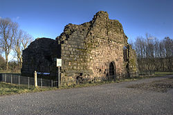
A manor house built in 1469, replacing an earlier building on the same site dating from the late 14th century. It was constructed by Sir Thomas Pilkington, Lord of the Manors of Bury and Pilkington, and fortified with the king's permission; it was later razed to the ground when Sir Thomas had his lands confiscated for supporting the losing side in the War of the Roses. Some of the castle remains have been excavated and are now on display to the public. [6]
Affetside Cross Stone pillar17th or 18th century Affetside 53°37′08″N2°22′16″W / 53.6190°N 2.3710°W / 53.6190; -2.3710 (Affetside Cross) The pillar was originally a cross and replaced a medieval waymarker in the 17th or 18th century. It stands on three circular steps, which probably date from 1890, when the cross was taken down for repairs and re-erected. [25] [26]

Manchester

NameRemainsDateLocationDescriptionRef(s) [A]
Mamucium Below ground remains79 Castlefield 53°28′29″N2°15′12″W / 53.4747°N 2.2532°W / 53.4747; -2.2532 (Mamucium) A Roman fort was established on a sandstone bluff near a crossing of the River Medlock, along the line of the Roman road between Chester (Deva Victrix) and York (Eboracum). It was designed to garrison a cohort of 500  auxiliary soldiers, and a civilian settlement ( vicus ) of traders and families developed around it. Around 140, the fort was demolished and the settlement was abandoned at roughly the same time. The fort was rebuilt in 160 and the settlement re-inhabited. It was abandoned by the mid-3rd century, although the fort remained in use into the early 4th century. A partial reconstruction of the fort on the site is open to the public. [27] [28] [29] [30]
Nico Ditch [B] Earthwork7th9th centuries Ashton-under-Lyne and Denton 53°27′11″N2°24′00″W / 53.4531°N 2.3999°W / 53.4531; -2.3999 (Nico Ditch) An earthwork stretching from Ashton Moss in the east to Hough Moss in the west. According to legend, it was dug in a single night as a defence against Viking invaders in 869–870. However, its U-shaped profile suggests it was not defensive, as a true defensive ditch would more likely be V-shaped. It was probably used as an administrative boundary. The ditch is visible in sections and, in places, is about 1.5 m (4.9 ft) deep and up to 4 m (13 ft) wide. [31] [32] [33]
Baguley Hall Standing building14th century Baguley 53°23′42″N2°16′35″W / 53.3950°N 2.2764°W / 53.3950; -2.2764 (Baguley Hall) 
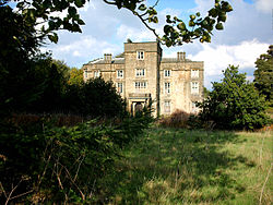
The original building may date from the 11th or 12th century, but the current timber-framed house is from the 14th century. The medieval north wing was refaced in brick, and the brick south wing was added in the 18th century. It is considered one of the "finest surviving medieval halls in the northwest of England". It is a Grade I listed building, and is on the Buildings at Risk Register ; its condition is rated as "poor" and it is owned by Heritage Trust for the North West. [34] [35] [36] [37]
Peel Hall Waterlogged moat14th centuryAshton New Road, Manchester 53°22′41″N2°14′39″W / 53.3780°N 2.2443°W / 53.3780; -2.2443 (Peel Hall) In the mid-14th century, Sir John de Arderne built Peel Hall. The site is surrounded by a moat between 8 and 14 m (26 and 46 ft) wide and 1.2 m (3.9 ft) deep. Peel Hall was demolished in 1809 and replaced by a farmhouse on the same site, which was itself demolished in 1975. [38] [39]
Hanging Bridge Ruins1421Cateaton Street, Manchester 53°29′04″N2°14′36″W / 53.4845°N 2.2433°W / 53.4845; -2.2433 (Hanging Bridge) The current structure was built in 1421; however, the first reference to the bridge dates from 1343. The bridge, which is 33 m (108 ft) long and 2.7 m (8.9 ft) wide, spanned Hanging Ditch and formed part of medieval Manchester's defences. Hanging Bridge was probably obscured by housing in the 1770s as a result of Manchester's expansion. It was uncovered in the 1880s, and again in the late 20th century, and is now on display in Manchester Cathedral's visitor centre. [40] [41] [42] [43]
Clayton Hall Standing building15th century Clayton 53°29′00″N2°10′43″W / 53.4834°N 2.1787°W / 53.4834; -2.1787 (Clayton Hall) The hall, which probably dates back to the 15th century, was originally either a quadrangle or a three-winged structure. Much of it was demolished in the 17th century and replaced by a new house. Clayton Hall underwent further alterations and restoration in the 18th century and again in 1900. It stands on a rectangular island surrounded by a moat and is a Grade II* listed building. [44] [45] [46]

Oldham

NameRemainsDateLocationDescriptionRef(s) [A]
Saddleworth Bowl Barrow Earthworks Bronze Age Saddleworth 53°33′49″N2°01′48″W / 53.5636°N 2.0300°W / 53.5636; -2.0300 (Saddleworth Bowl Barrow) The barrow is oval-shaped and measures 17 m (56 ft) by 18 m (59 ft), with a height of 0.5 m (1.6 ft). It has been archaeologically excavated, but no grave goods or human remains were found. The site is in good condition. [47] [48]
Castleshaw Roman fort Below ground remains79 Castleshaw, Saddleworth 53°35′00″N2°00′06″W / 53.5832°N 2.0017°W / 53.5832; -2.0017 (Castleshaw Roman fort) In 79, a Roman fort was established at Castleshaw to house a garrison of 500 auxiliary soldiers, forming part of the frontier defences along the road between Chester (Deva Victrix) and York (Eboracum). It was slighted in 90, but a smaller fort—or fortlet—was built on the site in 105, designed for a garrison of fewer than 100. A civilian settlement (vicus), made up of traders and hangers-on associated with the soldiers, developed around the fort in the 2nd century. The fortlet was abandoned in the mid-120s when it was superseded by the neighbouring forts at Manchester and Slack. About the same time, the civilian settlement was also abandoned. A series of ditches and earthworks was constructed to mark the site. [49] [50] [51] [52] [53] [54]

Rochdale

NameRemainsDateLocationDescriptionRef(s) [A]
Blackstone Edge Roman road Paved causewayUncertain Littleborough 53°38′57″N2°03′02″W / 53.6491°N 2.0506°W / 53.6491; -2.0506 (Blackstone Edge Roman road) The so‑called Roman road is a paved causeway running between Littleborough and Ripponden. Although long identified as Roman, its date is uncertain: Calderdale archives note that "doubt remains as to whether it is old enough to be Roman." According to the Roman Roads Research Association (RRRA), a medieval packhorse track passes beneath part of the structure, indicating that the paved surface is later in date. The RRRA concludes that the causeway is "almost certainly" an early turnpike, probably constructed in 1735, rather than a Roman road. [55] [56] [57]
March Barn BridgeBridgec.1800 Castleton 53°35′45″N2°10′22″W / 53.5958°N 2.1729°W / 53.5958; -2.1729 (March Barn Bridge) An early 19th‑century skew bridge on the Rochdale Canal, notable as one of the first properly constructed skew bridges in England. Built during the canal's original construction, it carries a roadway over the canal using coursed stone set in a helical pattern. [58] [59]

Salford

NameRemainsDateLocationDescriptionRef(s) [A]
Iron Age promontory fortBelow ground remains500BC200AD Salford 53°26′15″N2°27′54″W / 53.4376°N 2.4651°W / 53.4376; -2.4651 (Salford Iron Age fort) The promontory fort is enclosed by two ditches. Within the interior are four circular structures that were probably used as industrial areas and livestock enclosures. The Cheshire Very Coarse Pottery (VCP) found on the site provides the only evidence of a late prehistoric pottery industry in Greater Manchester. [60] [61]
Wardley Hall moated siteMoatLate 13th century Worsley 53°30′55″N2°22′02″W / 53.5154°N 2.3671°W / 53.5154; -2.3671 (Wardley Hall moated site) The moat, recorded as early as 1292, forms a roughly rectangular island on which the later manor house was constructed. The water‑filled moat survives on all sides and is considered to be of medieval origin, representing a high‑status domestic site typical of the period. The island is thought to have contained earlier timber buildings predating the present hall, which is largely of 16th and 17th‑century date. [62]
Worsley Delph Brick structure1759 Swinton 53°30′03″N2°22′45″W / 53.5008°N 2.3792°W / 53.5008; -2.3792 (Worsley Delph) In 1759 construction began on a system of underground canals that provided a route between Worsley Colliery and the Bridgewater Canal for transporting the coal produced there. The canals remained in use for this purpose until 1887 and were closed shortly after the last coal pit in the area shut in 1968. [11] [63]
Barton Aqueduct embankment and retaining wallsWalls1760–61 Barton upon Irwell 53°28′31″N2°21′12″W / 53.4753°N 2.3534°W / 53.4753; -2.3534 (Barton Aqueduct embankment and retaining walls) The surviving embanked section of James Brindley's aqueduct, together with its associated retaining walls. This includes the later strengthening work which enlarged the embankment between 1822 and 1824, as well as the section of the original canal that was infilled in 1894 when the canal was realigned eastwards as part of the construction of the Manchester Ship Canal. The embankment formed the approach to the stone aqueduct that once carried the Bridgewater Canal over the River Irwell and represents one of the earliest major engineering works of the canal age. [64]
Lime kiln and associated culvertBelow ground remainsc.1770 Worsley 53°29′52″N2°22′40″W / 53.4978°N 2.3779°W / 53.4978; -2.3779 (Wardley Hall moated site) A disused twin‑pot lime kiln and an associated culvert over Worsley Brook. The remains survive as an earth mound containing buried structural elements, including brick and stone tunnels and standing brick and stone walls. [65]

Stockport

NameRemainsDateLocationDescriptionRef(s) [A]
Brown Low Earthworks Bronze Age Ludworth, Hazel Grove 53°24′54″N2°01′04″W / 53.4149°N 2.0177°W / 53.4149; -2.0177 (Brown Low) A bowl barrow measuring 25.5 m (84 ft) in diameter and 2 m (6.6 ft) in height. The mound is grass-covered, and two visible hollows on its surface mark the site of an excavation carried out in 1809. [66] [67]
CairnMound of stones Bronze Age Ludworth, Hazel Grove 53°22′55″N2°01′13″W / 53.3819°N 2.0202°W / 53.3819; -2.0202 (Ludworth cairn) The late Bronze Age cairn measures 12 m (39 ft) in diameter and 0.4 m (1.3 ft) in height. It contains a series of chambers and cremation cists. Positioned on a knoll on Mellor Moor, the cairn is prominently sited and highly visible in the surrounding landscape. [68] [69]
Peel MoatDry moatMedieval Heaton Moor 53°25′43″N2°11′18″W / 53.4287°N 2.1884°W / 53.4287; -2.1884 (Peel Moat) The dried-up rectangular moat surrounds the site of a square-shaped fortified tower. There are no above-ground remains of the tower, but it stood on a plot of land measuring 29 m (95 ft) square, with the moat around it ranging from 5.5 m (18 ft) to 10 m (33 ft) in width. [70] [71]
Torkington MoatWater-logged moatMedieval Torkington 53°23′06″N2°05′28″W / 53.3849°N 2.0910°W / 53.3849; -2.0910 (Torkington Moat) The moat surrounds the site of the manor house first built in 1350. It is 1.6 m (5.2 ft) deep, between 8 and 20 m (26 and 66 ft) wide, and encloses an island measuring 46 m (151 ft) by 43 m (141 ft). Torkington Hall replaced the medieval manor house in the early 17th century. [72] [73]
Oldknow's LimekilnsLime kilns1797 Marple 53°23′34″N2°03′21″W / 53.3927°N 2.0557°W / 53.3927; -2.0557 (Oldknow Limekilns) Between 1797 and 1800, Samuel Oldknow built three lime kilns on the east side of the Peak Forest Canal. The kilns are 11 m (36 ft) deep and were constructed into the hillside. The site remained in use into the 20th century, and the surviving kiln walling is now protected as a Grade II listed building. [10] [74] [75]
Marple Aqueduct Aqueduct 1801 Marple 53°24′25″N2°04′02″W / 53.4070°N 2.0673°W / 53.4070; -2.0673 (Marple Aqueduct) The aqueduct was built between 1794 and 1801 to carry the Peak Forest Canal over the River Goyt. It remains in use today, carrying pleasure craft along the canal and forming one of the most prominent engineering features of the route. [9] [76]

Tameside

NameRemainsDateLocationDescriptionRef(s) [A]
CairnMound of stones Bronze Age Stalybridge 53°28′44″N2°01′06″W / 53.4788°N 2.0184°W / 53.4788; -2.0184 (Stalybridge Cairn) The turf covered round cairn is situated on top of a hill, and consists of a mound of stones with a flat top. It is 1 m (3.3 ft) tall and 16 m (52 ft) in diameter, although the southern edge has been destroyed. The site has been altered in modern period by the addition of a dry stone wall and a trigonometrical pillar. [77] [78]
Nico Ditch [B] Earthwork5th11th centuries Denton 53°27′40″N2°08′43″W / 53.4611°N 2.1454°W / 53.4611; -2.1454 (Nico Ditch) A surviving section of the early medieval ditch, a linear earthwork running east–west across Greater Manchester. At this point on Denton Golf Course, the ditch survives as a well‑preserved earthwork defined by a shallow linear depression representing part of a boundary feature dug between the 5th and 11th centuries. This section is protected for its archaeological value as one of the few intact stretches of the ditch, which elsewhere has been largely levelled by later development. [79]
Buckton Castle Below ground remains1180s Carrbrook 53°30′40″N2°00′58″W / 53.5111°N 2.0162°W / 53.5111; -2.0162 (Buckton Castle) An enclosure castle, probably built by the earls of Chester in the 12th century. It may have been constructed to guard the Longdendale Valley. The castle was first recorded in 1360, when it was already in a ruinous state. It is circular in form, measuring 35 m (115 ft) and 45 m (148 ft) along its axes, and is surrounded by a ditch 10 m (33 ft) wide and 6 m (20 ft) deep. The castle has been damaged by 18th-century treasure hunters and by quarrying in the 19th and 20th centuries. [4] [80] [81] [82] [83]
Post-medieval glassworksBelow ground remains1612 Denton 53°26′55″N2°05′23″W / 53.4485°N 2.0896°W / 53.4485; -2.0896 (Post-medieval glassworks) A post‑medieval glassworks located 250 m (820 ft) south‑east of Clarke's Bridge, consisting of the remains of furnace bases and other structures associated with glass production. The site preserves evidence of small‑scale industrial activity and the layout of a rural glassmaking operation. [84]

Trafford

NameRemainsDateLocationDescriptionRef(s) [A]
Watch Hill Castle Earthworks12th century (probably) Bowdon 53°22′12″N2°22′44″W / 53.3699°N 2.3789°W / 53.3699; -2.3789 (Watch Hill Castle) The castle is a motte-and-bailey, consisting of a conical mound (motte) 40 m (130 ft) in diameter and 17 m (56 ft) high, surrounded by a triangular lower enclosure (bailey) covering 2,400 square metres (0.59 acres). It was probably built for Hamon de Massey, a baron who held several local manors, including Baguley, Bowdon, Dunham, and Hale. The site had fallen out of use by the 13th century. [5] [85] [86]

Wigan

NameRemainsDateLocationDescriptionRef(s) [A]
Cross baseCross baseMedievalJunction of Green Lane, Standish Wood Lane and Beech Walk, Standish 53°34′49″N2°39′43″W / 53.5803°N 2.6620°W / 53.5803; -2.6620 (Cross base) The stone cross was one of four known crosses that marked the medieval route from Wigan to Chorley. The cross base is no longer in its original place, having been moved when the road was widened. [87]
Cross baseCross baseMedievalGreen Lane, Standish 53°34′52″N2°39′38″W / 53.5811°N 2.6605°W / 53.5811; -2.6605 (Cross base) The stone cross was one of four known crosses that marked the medieval route from Wigan to Chorley. It is protected as a Grade II listed building. [88] [89]
Cross baseCross baseMedievalStandish Wood Lane, Standish 53°34′25″N2°39′38″W / 53.5735°N 2.6605°W / 53.5735; -2.6605 (Cross base) The stone cross was one of four known crosses that marked the medieval route from Wigan to Chorley. [90]
Morleys Hall Standing buildingMedieval Astley 53°29′20″N2°28′04″W / 53.4890°N 2.4678°W / 53.4890; -2.4678 (Morleys Hall) The current hall was built in the 19th century, however some 16th and 17th-century timber framing is incorporated into the structure. In 1641 it was the home of Ambrose Barlow. The site is surrounded by a 12–15 m (39–49 ft) wide and 3 m (9.8 ft) deep waterlogged medieval moat, and Morleys Hall is a Grade II* listed building. [91] [92]
Standish Market CrossStone crossMedievalMarket Place, Standish 53°35′11″N2°39′38″W / 53.5865°N 2.6606°W / 53.5865; -2.6606 (Standish Market Cross) The base of the stone cross is medieval, but the cross shaft is modern. It is protected as a Grade II listed building. [93] [94]
Mab's Cross Stub of stone cross13th centuryStandishgate, Wigan 53°33′04″N2°37′34″W / 53.5511°N 2.6261°W / 53.5511; -2.6261 (Mab's Cross) Mab's Cross was one of four known crosses that marked the medieval route from Wigan to Chorley. In 1922 the cross was moved from its original position when the road was widened and is protected as a Grade II* listed building. [95] [96]
New Hall moated site Moat16th century Astley, Tyldesley 53°30′21″N2°27′12″W / 53.5057°N 2.4534°W / 53.5057; -2.4534 (New Hall) The moat surrounds the site of the original medieval building, which was replaced a by a post-medieval farmhouse. The moat is filled with water, however the ruined farmhouse is not part of the scheduled monument. [97]
Winstanley Hall Standing building1560s Winstanley 53°31′21″N2°41′15″W / 53.5224°N 2.6874°W / 53.5224; -2.6874 (Winstanley Hall) Winstanley hall was built in the 1560s for the Winstanley family of Wigan, who were Lords of the Manor. It is linked with the neighbouring halls of Bispham Hall (built in 1573), Birchley Hall (1594), and Hacking Hall (1607). Winstanley Hall was extended in the 17th and 18th centuries, and further work was done in the 19th century including work by architect Lewis Wyatt in the Jacobean style. The building is currently in a decayed state, and lies unoccupied. It is also a Grade II* listed building. [98] [99] [100] [101]
Gidlow Hall Standing building1574 Aspull 53°33′31″N2°33′59″W / 53.5585°N 2.5664°W / 53.5585; -2.5664 (Gidlow Hall) The present structure dates from around 1574, although it is thought to have replaced an earlier building. In 1840 the hall was rebuilt in the Gothic Revival style. Gidlow Hall is protected as a Grade II listed building. [102] [103]
The Great Haigh Sough PortalBrick drainage1653 Haigh 53°33′33″N2°37′03″W / 53.5591°N 2.6174°W / 53.5591; -2.6174 (Haigh Sough drainage) Between 1653 and 1670, the Haigh Sough drainage system was under construction; its purpose was to drain the local collieries. The system extends for 936 m (3,071 ft) and has only one entrance. It was in use until 1929 and the entrance is now covered by a steel grille to prevent access. [104]
Moat of Moat HouseDried-up moat18th century Haigh 53°34′36″N2°36′13″W / 53.5766°N 2.6036°W / 53.5766; -2.6036 (Moat House) All that remains is a dried-up square moat surrounding the 18th-century Moat House. [105]
Astley Green Colliery Mining site1908 Astley 53°29′43″N2°26′41″W / 53.4953°N 2.4446°W / 53.4953; -2.4446 (Astley Green Colliery) 
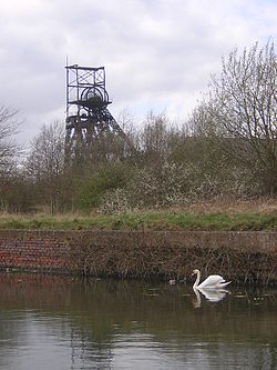
The Pilkington Colliery Company began construction of the colliery in 1908, and the site opened for coal production in 1912. The colliery was closed in 1970 and is now Astley Green Colliery Museum. Most of the buildings associated with the colliery have been destroyed as has one of the mine shafts. [3] [106]
Ringley Old Bridge in Ringley Ringley old bridge.jpg
Ringley Old Bridge in Ringley

Affetside Cross replaced an earlier medieval cross Affetside Cross.jpg
Affetside Cross replaced an earlier medieval cross

The standing remains of Radcliffe Tower Radcliffe tower hdr.jpg
The standing remains of Radcliffe Tower

The 14th-century Baguley Hall, in Baguley is also a Grade I listed building Baguley Hall.jpg
The 14th-century Baguley Hall, in Baguley is also a Grade I listed building

Clayton Hall, in Clayton is also a Grade II* listed building Clayton Hall in 2005.jpg
Clayton Hall, in Clayton is also a Grade II* listed building

A reconstructed section of the wall of Mamucium fort Mancunium.jpg
A reconstructed section of the wall of Mamucium fort

Hanging Bridge was excavated in 1892 Hanging Bridge 1892.jpg
Hanging Bridge was excavated in 1892

Looking west along Nico Ditch, near Levenshulme NicoDitch.jpg
Looking west along Nico Ditch, near Levenshulme

A plan of Castleshaw drawn by Thomas Percival in 1752 showing the fort and the later fortlet Castleshaw plan 1752.jpg
A plan of Castleshaw drawn by Thomas Percival in 1752 showing the fort and the later fortlet

Worsley Delph Worsley delph 2.jpg
Worsley Delph

The Marple Aqueduct crossing the River Goyt Marple Aqueduct 2003.jpg
The Marple Aqueduct crossing the River Goyt

View of Buckton Castle from below View of Buckton Castle from below.jpg
View of Buckton Castle from below

Astley Green Colliery's pithead, viewed from across the Bridgewater Canal AstleyGreenCollieryPithead.jpg
Astley Green Colliery's pithead, viewed from across the Bridgewater Canal

Winstanley Hall, a Tudor house, is also a Grade II* listed building Winstanley Hall 2006.jpg
Winstanley Hall, a Tudor house, is also a Grade II* listed building

Mab's Cross is a Grade II* listed building Mab's Cross 2005.jpg
Mab's Cross is a Grade II* listed building

See also

Notes

A Most references are to one main body of sources: Pastscape which is funded by English Heritage and has information on nearly 400,000 archaeological sites and buildings in England.

"The information on PastScape is derived from the National Monuments Record database which holds records on the architectural and archaeological heritage of England. The National Monuments Record is the public archive of English Heritage." [107]

B Nico Ditch is a linear earthwork that runs for about 6 miles (9.7 km) generally east to west. It forms part of the Manchester Tameside border and the Manchester Stockport border. It passes through Tameside and Manchester and extends into Trafford as far as Stretford. A 135 m (443 ft) long stretch of the ditch in Platt Fields is protected. [31] [32]

References

  1. The Schedule of Monuments, Pastscape.org.uk, archived from the original on 23 February 2009, retrieved 4 February 2009
  2. 1 2 "Scheduled Monuments". Historic England. Retrieved 7 December 2021.
  3. 1 2 Historic England. "Astley Green Colliery: engine house and headgear (1017061)". National Heritage List for England . Retrieved 7 January 2026.
  4. 1 2 Historic England. "Buckton Castle: a ringwork and site of 17th century beacon 350m north east of Castle Farm (1015131)". National Heritage List for England. Retrieved 7 January 2026.
  5. 1 2 Historic England. "Watch Hill motte and bailey castle, 450m south of Streethead Farm (1014377)". National Heritage List for England. Retrieved 7 January 2026.
  6. 1 2 Historic England. "Medieval moated site and later fortified manor house known as Bury Castle 100m west of the parish church (1015128)". National Heritage List for England. Retrieved 7 January 2026.
  7. 1 2 Historic England. "Radcliffe Tower and site of hall 100m south west of the parish church in Radcliffe (1014721)". National Heritage List for England. Retrieved 7 January 2026.
  8. Friar (2003), pp. 186–87.
  9. 1 2 Historic England. "Marple aqueduct (1001954)". National Heritage List for England. Retrieved 7 January 2026.
  10. 1 2 Historic England. "Oldknow's limekilns, Strines Road (1001955)". National Heritage List for England. Retrieved 7 January 2026.
  11. 1 2 Historic England. "Canal tunnel entrances and wharf (1001956)". National Heritage List for England. Retrieved 7 January 2026.
  12. Historic England. "Round cairn 280m west of Old Harpers Farm (1008907)". National Heritage List for England. Retrieved 15 August 2025.
  13. Historic England, "Stone circle, ring cairn and two round cairns on Cheetham Close (1009121)", National Heritage List for England, retrieved 7 January 2026
  14. Historic England, "Moated site at Arley Hall, Haigh near Wigan (1014722)", National Heritage List for England, retrieved 7 January 2026
  15. Historic England, "Smithills Hall (43437)", Research records (formerly PastScape), retrieved 1 February 2009
  16. Historic England, "Smithills Hall Fold (Grade I) (1388279)", National Heritage List for England, retrieved 7 January 2026
  17. Historic England, "Ringley Old Bridge (44221)", Research records (formerly PastScape), retrieved 1 February 2009
  18. Historic England, "Ringley Old Bridge (1001957)", National Heritage List for England, retrieved 7 January 2026
  19. Historic England, "Ringley Old Bridge (Grade II*) (1356800)", National Heritage List for England, retrieved 1 February 2009
  20. Historic England, "Chequerbent embankment of Bolton and Leigh Railway (1479269)", National Heritage List for England, retrieved 7 January 2026
  21. Historic England, "Castlesteads (44369)", Research records (formerly PastScape), retrieved 30 December 2007
  22. Historic England. "Promontory fort called Castlesteads on the east bank of the Irwell 550m SSE of Banks Farm (1014720)". National Heritage List for England. Retrieved 7 January 2026.
  23. Historic England, "Radcliffe Tower (44210)", Research records (formerly PastScape), retrieved 30 December 2007
  24. The parish of Radcliffe, A History of the County of Lancaster: Volume 5 (1911), pp. 5667. URL: http://www.british-history.ac.uk/report.aspx?compid=53000, retrieved on 25 October 2008
  25. Historic England, "Affetside Cross (44366)", Research records (formerly PastScape), retrieved 30 December 2007
  26. Historic England. "Affetside Cross at Affetside 75m north west of the Pack Horse Inn (1014120)". National Heritage List for England. Retrieved 7 January 2026.
  27. Historic England, "Mamucium Roman fort (76731)", Research records (formerly PastScape), retrieved 30 December 2007
  28. Norman Redhead (20 April 2008), A guide to Mamucium, BBC Online, retrieved 20 July 2008
  29. Gregory (2007), pp. 3, 22, 156, 190.
  30. Historic England, "Remains of eastern wall of the Roman fort (1001953)", National Heritage List for England, retrieved 7 January 2026
  31. 1 2 Historic England, "Nico Ditch (1033812)", Research records (formerly PastScape), retrieved 11 February 2009
  32. 1 2 Nevell (1992), p. 77–83.
  33. Historic England, "Section of an early medieval boundary ditch known as the Nico Ditch in Platt Fields 480m SSE of Platt Hall (1015132)", National Heritage List for England, retrieved 7 January 2026
  34. Historic England, "Baguley Hall (76516)", Research records (formerly PastScape), retrieved 5 February 2009
  35. Baguley Hall, Hall Lane, English Heritage , retrieved 5 February 2009[ dead link ]
  36. Historic England, "Baguley Hall (Grade I) (1291962)", National Heritage List for England, retrieved 5 February 2009
  37. Hatmaker, Julia (25 November 2025). "New owners for Wythenshawe's medieval Baguley Hall". Place North West. Retrieved 7 January 2026.
  38. Historic England, "Peel Hall (76526)", Research records (formerly PastScape), retrieved 30 December 2007
  39. Historic England, "Peel Hall moated site (1017861)", National Heritage List for England, retrieved 7 January 2026
  40. Historic England, "Hanging Bridge over Hanging Ditch (76682)", Research records (formerly PastScape), retrieved 30 December 2007
  41. Bridge to Manchester's past revealed, BBC, 18 December 2001, retrieved 4 April 2008
  42. Cooper (2003), p. 52.
  43. Historic England, "The Hanging Bridge immediately south of Manchester Cathedral (1020983)", National Heritage List for England, retrieved 7 January 2026
  44. Historic England, "Clayton Hall (76619)", Research records (formerly PastScape), retrieved 5 February 2009
  45. Historic England, "Clayton Hall (Grade II*) (1197795)", National Heritage List for England, retrieved 7 January 2026
  46. Historic England, "Clayton Hall moated site (1009339)", National Heritage List for England, retrieved 7 January 2026
  47. Historic England, "Bowl Barrow (45895)", Research records (formerly PastScape), retrieved 1 February 2009
  48. Historic England. "Bowl barrow 190m NNE of Knarr Barn (1011681)". National Heritage List for England. Retrieved 7 January 2026.
  49. Historic England, "Rigodunum Roman fort (45891)", Research records (formerly PastScape), retrieved 30 December 2007
  50. Walker (1989), p. 20.
  51. Redhead (1999), pp. 74–81.
  52. Nevell and Redhead (2005), p. 59.
  53. Brennaud (2006), p. 65.
  54. Historic England. "Castleshaw Roman forts, 250m west of Castle Shaw Farm (1017837)". National Heritage List for England. Retrieved 7 January 2026.
  55. Historic England. "Blackstone Edge Roman road See also Greater Manchester 5 (1005819)". National Heritage List for England. Retrieved 7 January 2026.
  56. "The Old Roman Road Over Blackstone Edge". Calderdale Council. Retrieved 7 January 2026.
  57. Ratledge, David (April 2018). "The Supposed Roman Road over Blackstone Edge". Roman Roads Research Association. Retrieved 7 January 2026.
  58. Historic England. "March Barn Bridge, Rochdale Canal (1005559)". National Heritage List for England. Retrieved 7 January 2026.
  59. "Virtual Journey along the Rochdale Canal - Rochdale to Manchester (2)". Pennine Waterways. Retrieved 7 January 2026.
  60. Historic England, "Monument No. 73547", Research records (formerly PastScape), retrieved 5 February 2009
  61. Historic England. "Promontory fort 300m west of Great Woolden Hall Farm (1015127)". National Heritage List for England. Retrieved 7 January 2026.
  62. Historic England. "Wardley Hall moated site, Worsley (1014725)". National Heritage List for England. Retrieved 7 January 2026.
  63. Historic England, "Duke Of Bridgewaters Underground Canals (44278)", Research records (formerly PastScape), retrieved 30 December 2007
  64. Historic England. "Bridgewater Canal's Barton Aqueduct embankment and retaining walls (1470478)". National Heritage List for England. Retrieved 7 January 2026.
  65. Historic England. "Lime kiln and associated culvert 50m north of Worsley Methodist Church (1427469)". National Heritage List for England. Retrieved 7 January 2026.
  66. Historic England, "Brown Low (78554)", Research records (formerly PastScape), retrieved 4 February 2009
  67. Historic England. "Brown Low bowl barrow (1010823)". National Heritage List for England. Retrieved 7 January 2026.
  68. Historic England, "Bronze Age cairn in Ludworth (890910)", Research records (formerly PastScape), retrieved 4 January 2008
  69. Historic England. "Cairn on Ludworth Intakes (1008596)". National Heritage List for England. Retrieved 7 January 2026.
  70. Historic England, "Peel Hall, Stockport (76845)", Research records (formerly PastScape), retrieved 5 February 2009
  71. Historic England. "Peel Moat (1011674)". National Heritage List for England. Retrieved 7 January 2026.
  72. Historic England, "Torkington Moat (78351)", Research records (formerly PastScape), retrieved 5 February 2009
  73. Historic England. "Moated site north-west of Broadoak Farm (1009864)". National Heritage List for England. Retrieved 7 January 2026.
  74. Historic England, "Oldknows Limekilns (78346)", Research records (formerly PastScape), retrieved 5 February 2009
  75. Historic England, "Walling at old lime kiln, behind number 32 (Grade II) (1242485)", National Heritage List for England, retrieved 7 January 2026
  76. Historic England, "Marple Goyt Aqueduct (78557)", Research records (formerly PastScape), retrieved 4 February 2009
  77. Historic England, "Monument No. 78454", Research records (formerly PastScape), retrieved 1 February 2009
  78. Historic England, "Round cairn west of Hollingworthhall Moor (1011682)", National Heritage List for England, retrieved 7 January 2026
  79. Historic England, "Section of an early medieval boundary ditch known as the Nico Ditch on Denton golf course 320m south west of Lodge Farm (1016197)", National Heritage List for England, retrieved 7 January 2026
  80. Nevell (1998), pp. 6061, 63.
  81. P. Booth, M. Harrop & S. Harrop, The Extent of Longdendale, 1360, Cheshire Sheaf, 5th series, #83
  82. Grimsditch, Nevell, and Redhead (2007), pp. 5, 16.
  83. Grimsditch, Nevell & Nevell (2012), pp. 8285.
  84. Historic England, "Post-medieval glassworks 250m south east of Clarke's Bridge (1020704)", National Heritage List for England, retrieved 7 January 2026
  85. Historic England, "Watch Hill Castle (74893)", Research records (formerly PastScape), retrieved 30 December 2007
  86. Nevell (1997), pp. 27, 34.
  87. Historic England, "Cross base at junction of Green Lane, Standish Wood Lane and Beech Walk, Standish (41980)", Research records (formerly PastScape), retrieved 5 February 2009
  88. Historic England, "Cross base on Green Lane, Standish (41983)", Research records (formerly PastScape), retrieved 5 February 2009
  89. Historic England, "Cross base (1287159)", National Heritage List for England, retrieved 5 February 2009
  90. Historic England, "Cross base on Standish Wood Lane, Standish (41972)", Research records (formerly PastScape), retrieved 30 December 2007
  91. Historic England, "Morleys Hall (73466)", Research records (formerly PastScape), retrieved 5 February 2009
  92. Historic England, "Morley's Hall (Grade II*) (1318255)", National Heritage List for England, retrieved 5 February 2009
  93. Historic England, "Market Cross (42326)", Research records (formerly PastScape), retrieved 5 February 2009
  94. Historic England, "Village cross and stocks (Grade II) (1228471)", National Heritage List for England, retrieved 7 January 2026
  95. Historic England, "Mab's Cross (41800)", Research records (formerly PastScape), retrieved 6 February 2009
  96. Historic England, "Mabs Cross (Grade II*) (1384526)", National Heritage List for England, retrieved 7 January 2026
  97. Historic England, "New Hall (43339)", Research records (formerly PastScape), retrieved 6 February 2009
  98. Historic England, "Winstanley Hall (42086)", Research records (formerly PastScape), retrieved 6 February 2009
  99. Historic England, "Winstanley Hall (Grade II*) (1287365)", National Heritage List for England, retrieved 6 February 2009
  100. Scheduled Ancient Monuments in Wigan, Wigan.gov.uk, archived from the original on 6 March 2007, retrieved 5 February 2009
  101. Newsletter #52, Wigan Archaeological Society, April 2002, retrieved 6 February 2009
  102. Historic England, "Gidlow Hall (43321)", Research records (formerly PastScape), retrieved 6 February 2009
  103. Historic England, "Gidlow Hall (Grade II) (1068430)", National Heritage List for England, retrieved 6 February 2009
  104. Historic England, "Haigh Sough mine drainage portal (41959)", Research records (formerly PastScape), retrieved 30 December 2007
  105. Historic England, "The Moat House (43314)", Research records (formerly PastScape), retrieved 5 February 2009
  106. Historic England, "Astley Green Colliery (623407)", Research records (formerly PastScape), retrieved 5 February 2009
  107. About PastScape, Pastscape.org.uk, retrieved 30 December 2007

Bibliography

  • Brennand, Mark, ed. (2006), The Archaeology of North West England, Council for Archaeology North West, ISSN   0962-4201
  • Cooper, Glynis (2003), Hidden Manchester, Breedon Books Publishing, ISBN   1-85983-401-9
  • Friar, Stephen (2003), The Sutton Companion to Castles, Stroud: Sutton Publishing, ISBN   978-0-7509-3994-2
  • Gregory, Richard, ed. (2007), Roman Manchester: The University of Manchester's Excavations within the Vicus 20015, Oxford: Oxbow Books, ISBN   978-1-84217-271-1
  • Grimsditch, Brian; Nevell, Mike; Redhead, Norman (September 2007), Buckton Castle: An Archaeological Evaluation of a Medieval Ringwork – an Interim Report, University of Manchester Archaeological Unit
  • Grimsditch, Brian; Nevell, Michael; Nevell, Richard (2012), Buckton Castle and the Castles of North West England, University of Salford Archaeological Monographs volume 2 and the Archaeology of Tameside volume 9, Centre for Applied Archaeology, School of the Built Environment, University of Salford, ISBN   978-0-9565947-2-3
  • Nevell, Mike (1992), Tameside Before 1066, Tameside Metropolitan Borough Council, ISBN   1-871324-07-6
  • Nevell, Mike (1997), The Archaeology of Trafford, Trafford Metropolitan Borough with University of Manchester Archaeological Unit, ISBN   1-870695-25-9
  • Nevell, Mike (1998), Lands and Lordships in Tameside, Tameside Metropolitan Borough Council with the University of Manchester Archaeological Unit, ISBN   1-871324-18-1
  • Nevell, Mike; Redhead, Norman (2005), Mellor: Living on the Edge. A Regional Study of an Iron Age and Romano-British Upland Settlement, University of Manchester Archaeological Unit, Greater Manchester Archaeological Unit, and the Mellor Archaeological Trust, ISBN   0-9527813-6-0
  • Walker, John, ed. (1989), Castleshaw: The Archaeology of a Roman Fortlet, Greater Manchester Archaeological Unit, ISBN   0-946126-08-9