The Manchester Bolton & Bury Canal is a disused canal in Greater Manchester, England, built to link Bolton and Bury with Manchester. The canal, when fully opened, was 15 miles 1 furlong (24 km) long. It was accessed via a junction with the River Irwell in Salford. Seventeen locks were required to climb to the summit as it passed through Pendleton, heading northwest to Prestolee before it split northwest to Bolton and northeast to Bury. Between Bolton and Bury the canal was level and required no locks. Six aqueducts were built to allow the canal to cross the rivers Irwell and Tonge and several minor roads.

Bolton is a large town in Greater Manchester in North West England, historically and traditionally a part of Lancashire. A former mill town, Bolton has been a production centre for textiles since Flemish weavers settled in the area in the 14th century, introducing a wool and cotton-weaving tradition. The urbanisation and development of the town largely coincided with the introduction of textile manufacture during the Industrial Revolution. Bolton was a 19th-century boomtown and, at its zenith in 1929, its 216 cotton mills and 26 bleaching and dyeing works made it one of the largest and most productive centres of cotton spinning in the world. The British cotton industry declined sharply after the First World War and, by the 1980s, cotton manufacture had virtually ceased in Bolton.

Farnworth is a town in the Metropolitan Borough of Bolton, Greater Manchester, England, 2.3 miles (3.7 km) southeast of Bolton, 4.3 miles south-west of Bury (7 km), and 7.5 miles (12.1 km) northwest of Manchester.

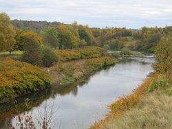
The River Irwell is a tributary of the River Mersey in north west England. It rises at Irwell Springs on Deerplay Moor, approximately 1+1⁄2 miles north of Bacup and flows southwards for 39 mi (63 km) to meet the Mersey near Irlam. The Irwell marks the boundary between Manchester and Salford, and its lower reaches have been canalised and now form part of the Manchester Ship Canal.

Pendlebury is a town in the City of Salford, Greater Manchester, England. The population at the 2011 Census was 13,069. It lies 4.1 miles (6.6 km) northwest of Manchester city centre, 3.4 miles (5.5 km) northwest of Salford, and 5.9 miles (9.5 km) southeast of Bolton.

Little Lever is a town in the Metropolitan Borough of Bolton, Greater Manchester, England. Historically in Lancashire, it is 2.4 miles (3.9 km) southeast of Bolton, 1.9 miles (3.1 km) west of Radcliffe and 4 miles (6.4 km) southwest of Bury. In the 19th century, the population was employed in cotton mills, paper mills, bleach works, terracotta works, a rope works and numerous collieries.
Darcy Lever is an area of the Metropolitan Borough of Bolton in Greater Manchester, England. Historically part of Lancashire, the area lies on the B6209, between Bolton and Little Lever. Its history dates to the time of William the Conqueror when it was part of the Salford Hundred given to Roger of Poitou for his participation in the Norman conquest of England.

Kearsley is a town in the Metropolitan Borough of Bolton, Greater Manchester, England. The population at the 2011 census was 14,212. Historically part of Lancashire, it lies 8 miles (13 km) northwest of Manchester, 5 miles (8 km) southwest of Bury and 3+3⁄4 miles (6 km) south of Bolton.

Halliwell is predominantly a residential area of Bolton, Greater Manchester, England. It gives its name to an electoral ward of the wider Metropolitan Borough of Bolton. The population of this ward taken at the 2011 census was 13,929. Halliwell lies about 2 miles (3.2 km) to the north west of Bolton town centre and is bounded by Tonge Moor to the east and Heaton to the south west. Smithills Hall to the north is within the ancient township. It lies on the lower south facing slopes of the West Pennine Moors.
Burnden is a district in the town of Bolton in Greater Manchester, England. It is located about 1 mile (2 km) southeast of Bolton town centre.
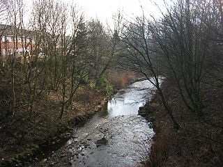
The River Tonge is a short river, splitting Bolton from contiguous Tonge, both in Greater Manchester, England.

Eagley Brook is a small river of Lancashire and Greater Manchester in England.

Dean Brook is a river in Smithills, Bolton, Greater Manchester, historically within Lancashire.

Bradshaw Brook is a river draining parts of Lancashire and Greater Manchester in Northern England.
Heaton is mostly a residential district of Bolton, Greater Manchester, England. It lies about 2 miles (3 km) north west of Bolton town centre. It is bounded by Deane to the south, Markland Hill to the west, and Smithills and Halliwell to the north.

Moses Gate Country Park, part of which is also known as Crompton Lodges, is a 750 acre site situated at Moses Gate in the Croal and Irwell Valleys 3 miles south of Bolton town centre on the A6053 road which connects Farnworth to Little Lever. It is a Local Nature Reserve.
Moses Gate is a small district of Farnworth, in the Metropolitan Borough of Bolton, Greater Manchester, England. Historically in Lancashire, it lies 2.6 miles (4.2 km) southeast of Bolton town centre and 10.8 miles (17.4 km) northwest of the city of Manchester.
Rumworth is an electoral ward of Bolton, in Greater Manchester, England. The population of this ward at the 2011 census was 16,250. Historically it was part of the hundred of Salford in Lancashire and centre of the Parish of Deane which once covered roughly half of the present Metropolitan Borough of Bolton. St Mary's Church on which the parish was centred was in the township of Rumworth.
Great Bolton was a township of the civil and ecclesiastical parish of Bolton le Moors in the Salford hundred of Lancashire, England. Despite its name, Great Bolton had a smaller acreage than its northern neighbour Little Bolton from which it was separated by the River Croal.

The Church of St Mary the Virgin, Deane, is an Anglican parish church in Deane, Bolton, Greater Manchester, England. It is a member of Deane deanery in the archdeaconry of Bolton, diocese of Manchester. It is a Grade II* listed building.