Middlebrook, Greater Manchester

Last updated

Middlebrook
Parking Lot in Middlebrook Retail Park.jpg
Middlebrook Retail Park
Greater Manchester UK location map 2.svg
Red pog.svg
Middlebrook
Location within Greater Manchester
OS grid reference SD645094
Metropolitan borough
Metropolitan county
Region
Country England
Sovereign state United Kingdom
Post town BOLTON
Postcode district BL6
Dialling code 01204
Police Greater Manchester
Fire Greater Manchester
Ambulance North West
UK Parliament
List of places
UK
England
Greater Manchester
53°34′48″N2°32′06″W / 53.580°N 2.535°W / 53.580; -2.535 Coordinates: 53°34′48″N2°32′06″W / 53.580°N 2.535°W / 53.580; -2.535

Middlebrook is a locality that spans the boundaries of Horwich and Lostock in the Metropolitan Borough of Bolton, Greater Manchester, England (historically a part of Lancashire).

Contents

The name Middlebrook is derived from the watercourse the Middle Brook which starts at Red Moss, the mossland south of Horwich. Further downstream the Middle Brook joins with other tributaries and becomes the River Croal which runs through Bolton and eventually joins the River Irwell at Kearsley.

Middlebrook is an out of town complex of retail, leisure and business parks and location of the University of Bolton Stadium, home of Bolton Wanderers F.C., and Horwich Police Station.

History

The name Middlebrook (or Middle Brook) comes from the Old English words "mycel" and "broc" meaning "great brook". In 1292, the name was written "Mikelbrok" and over the centuries it became Middlebrook. [1]

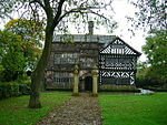
Before the retail, leisure and business parks were built Middlebrook was the site of Sefton Fold Farm in Horwich. The old timber framed farmhouse with sandstone flag roof as could have been seen latterly would seem to have dated from the 16th century with many intervening changes.

The floor plan would indicate a three bay farmhouse or hall: the latter access being a 'baffle' entry facing the central chimney stack; this may have also been the original position but could have been a more traditional 'screens' entrance adjacent to the service bay.

A cellar appears to have been located under the northern service bay and later GMAU investigations would infer that this used to be occupied by a small water wheel (for grinding domestic crops?)

That would also infer that a stream ran under the house at this point. A well existed very nearby in the yard but any evidence of a stream latterly had become obscured. Something of a rebuild appears to have happened around 1666 and was possibly refaced or altered in 1811, as evidenced by the semi circular datestone over the adjacent cottage which dates from 1811. However, an earlier late Georgian brick wing was seemingly added before that date, the bricks having been locally 'clamped'.

The old bay (parlour) closest to the 'new wing' as described had already had its wattle and daub removed and replaced with brick. The middle bay (housebody) and end bay (service) together with the north gable had been rebuilt in 'watershot' squared and coursed gritstone rubble, although when that happened is not clear, because the stone of the adjacent 1811 cottage was constructed from thinner, flaggy sandstone and not watershot.

The rear of the range was extended, evidently in the 19th century, from random sandstone rubble walling under a full 'catslide' stone flag roof, and this extension had a floor over creating a loft: this loft was accessed from the first floor and was laid with compressed straw and other material.

Floorboards upstairs in the main range were butt jointed and wide, of random size; some doorleaf stiles and rails were reed moulded and mortise framed and simply panelled, indicating 17th century origin. The floor over the 'housebody' was a much later addition to the original, being supported off separate beams running parallel to the long walls and resting on inserted brackets or 'corbels'.

The mortises and pegholes to the former arch bracing to the central house frame could still be seen, identifying that this part of the house was possibly originally double height, or at least, the floor was set much higher than latterly, rendering the upper floor of poor usage.

There is also the presence of a vestige of a wattle and daub 'fire hood', a forerunner of a later brick chimney stack. The opening to one side of the chimney stack upstairs was blocked up economically in brick on edge, the bricks were machine pressed with 'frogs' and bore the text 'Yates Plastic Horwich'. Much of the original timber framing remained within the rear 'outshut' including a former unglazed window complete with Oak stave mullions. the timber framing was set upon a high sandstone plinth, the same remained on the main frontage under the brick infill to the 'parlour' bay.

The complete wallplate remained over the rebuilt main east facade and exhibited all the original mortises and peg holes from the original framing, so a reasonable guess could be made at the appearance of the building. the timbers in the 'outshut' were all reused and exhibited peg holes, mortises and carpenters' marks.

There is a case for supposing that these were taken from the timbers replaced by the later stonework, and one beam in particular hinted at coming from the old north gable truss chord, due to its size and moulding. Other evidence in the timbers points at herringbone patterning within the framing, which would reflect the regional trend for such decoration. (these detailed notes modified and expanded by Mark Head, who surveyed the house in about 1985).

Before demolition in 1996, the University of Manchester's Archaeological Unit spent three weeks on the Sefton Fold Farm site. The team excavated a moated site of late medieval origins and pottery believed to date from the late 16th or early 17th centuries was found. [2] When development started, the site was partly covered by a roundabout. The farmhouse's 1666/1811 date stone, 1860s cooking range and other items were saved and can be seen at the Heritage Centre in Horwich. [3]

Development

Emerson Group began developing the two hundred acre Middlebrook retail, leisure and business complex [4] started in 1996, and the first businesses were operating from the site in 1998. The out of town retail centre, contains retail shops and stores, a twelve screen cinema, ten-pin bowling alley, cafés and restaurants, two hotels, and the Bolton Arena Sports & Leisure Complex. Horwich Police Station is located on Burnden Way at the Middlebrook site. [5]

At the centre of the site is the University of Bolton Stadium (formerly Macron Stadium and previously Reebok Stadium), home of Bolton Wanderers F.C. which was inaugurated on 1 September 1997, when the first game between Bolton and Everton was played.

Transport

The Middlebrook site is adjacent to Junction 6 of the M61 motorway. The A6027 connects the A6 with the motorway, the retail and business parks and the A673 road to Horwich and Bolton. There is a regular train service provided by Northern at Horwich Parkway railway station where there is a Park and Ride facility with trains to Bolton, Manchester and Preston. There are also bus services which include the 516/ 517 from Leigh and 574/ 576/ 577, also from Bolton.

Related Research Articles

Timber framing Traditional building technique

Timber framing and "post-and-beam" construction are traditional methods of building with heavy timbers, creating structures using squared-off and carefully fitted and joined timbers with joints secured by large wooden pegs. If the structural frame of load-bearing timber is left exposed on the exterior of the building it may be referred to as half-timbered, and in many cases the infill between timbers will be used for decorative effect. The country most known for this kind of architecture is Germany, where timber-framed houses are spread all over the country.

Boscobel House

Boscobel House is a Grade II* listed building in the parish of Boscobel in Shropshire. It has been, at various times, a farmhouse, a hunting lodge, and a holiday home; but it is most famous for its role in the escape of Charles II after the Battle of Worcester in 1651. Today it is managed by English Heritage.

Horwich Human settlement in England

Horwich is a town and civil parish in the Metropolitan Borough of Bolton, Greater Manchester, England. Within the boundaries of the historic county of Lancashire, it is 5.3 miles (8.5 km) southeast of Chorley, 5.8 miles (9.3 km) northwest of Bolton and 15 miles (24 km) northwest of Manchester. It lies at the southern edge of the West Pennine Moors with the M61 motorway passing close to the south and west. At the 2011 Census, Horwich had a population of 20,067.

Horwich Parkway railway station Railway station in Greater Manchester, England

Horwich Parkway is a railway station serving the town of Horwich and Middlebrook near Bolton, in Greater Manchester, England. Located within the historic county of Lancashire the station is 16+14 miles (26.2 km) north west of Manchester Piccadilly on the Manchester to Preston commuter line. The station is close to Junction 6 of the M61 motorway which adds to its convenience as a park and ride railway station. It has digital information displays.

Weald and Downland Living Museum Open-air living museum

The Weald and Downland Living Museum is an open-air museum in Singleton, West Sussex. The museum is a registered charity.

Peckforton Human settlement in England

Peckforton is a scattered settlement and civil parish in the unitary authority of Cheshire East and the ceremonial county of Cheshire, England. The settlement is located 6.5 miles (10.5 km) to the north east of Malpas and 7.5 miles (12.1 km) to the west of Nantwich. The civil parish covers 1,754 acres (710 ha), with an estimated total population of 150 in 2006. The area is predominantly agricultural. Nearby villages include Bulkeley to the south, Beeston to the north, Higher Burwardsley to the west, Spurstow to the east and Bunbury to the north east.

Blackstone, West Sussex Human settlement in England

Blackstone is a hamlet in the civil parish of Woodmancote and the Horsham district of West Sussex, England. Blackstone is significant for its listed 17th- and 18th-century houses and cottages.

Mitchell – Foster – Young House United States historic place

The Mitchell – Foster – Young House is a historic house located just outside Oxford, Mississippi off the highway to New Albany. The house, thought to be one of the oldest standing farmhouses in the county, is listed on the National Register of Historic Places.

Chevington, Suffolk Human settlement in England

Chevington is a village and civil parish in the West Suffolk district of Suffolk in East Anglia, England. Located around 10 km south-west of Bury St Edmunds, in 2005 its population was 630, reducing to 602 at the 2011 Census. The parish also contains the hamlets of Broad Green and Tan Office Green.

Wealden hall house

The Wealden hall house is a type of vernacular medieval timber-framed hall house traditional in the south east of England. Typically built for a yeoman, it is most common in Kent and the east of Sussex but has also been built elsewhere. Kent has one of the highest concentrations of such surviving medieval timber framed buildings in Europe.

Eccleston Ferry House

Eccleston Ferry House is a farmhouse to the southeast of the village of Eccleston, Cheshire, England. It is situated on the east bank of the River Dee near the site of an ancient ferry crossing of the river The house is recorded in the National Heritage List for England as a designated Grade II listed building.

Saighton Lane Farm

Saighton Lane Farm is a farm, originating as a model farm, in Saighton Lane, 0.5 miles (1 km) to the north-northeast of the village of Saighton, Cheshire, England. The farmhouse and the farm buildings are recorded separately in the National Heritage List for England as designated Grade II listed buildings.

Hall house Vernacular house typical of Britain, centred on a hall

The hall house is a type of vernacular house traditional in many parts of England, Wales, Ireland and lowland Scotland, as well as northern Europe, during the Middle Ages, centring on a hall. Usually timber-framed, some high status examples were built in stone.

The Lack, Brompton

The Lack is a Grade II* Listed Building, formerly in the historic parish of Churchstoke but now in the parish of Chirbury with Brompton in Shropshire. It is likely to have been built in the latter part of the 16th century.

Fachwerk Farmhouse

Fachwerk Farmhouse is a heritage-listed farmhouse at 445 – 469 Beenleigh Redland Bay Rd, Carbrook, City of Logan, Queensland, Australia. It was built c. 1873 by August Von Senden. It is also known as Krugers Farm. It was added to the Queensland Heritage Register on 7 February 2005.

Robert Raikes House

Robert Raikes' House is an historic 16th century timber-framed town house at 36-38 Southgate Street, Gloucester. It is now used as a public house called the Robert Raikes Inn.

Muswellbrook Post Office

Muswellbrook Post Office is a heritage-listed post office at 7 Bridge Street, Muswellbrook, New South Wales, Australia. It was added to the Australian Commonwealth Heritage List on 08 November 2011.

Warwick Post Office

Warwick Post Office is a heritage-listed post office at 98 Palmerin Street, Warwick, Southern Downs Region, Queensland, Australia. It was designed by Queensland Government Architect Alfred Barton Brady and was built in 1898. It was added to the Australian Commonwealth Heritage List on 8 November 2011.

Old Mining Museum Building

The Old Mining Museum building is a heritage-listed former chemical laboratory and mining museum and now commercial building located at 36-64 George Street in the inner city Sydney suburb of The Rocks in the City of Sydney local government area of New South Wales, Australia. It was designed by Walter Liberty Vernon and built from 1902 to 1909. It is also known as Mining Museum (former), Earth Exchange and Sydney Geological and Mining Museum. The property is owned by Property NSW, an agency of the Government of New South Wales. It was added to the New South Wales State Heritage Register on 10 May 2002.

Euroa Post Office

Euroa Post Office is a heritage-listed post office at 90 Binney Street, Euroa, Victoria, Australia. It was designed by John Thomas Kelleher of the state Public Works Department, possibly with the assistance of A. J. McDonald, and built in 1890 by George Diggle. It was added to the Australian Commonwealth Heritage List on 22 August 2012.

References

  1. Billington, W.D. (1982). From Affetside to Yarrow : Bolton place names and their history, Ross Anderson Publications ( ISBN   0-86360-003-4).
  2. Bolton Evening News - Sefton Fold Farm Archived 2007-09-28 at the Wayback Machine . URL accessed 8 April 2007.
  3. Horwich Heritage Centre. URL accessed 5 October 2008.
  4. Middlebrook Bolton, Middlebrook, retrieved 30 November 2010
  5. Welcome to Horwich and Blackrod, Bolton North. URL accessed 27 May 2007.