
Taunton is the county town of Somerset, England. It is a market town and has a minster church. Its population in 2011 was 64,621. Its thousand-year history includes a 10th-century monastic foundation, owned by the Bishops of Winchester, which was rebuilt as Taunton Castle by the Normans in the 12th century. Parts of the inner ward house were turned into the Museum of Somerset and Somerset Military Museum. For the Second Cornish uprising of 1497, Perkin Warbeck brought an army of 6,000; most surrendered to Henry VII on 4 October 1497. On 20 June 1685 in Taunton the Duke of Monmouth crowned himself King of England in a rebellion, defeated at the Battle of Sedgemoor. Judge Jeffreys led the Bloody Assizes in the Castle's Great Hall.
Basingstoke is a town in Hampshire, situated in south-central England across a valley at the source of the River Loddon on the western edge of the North Downs. It is the largest settlement in Hampshire without city status. It is located 30 miles (48 km) north-east of Southampton, 48 miles (77 km) south-west of London, 27 miles (43 km) west of Guildford, 22 miles (35 km) south of Reading and 20 miles (32 km) north-east of the county town and former capital Winchester. According to the 2016 population estimate, the town had a population of 113,776. It is part of the borough of Basingstoke and Deane and part of the parliamentary constituency of Basingstoke.

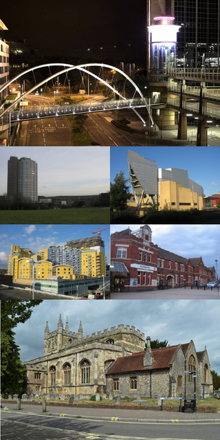
Bolton is a town in Greater Manchester in England. In the foothills of the West Pennine Moors, Bolton is between Manchester, Blackburn, Wigan, Bury and Salford. It is surrounded by several towns and villages that form the wider borough, of which Bolton is the administrative centre. The town is within the historic county boundaries of Lancashire.
Sedgley is a town in the north of the Metropolitan Borough of Dudley, in the West Midlands, England.

Farnworth is a town in the Metropolitan Borough of Bolton, Greater Manchester, England, 2 miles (3.2 km) southeast of Bolton, 4 miles south-west of Bury (7 km), and 8 miles (12.9 km) northwest of Manchester.

The University of Bolton, Bolton University or UoB is a public university in Bolton, Greater Manchester, England. The University is commonly referred to as a 'post-92' institution, which is a reference to the Further and Higher Education Act 1992. It has approximately 11,000 students and more than 900 academic and professional staff.

Horwich is a town and civil parish in the Metropolitan Borough of Bolton, Greater Manchester, England, within the historic county boundaries of Lancashire. It is 5.3 miles (8.5 km) southeast of Chorley, 5.8 miles (9.3 km) northwest of Bolton and 15 miles (24 km) northwest of Manchester. It lies at the southern edge of the West Pennine Moors with the M61 motorway passing close to the south and west. At the 2011 Census, Horwich had a population of 20,067.

Little Lever is a village in the Metropolitan Borough of Bolton, Greater Manchester, England. Within the Historic County of Lancashire, it is 2 miles (3.2 km) southeast of Bolton, 2 miles (3.2 km) west of Radcliffe and 4 miles (6.4 km) southwest of Bury. In the 19th century, the population was employed in cotton mills, paper mills, bleach works, terracotta works, a rope works and numerous collieries.
The Derby High School is a secondary school, located on Radcliffe Road, Bury, Greater Manchester, England. It opened in September 1959 as the Derby Grammar School, a new school that offered both a grammar and a technical education. Some of the pupils moved from Bury High School, a Grammar School on nearby Parliament Street, which closed when the Derby opened. They had gone there having passed the Eleven Plus examination. Other pupils came from Bury Junior Technical School having attended that school from the age of 13 years. The school was formed by merging those two schools into a grammar-technical school. In September 1979 it became a comprehensive school and its sixth form was closed. There are extensive playing fields to the front of the school and the school is easily recognised with its distinctive tower. The school has changed most in the past 15 years with The Derby Sports Centre opening in 2015, Inspire opening First as a boys Sixth form which is now home to Media, Drama, Dance & Music. With the latest building Create replacing the old boys sports hall.

Lostock is a residential district of Bolton, Greater Manchester, England, 3.5 miles (5.6 km) west of Bolton town centre and 13 miles (21 km) northwest of Manchester. Historically part of Lancashire, Lostock is bounded by Deane to the southeast, Markland Hill to the northeast, and Middlebrook to the west. Bolton Wanderers' football ground, the University of Bolton Stadium, is in nearby Horwich.

Walkden is a town in the City of Salford in Greater Manchester, England, six miles northwest of central Salford, and seven miles of Manchester.
Ernulf Academy is a secondary school with academy status, located in St Neots, Cambridgeshire, England. It is one of two St Neots secondary schools that are part of the Astrea Academy Trust, with Longsands Academy being the other.

Dorothy Stringer School is a secondary school located in Brighton, East Sussex, England. It has over 1,600 pupils and 115 members of staff. There are 64 forms, each with an average of 26 students.

Sandringham School is a secondary school with academy status in Marshalswick, St Albans, Hertfordshire. It was established in 1988 following a merger of two local schools, Marshalswick School and Wheathampstead School. It occupies the former Marshalswick site, adjacent to Wheatfields Infant and Junior schools. The former Wheathampstead site was used as a training centre by Hertfordshire County Council until 2007, and has now been redeveloped into housing.

William Edwards School, commonly referred to by locals and students as Willy Eds, is a coeducational secondary comprehensive school with academy status, in Grays, Essex, England. It is a founding member of the South West Essex Community Education Trust (SWECET) and is its leading member. The current headteacher of the school is Simon Bell. The school first opened on 11 September 1962, gained specialist sports college status in 2002 and in 2004 also became a training school. The school achieved outstanding in its Ofsted inspection of December 2010 after which it closed to make way for the current academy status school, reopening on 1 August 2011. In March 2017 the school was inspected and retained outstanding status. As of 2019 it requires improvement.

Dormers Wells or Dormer's Wells is an urban community or neighbourhood in west London, England consisting of a grid of mostly semi-detached or terraced houses with gardens and small parks: in the London Borough of Ealing, and the Southall post town area.

Cheltenham Bournside School and Sixth Form Centre, more commonly referred to as Bournside School or simply Bournside, is a coeducational secondary school and sixth form with academy status, located in Cheltenham, Gloucestershire. The school initially opened as Gloucester Road Elementary School in 1919, going through several different reforms before becoming Cheltenham Bournside School in 1972.
Sir John Hunt Community Sports College is a mixed secondary school and sixth form located in the Whitleigh area of Plymouth in the English county of Devon. The school is named after Sir John Hunt, an army officer who is best known as the leader of the successful 1953 British Expedition to Mount Everest.

Saeed Atcha, is Chief executive of the youth-led charity Youth Leads UK. Atcha is currently a Deputy Lieutenant of Greater Manchester and a Commissioner of the Social Mobility Commission.
