Blackrod

Last updated

Blackrod
St Katharine's Church.jpg
Blackrod's parish church of St Katharine
Greater Manchester UK location map 2.svg
Red pog.svg
Blackrod
Location within Greater Manchester
Population5,001 (2011 Census)
OS grid reference SD615105
  London 177 mi (285 km) SE
Metropolitan borough
Metropolitan county
Region
Country England
Sovereign state United Kingdom
Post town BOLTON
Postcode district BL6
Dialling code 01942/01204
Police Greater Manchester
Fire Greater Manchester
Ambulance North West
UK Parliament
List of places
UK
England
Greater Manchester
53°35′23″N2°34′51″W / 53.5898°N 2.5809°W / 53.5898; -2.5809

Blackrod is a town and civil parish situated within the Metropolitan Borough of Bolton in Greater Manchester, England. Nestled in the historic County of Lancashire, Blackrod is positioned 3.9 miles (6.3 km) northeast of Wigan and 6.6 miles (10.6 km) west of Bolton. According to the United Kingdom Census of 2021, the town has a population of 5,345.

Contents

Blackrod was once a centre for coal mining.

History

The name Blackrod derives from the Old English, blaec and rodu, meaning a "dark clearing". The first mention of the town dates to 1189, when it was recorded as Blacherode. [1] It was recorded as Blakerodein 1200, and Blacrode in 1220. [2] Another suggestion is that "rod" may refer to Holy Rood, Cross of Christ. [3]

Blackrod is reputed to be the site of a Roman station [4] and they built a fort on the northern side of the town, on what is now a residential area called Castle Croft. [5] The A6 road is built along the course of a Roman road that passes below the hill on which the town is built.

In the first half of the 12th century the manor of Blackrod was held by William Peverel, but was confiscated by the king and in 1190 it was granted to Hugh le Norreys. In 1212 Hugh de Blackrod was tenant. In 1223 Hugh Norreys became lord of Blackrod and the manor descended through his family. Mabel Norris heiress of Blackrod and Haigh married Roger de Bradshaw and the manor remained with the Bradshaws until the 16th century. [2]

Arley Hall was an estate in the west of the township held by William le Walsh in 1393 and later by Standishes and Norrises. [2] The hall was a moated manor house and is now the site of Wigan Golf Course.

After the Industrial Revolution the main industry of the town was coal mining and there was a brickworks. In 1869, the collieries operating in Blackrod included Anderton Hall, Dootson Vauze, Park Hall, Rigby Hill, Marklands and Blackrod. [6] The Scot Lane Colliery employed 628 men underground and 122 surface workers in 1923; it closed in 1932. [7] There were formerly bleachworks, a calico-printing works, [4] and a weaving mill was built in 1906.

Governance

Lying within the county boundaries of Lancashire since the early 12th century, Blackrod was a chapelry and township in the ecclesiastical parish of Bolton le Moors in the Hundred of Salford. [8] It was part of the Wigan Poor Law Union which after 1837 took responsibility for the administration and funding of the Poor Law in that area. [9] The Blackrod Local Board of Health was established in 1872 and in 1894 it became Blackrod Urban District. Blackrod was within the administrative county of Lancashire but after the passage of the Local Government Act 1972 the Urban District became part of Bolton Metropolitan Borough in Greater Manchester in 1974. [10]

Blackrod constitutes a civil parish and is served by Blackrod Town Council. [11]

Geography

The village from Winterhill Blackrod Village from Winterhill.jpg
The village from Winterhill

Blackrod lies on hilly ground near the River Douglas, west of the West Pennine Moors, and covers 2,344 acres. [4] It lies west of the M61 motorway, which divides it from Horwich. Besides Blackrod village, the parish includes the small settlements of Little Scotland and Scot Lane End. [12]

Between Blackrod, Lostock and Horwich is Red Moss, a 116.6 acre (47.2 hectare) Site of Special Scientific Interest (SSSI) which was designated in 1995 for its biological interest. Red Moss is the best example of lowland raised mire in Greater Manchester and is one of 21 SSSIs in the area. [13] The site is managed by the Wildlife Trust for Lancashire, Manchester and North Merseyside. [14]

Demography

Population change

Population changes in Blackrod since 1801
YearPopulation±%
1801 1,623    
1811 2,111+30.1%
1821 2,436+15.4%
1831 2,591+6.4%
1841 2,615+0.9%
1851 2,509−4.1%
1861 2,911+16.0%
YearPopulation±%
1871 3,800+30.5%
1881 4,234+11.4%
1891 4,021−5.0%
1901 3,875−3.6%
1911 3,896+0.5%
1921 3,867−0.7%
1931 3,599−6.9%
YearPopulation±%
1939 3,072−14.6%
1951 3,153+2.6%
1961 3,606+14.4%
2001 5,300+47.0%
2011 5,001−5.6%
2021 5,345+6.9%
Sources: (a) Local population statistics. [15] (b) A vision of Britain of through time. [16] [17] (c) Neighbourhood Statistics. [18] [19]

Education

The earliest school in the township was Blackrod Grammar School, founded in 1586 by John Holmes. [20] It had a building, now demolished, near the church and in 1875 was amalgamated with Rivington Grammar School. In 1973 the Rivington and Blackrod Grammar School became Rivington and Blackrod High School in Horwich providing secondary education for many pupils in Blackrod.

Blackrod has two primary schools: Blackrod Anglican Methodist Church School and Blackrod Primary School (formerly known as Blackrod County Primary School). A third school, Scot Lane End CofE Primary School, which was towards the southern end of the town, closed in 2008. [21]

Religion

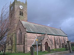
The earliest mention of a chapel in Blackrod was in 1338 when Dame Mabel de Bradshagh endowed a chantry priest to say divine service and mass in the chapel of St Catherine. [2] The present church, dedicated to St Katharine of Alexandria, is of Norman design though Elizabethan work can still be seen. The parish church was enlarged in 1776, galleries added in 1837, the roof renewed in 1894, the chancel rebuilt in 1905 and nave in 1911. During this time the spelling was changed to Catherine, and then again to the current Katharine. There are six bells in the west tower, cast in 1776, renewed in 1922, and the clock was illuminated in 1947.

A full refurbishment of the belfry installation was completed in 2015. [22]

St Katharines Church from Winterhill St Katharines from Winterhill.jpg
St Katharines Church from Winterhill

Transport

Blackrod is served by Blackrod railway station on the Manchester to Preston Line which opened in 1841 and where there was a branch line to Horwich. Mineral lines served the various collieries.

The main road through the township was the A6, Manchester to Preston road which now bypasses the town centre. The B5408 goes through the town. There are roads to Horwich and Aspull. The M61 motorway, part of the national motorway network between the M60/M62 (Manchester orbital motorway) and the M6 (Preston) was opened on 28 November 1969 by Fred Mulley, Minister of Transport.

See also

Related Research Articles

<span class="mw-page-title-main">Adlington, Lancashire</span> Village and civil parish in Lancashire, England

Adlington is a village and civil parish in the Borough of Chorley in Lancashire, England, near the West Pennine Moors. It is 3 miles south of Chorley. It became a separate parish in 1842 then grew into a township around the textile and coal mining industries until these closed in the 1960s. It had a population of 5,270 at the 2001 census, and risen to 6,010 at the 2011 census. The Leeds and Liverpool Canal runs through the village and is host to White Bear Marina which is the largest marina on the Leeds and Liverpool Canal.

<span class="mw-page-title-main">Leigh, Greater Manchester</span> Town in the Metropolitan Borough of Wigan

Leigh is a town in the Metropolitan Borough of Wigan, Greater Manchester, England, on low-lying land northwest of Chat Moss.

<span class="mw-page-title-main">Metropolitan Borough of Bolton</span> Borough of Greater Manchester, England

The Metropolitan Borough of Bolton is a metropolitan borough in Greater Manchester, England, named after its largest town, Bolton, but covering a larger area which includes Blackrod, Farnworth, Horwich, Kearsley, Westhoughton, and part of the West Pennine Moors. It had a population of 276,800 at the 2011 census, making it the fourth-most populous district in Greater Manchester.

<span class="mw-page-title-main">Westhoughton</span> Town in Greater Manchester, England

Westhoughton is a town and civil parish in the Metropolitan Borough of Bolton, Greater Manchester, England, 4 miles (6 km) southwest of Bolton, 5 miles (8 km) east of Wigan and 13 miles (21 km) northwest of Manchester.

<span class="mw-page-title-main">Hindley, Greater Manchester</span> Human settlement in England

Hindley is a town within the Metropolitan Borough of Wigan in Greater Manchester, England. It is three miles (4.8 km) east of Wigan and covers an area of 2,580 acres (1,044 ha). Within the boundaries of the historic county of Lancashire, Hindley borders the towns and villages of Ince-in-Makerfield, Aspull, Westhoughton, Atherton and Westleigh in the former borough of Leigh. In 2001, Hindley had a population of 23,457, increasing to 28,000 at the 2011 Census. It forms part of the wider Greater Manchester Urban Area.

<span class="mw-page-title-main">Horwich</span> Human settlement in England

Horwich is a town and civil parish in the Metropolitan Borough of Bolton, Greater Manchester, England, within the Historic County Boundaries of Lancashire. It is 5.3 miles (8.5 km) southeast of Chorley, 5.8 miles (9.3 km) northwest of Bolton and 15 miles (24 km) northwest of Manchester. It lies at the southern edge of the West Pennine Moors with the M61 motorway passing close to the south and west. At the 2011 Census, Horwich had a population of 20,067.

<span class="mw-page-title-main">Atherton, Greater Manchester</span> Town in Greater Manchester, England

Atherton is a town in the Metropolitan Borough of Wigan in Greater Manchester, England and historically part of Lancashire. The town, including Hindsford, Howe Bridge and Hag Fold, is 5 miles (8.0 km) south of Bolton, 7 miles (11.3 km) east of Wigan, and 10 miles (16.1 km) northwest of Manchester. From the 17th century, for about 300 years, Atherton was known as Chowbent, which was frequently shortened to Bent, the town's old nickname. During the Industrial Revolution, the town was a key part of the Manchester Coalfield.

<span class="mw-page-title-main">Pendlebury</span> Town in Greater Manchester, England

Pendlebury is a town in the City of Salford, Greater Manchester, England. The population at the 2011 Census was 13,069. It lies 4 miles (6 km) north-west of Manchester, 3 miles (5 km) north-west of Salford and 6 miles (10 km) south-east of Bolton.

<span class="mw-page-title-main">Haigh, Greater Manchester</span> Village in Greater Manchester, England

Haigh is a village and civil parish in the Metropolitan Borough of Wigan, Greater Manchester, England. Historically part of Lancashire, it is located next to the village of Aspull. The western boundary is the River Douglas, which separates the township from Wigan. To the north, a small brook running into the Douglas divides it from Blackrod. At the 2001 census it had a population of 594.

<span class="mw-page-title-main">Astley, Greater Manchester</span> Human settlement in England

Astley is a village in the Metropolitan Borough of Wigan, Greater Manchester, England. Within the boundaries of the historic county of Lancashire, it is crossed by the Bridgewater Canal and the A580 East Lancashire Road. Continuous with Tyldesley, it is between Wigan and Manchester, both 8 miles (13 km) away. Astley Mosley Common ward had a population of 11,270 at the 2011 Census.

<span class="mw-page-title-main">Kearsley</span> Town in Bolton, Greater Manchester, England

Kearsley is a town in the Metropolitan Borough of Bolton, Greater Manchester, England. The population at the 2011 census was 14,212. Within the Historic County of Lancashire, it lies 8 miles (13 km) northwest of Manchester, 5 miles (8 km) southwest of Bury and 3+34 miles (6 km) south of Bolton.

<span class="mw-page-title-main">Rivington</span> Village in Lancashire, England

Rivington is a village and civil parish of the Borough of Chorley, Lancashire, England, occupying 2,538 acres. It is about 6 miles (9.7 km) southeast of Chorley and about 8+12 miles (13.7 km) northwest of Bolton. Rivington is a rural area consisting primarily of agricultural grazing land, moorland, with hill summits including Rivington Pike and Winter Hill within the West Pennine Moors. The area has a thriving tourist industry centred around reservoirs created to serve Liverpool in the Victorian era and Lever Park created as a public park by William Lever at the turn of the 20th century, with two converted barns, a replica of Liverpool Castle and open countryside. Rivington and Blackrod High School is located here. Rivington and its village had a population of 109 at the 2011 Census.

<span class="mw-page-title-main">Walkden</span> Town in City of Salford, Greater Manchester, England

Walkden is a town in the City of Salford in Greater Manchester, England, six miles northwest of central Salford, and seven miles of Manchester.

Westhoughton was a parliamentary constituency in Lancashire, England. Centred on the former mining and cotton town of Westhoughton, it returned one Member of Parliament (MP) to the House of Commons of the Parliament of the United Kingdom.

<span class="mw-page-title-main">Blue Bus and Coach Services</span>

Blue Bus was a large independent bus company serving Greater Manchester, Lancashire and Merseyside.

<span class="mw-page-title-main">Rivington and Blackrod High School</span> Voluntary controlled comprehensive and sixth form school in England

Rivington and Blackrod High School in the North West region of England is a Leverhulme Trust multi-academy school alongside Harper Green School, it operates as a Church of England teaching environment with a sixth form school. The school is located at two sites, with the upper school situated on Rivington Lane in Rivington, Lancashire, and the lower school situated on Albert Street in Horwich, Greater Manchester.

<span class="mw-page-title-main">Rivington Church</span> Anglican parish church in Rivington, Lancashire, England

Rivington Church is an active Anglican parish church in Rivington, Lancashire, England. It is in the Deane deanery, the Bolton archdeanery and Diocese of Manchester. The church has been designated a Grade II listed building. The church has no patron saint and is not named after a saint or martyr. It has been variously called St Lawrence, St George, Holy Trinity, and St Catherine but its correct title is Rivington Church.

<span class="mw-page-title-main">Over Hulton</span> Human settlement in England

Over Hulton is a suburb of Westhoughton within the Metropolitan Borough of Bolton, in Greater Manchester, England. Historically part of Lancashire, it lies 3.5 miles (5.6 km) south west of Bolton.

Thomas Hampson was an English author and local historian.

References

  1. Mills, A.D. (2003), A Dictionary of British Place-Names, Oxford: Oxford University Press, ISBN   0-19-852758-6 (subscription required)
  2. 1 2 3 4 Farrer, William; Brownbill, J., eds. (1911), "Blackrod", A History of the County of Lancaster: Volume 5, British History Online, pp. 299–303, retrieved 25 November 2010
  3. Billington, W.D. (1982). From Affetside to Yarrow: Bolton place names and their history, Ross Anderson Publications ( ISBN   0-86360-003-4).
  4. 1 2 3 Lewis, Samuel, ed. (1848), "Blackrod", A Topographical Dictionary of England, British History Online, pp. 58–62, retrieved 25 November 2010
  5. Bolton.org.uk – Blackrod. URL accessed 4 May 2007.
  6. Collieries at work in 1869, Coal Mining History Resource Centre, retrieved 26 November 2010
  7. Scot Lane Colliery, Durham Mining Museum, retrieved 25 November 2010
  8. Blackrod Township Boundaries, GenUKI, retrieved 25 November 2010
  9. Workhouse, workhouses.org.uk, archived from the original on 5 June 2011, retrieved 25 November 2010
  10. Greater Manchester Gazetteer, Greater Manchester County Record Office, Places names – B, archived from the original on 18 July 2011, retrieved 2 May 2008
  11. Blackrod Town Council, Blackrod Town Council, archived from the original on 25 July 2011, retrieved 25 November 2010
  12. "Election Maps: Great Britain". Ordnance Survey. Retrieved 28 December 2021.
  13. "Red Moss citation sheet" (PDF), Natural England, retrieved 25 November 2010
  14. Red Moss lnr, Lancashire Wildlife Trust, archived from the original on 20 July 2011, retrieved 25 November 2010
  15. Tatton, Pauline. Local population statistics 1801–1986. Bolton Central Library Archives.
  16. "Administrative unit: Blackrod CP/Ch". Vision of Britain . Retrieved 20 March 2016.
  17. "Administrative unit: Blackrod UD". Vision of Britain . Retrieved 20 March 2016.
  18. "Area: Blackrod (Parish), Key Figures for 2001 Census: Key Statistics". Office for National Statistics . Retrieved 20 March 2016.
  19. "Area: Blackrod (Parish), Key Figures for 2011 Census: Key Statistics". Office for National Statistics . Retrieved 20 March 2016.
  20. Kay 1966 , pp. 116
  21. Scot Lane End CofE Primary School, Blackrod, www.education.gov.uk, retrieved 30 December 2015
  22. Thought for the Month – September 2015, St Katharine's Church, retrieved 30 December 2015

Bibliography