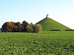
Hillock

Last updated

A hillock or knoll is a small hill, [1] usually separated from a larger group of hills such as a range. Hillocks are similar in their distribution and size to small mesas or buttes. This particular formation occurs often in Great Britain and China.[ clarification needed ] A similar type of landform in the Scandinavian countries goes by the name "kulle" or "bakke" (depending on the country) and is contrary to the above phenomena formed when glaciers polish down hard, crystalline bedrock of gneiss or granites, leaving a rounded rocky hillock with sparse vegetation. [2]

Contents

One of the most famous knolls is the one near John F. Kennedy's point of assassination, the grassy knoll, in Dealey Plaza of downtown Dallas, Texas. It is the source of many prominent conspiracy theories regarding the circumstances of his assassination.

A "blind knoll" is either hidden or not readily apparent to those driving vehicles. There are road signs that warn of this, advising drivers to slow down.

See also

Notes

  1. The Free Dictionary, "hillock" entry, retrieved December 18, 2007
  2. Gjessing, L. (1978). Norges landformer. Oslo: Universitetsforlaget. p. 207. ISBN   82-00-01772-9.


Related Research Articles

Sienna is an earth pigment containing iron oxide and manganese oxide. In its natural state, it is yellowish brown, and it is called raw sienna. When heated, it becomes a reddish brown, and it is called burnt sienna. It takes its name from the city-state of Siena, where it was produced during the Renaissance. Along with ochre and umber, it was one of the first pigments to be used by humans, and is found in many cave paintings. Since the Renaissance, it has been one of the brown pigments most widely used by artists.

Landforms are categorized by characteristic physical attributes such as their creating process, shape, elevation, slope, orientation, rock exposure, and soil type.

<span class="mw-page-title-main">Dealey Plaza</span> Dallas, Texas, U.S. historic place

Dealey Plaza is a city park in the West End Historic District of downtown Dallas, Texas. It is sometimes called the "birthplace of Dallas". It was also the location of the assassination of John F. Kennedy in 1963. Thirty minutes after the shooting, Kennedy was pronounced dead at Parkland Memorial Hospital. The Dealey Plaza Historic District was named a National Historic Landmark on the 30th anniversary of the assassination, to preserve Dealey Plaza, street rights-of-way, buildings, and structures by the plaza visible from the assassination site, that have been identified as witness locations or as possible locations for the assassin.

<span class="mw-page-title-main">Butte</span> Isolated hill with steep, often vertical sides and a small, relatively flat top

In geomorphology, a butte is an isolated hill with steep, often vertical sides and a small, relatively flat top; buttes are smaller landforms than mesas, plateaus, and tablelands. The word butte comes from the French word butte, meaning knoll ; its use is prevalent in the Western United States, including the southwest where mesa is used for the larger landform. Due to their distinctive shapes, buttes are frequently landmarks in plains and mountainous areas. To differentiate the two landforms, geographers use the rule of thumb that a mesa has a top that is wider than its height, while a butte has a top that is narrower than its height.

<span class="mw-page-title-main">Little Miss Muffet</span> English nursery rhyme

"Little Miss Muffet" is an English nursery rhyme of uncertain origin, first recorded in 1805. It has a Roud Folk Song Index number of 20605. The rhyme has for over a century attracted discussion as to the proper meaning of the word tuffet.

<span class="mw-page-title-main">Toboggan</span> Simple sled

A toboggan is a simple sled traditionally used by children. It is also a traditional form of transport used by the Innu and Cree of northern Canada.

<span class="mw-page-title-main">Sledgehammer</span> Heavy striking tool

A sledgehammer is a tool with a large, flat, often metal head, attached to a long handle. The long handle combined with a heavy head allows the sledgehammer to gather momentum during a swing and apply a large force compared to hammers designed to drive nails. Along with the mallet, it shares the ability to distribute force over a wide area. This is in contrast to other types of hammers, which concentrate force in a relatively small area.

In geography, knoll is another term for a knowe or hillock, a small, low, round natural hill or mound.

<span class="mw-page-title-main">Schiehallion</span> Mountain in central Scotland

Schiehallion is a prominent cone-shaped mountain in the Breadalbane region of the Scottish Highlands, in the county of Perthshire. It rises to 1,083 metres (3,553 ft) and is classed as a Munro. Schiehallion has a rich flora, interesting folklore and archaeology, and a unique place in scientific history for an 18th-century experiment in "weighing the Earth". It is near the centre of mainland Scotland. The mountain's popularity amongst walkers led to erosion on its footpath and extensive repairs were undertaken in 2001.

<span class="mw-page-title-main">Hummock</span> Small knoll or mound above ground

In geology, a hummock is a small knoll or mound above ground. They are typically less than 15 meters (50 ft) in height and tend to appear in groups or fields. Large landslide avalanches that typically occur in volcanic areas are responsible for formation of hummocks. From the initiation of the landslide to the final formation, hummocks can be characterized by their evolution, spatial distribution, and internal structure. As the movement of landslide begins, the extension faulting results in formation of hummocks with smaller ones at the front of the landslide and larger ones in the back. The size of the hummocks is dependent on their position in the initial mass. As this mass spreads, the hummocks further modify to break up or merge to form larger structures. It is difficult to make generalizations about hummocks because of the diversity in their morphology and sedimentology. An extremely irregular surface may be called hummocky.

<span class="mw-page-title-main">Hill</span> Landform that extends above the surrounding terrain

A hill is a landform that extends above the surrounding terrain. It often has a distinct summit, and is usually applied to peaks which are above elevation compared to the relative landmass, though not as prominent as mountains. Hill comes in the category of slope places.

Rubble is broken stone, of irregular size, shape and texture; undressed especially as a filling-in. Rubble naturally found in the soil is known also as 'brash'. Where present, it becomes more noticeable when the land is ploughed or worked.

<span class="mw-page-title-main">Madayi</span> Census Town in Kerala, India

Madayi. is a Census Town and Grama panchayat in Kannur district of Kerala state, India.

<span class="mw-page-title-main">Lion's Mound</span> War memorial in Braine-lAlleud, Wallonia, Belgium

The Lion's Mound is a large conical artificial hill in the municipality of Braine-l'Alleud, Walloon Brabant, Belgium. King William I of the Netherlands ordered its construction in 1820, and it was completed in 1826. It commemorates the spot on the battlefield of Waterloo where the king's elder son, Prince William of Orange, is presumed to have been wounded on 18 June 1815, as well as the Battle of Quatre Bras, which had been fought two days earlier.

A moot hill or mons placiti is a hill or mound historically used as an assembly or meeting place, as a moot hall is a meeting or assembly building, also traditionally to decide local issues. In early medieval Britain, such hills were used for "moots", meetings of local people to settle local business. Among other things, proclamations might be read; decisions might be taken; court cases might be settled at a moot. Although some moot hills were naturally occurring features or had been created long before as burial mounds, others were purpose-built.

<span class="mw-page-title-main">Tannerre-en-Puisaye</span> Commune in Bourgogne-Franche-Comté, France

Tannerre-en-Puisaye is a commune in the Yonne department, in Bourgogne-Franche-Comté, in north-central France, in the historical region of Puisaye.

<span class="mw-page-title-main">Moswetuset Hummock</span> United States historic place

Moswetuset Hummock is a Native American site and the original name of the tribe (Mosetuset) in the region named Massachusetts after them. The wooded hummock in Squantum, Massachusetts, is formally recognized as historic by descendants of the Ponkapoag people.

This glossary of geography terms is a list of definitions of terms and concepts used in geography and related fields, including Earth science, oceanography, cartography, and human geography, as well as those describing spatial dimension, topographical features, natural resources, and the collection, analysis, and visualization of geographic data. It is split across two articles:

<span class="mw-page-title-main">Wormy Hillock Henge</span> Historic site in Aberdeenshire, Scotland

Wormy Hillock Henge, also known as The Dragon's Grave, is a small henge in Aberdeenshire, Scotland. It is a Scheduled Ancient Monument located in the Clashindarroch Forest. It is a low, circular bank 16.5 metres (54 ft) in diameter which almost surrounds a 6-metre (20 ft) wide platform in the centre. There is one gap in the bank at the southeast end of the henge.

<span class="mw-page-title-main">Tel Michal</span>

Tel Michal is an archaeological site on Israel's central Mediterranean coast, near the modern city of Herzliya, about 6.5 kilometres (4.0 mi) north of the Yarkon River estuary and 4 kilometres (2.5 mi) south of Arsuf-Appolonia. Excavations have yielded remains from the Middle Bronze Age to the Early Arab period.