
The M60 motorway, Manchester Ring Motorway or Manchester Outer Ring Road is an orbital motorway in North West England. Built over a 40-year period, it passes through all of Greater Manchester's metropolitan boroughs except for Wigan and Bolton. Most of Manchester is encompassed within the motorway, except for the southernmost part of the city which is served by the M56.

The Astley Green Colliery Museum is a museum run by the Red Rose Steam Society in Astley near Tyldesley in Greater Manchester, England. Before becoming a museum, the site was a working colliery that produced coal from 1912 to 1970; it is now protected as a Scheduled Monument. The museum occupies a 15-acre (6 ha) site by the Bridgewater Canal which has the only surviving pit headgear and engine house on the Lancashire Coalfield.

Stalybridge and Hyde is a constituency in Greater Manchester that was created in 1918. The seat has been represented in the House of Commons of the Parliament of the United Kingdom by Jonathan Reynolds of the Labour and Co-operative Party since 2010. Reynolds currently serves as Secretary of State for Business and Trade under the government of Keir Starmer.

Horwich Parkway is a railway station serving the town of Horwich and suburb of Middlebrook in Greater Manchester, England. The station is 16+1⁄4 miles (26.2 km) north west of Manchester Piccadilly on the Manchester to Preston line. The station is close to Junction 6 of the M61 motorway. It has digital information displays.

Smithills Hall is a Grade I listed manor house, and a scheduled monument in Smithills, Bolton, Greater Manchester, England. It stands on the slopes of the West Pennine Moors above Bolton at a height of 500 feet (150 m), 3 miles (4.8 km) north west of the town centre. It occupies a defensive site near the Astley and Raveden Brooks. One of the oldest manor houses in North West England, its oldest parts, including the great hall, date from the 15th century and it has since been altered and extended, particularly the west wing. Parts of it were moated. The property is owned by Bolton Metropolitan Borough Council and open to the public.

The geography of Greater Manchester is dominated by one of the United Kingdom's largest metropolitan areas, and in this capacity the landlocked metropolitan county constitutes one of the most urbanised and densely populated areas of the country. There is a mix of high density urban areas, suburbs, semi-rural and rural locations in Greater Manchester, but overwhelmingly the land use in the county is urban.

There are 37 scheduled monuments in Greater Manchester, a metropolitan county in North West England. In the United Kingdom, a scheduled monument is a "nationally important" archaeological site or historic building that has been given protection against unauthorised change by being placed on a list by the Secretary of State for Digital Culture, Media and Sport; Historic England recommends sites for scheduling to the Secretary of State. Scheduled monuments are defined in the Ancient Monuments and Archaeological Areas Act 1979 and the National Heritage Act 1983. There are nearly 20,000 entries on the schedule, which is maintained by Historic England as part of the National Heritage List for England; more than one site can be included in a single entry. While a scheduled monument can also be recognised as a listed building, Historic England's aim is to set the most appropriate form of protection in place for the building or site. Applications to deschedule a site are administered Historic England, who will carry out an assessment and make a recommendation to the Secretary of State.
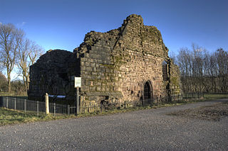
Radcliffe Tower is the only surviving part of a manor house in Radcliffe, Greater Manchester, England. It is a Grade I listed building and a Scheduled Monument. The house was rebuilt in 1403 by James de Radcliffe, who was lord of the manor of Radcliffe, and consisted of a stone-built hall and one or two towers, probably built with ashlar blocks. De Radcliffe was given a royal licence to fortify the site including adding crenellations and battlements.

Brown Low is a bowl barrow most likely dating to the Bronze Age. An earth and stone mound survives east of Marple, Greater Manchester. It is listed as a Scheduled Ancient Monument. The mound was partially excavated by the Rev William Marriott in 1809, who discovered fragments of burnt stones and cremated bones, as well as a preserved acorn. Marriott also describes the finding of a funerary urn in an adjacent barrow during an unauthorised excavation. Brown Low is on private land, just east of a public footpath running off Sandy Lane.
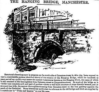
Hanging Bridge is a medieval arched bridge spanning Hanging Ditch, a watercourse which connected the rivers Irk and Irwell in Manchester, England. It was built in 1421, replacing an earlier bridge at the same location. Eventually completely obscured by buildings over time, the bridge was rediscovered in the 1880s and the structure is now partially exposed. The bridge is listed as a Scheduled Ancient Monument.
Castlesteads may refer to one of the following:
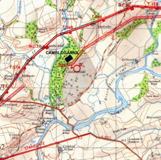
Camboglanna was a Roman fort. It was the twelfth fort on Hadrian's Wall counting from the east, between Banna (Birdoswald) almost 7 miles (11 km) to the east and Uxelodunum (Stanwix), 9 miles to the west. It was on a high bluff commanding the Cambeck Valley. It guarded an important approach to the Wall and also watched the east bank of the Cambeck against raiders from the Bewcastle area. The site was drastically levelled in 1791 when the gardens of Castlesteads House were laid over it. The name "Camboglanna" is believed to mean "Crook Bank", or "Bent Valley" because it overlooks a bend in the river Irthing; the name is Brythonic, made of cambo- "curved, bent, crooked" and glanna "steep bank, stream/river side, valley with a stream".

Helsby hill fort is an Iron Age hillfort overlooking the village of Helsby in Cheshire, northwest England. Helsby Hill has steep cliffs on the northern and western sides, providing a natural semicircular defence. Double rampart earthworks extend to the south and east to provide protection to those flanks. Two additional banks have been discovered enclosing a rock ledge on the cliff to the north side. Excavations last century revealed a wall composed of sand and rubble, revetted with stone to the back and front. The hill has a summit of 141 m AOD, and is a prominent landmark rising above the Cheshire Plain, with fine views overlooking the Mersey Estuary and into Wales. Much of the hill is owned and managed by the National Trust. The surrounding areas are well wooded to the southwest, northwest and northeast with farmland to the southeast. The hill fort is protected as a Scheduled Ancient Monument.
Burton Point is an Iron Age promontory fort located 1 mile (1.6 km) to the southeast of the village of Burton, in the Wirral Peninsula, Cheshire, England. The site, which overlooks the estuary of the River Dee, consists of tree-covered earthworks in the form of a bank and ditch. The area to the north of which has been quarried for its underlying sandstone. The fort is a scheduled monument. To the south of the fort is a burial site that was excavated in 1878, revealing the remains of between 50 and 60 burials. It is not known whether these are of an early Christian date, or if they are the remains of a local shipwreck in 1637.
New Hall moated site is a scheduled monument in Tyldesley, Greater Manchester, England. It includes a moat and an island platform on which a modern house has been built. The island was the site of a medieval building. The moat measures between 20 and 30 metres across and is widest at the south west corner where the water soaks away to join a stream. The moat was revetted on the south side but the stonework is destroyed and is bridged on the same side by a modern stone bridge which replaced a timber structure. The rectangular island, measuring 60 metres by 40 metres, encloses an area of 0.25 hectares and is 0.4 metres above the surrounding land. Archaeological evidence of the medieval buildings will be present on the island and the moat will retain other environmental evidence. A ruined post-medieval farmhouse occupied a third of the island in 1983. The present modern buildings are excluded from the scheduling, although the ground beneath them is part of the schedule.

Bispham Hall is a Grade II* listed Elizabethan country house in Billinge, now part of the Metropolitan Borough of Wigan, Greater Manchester, England.
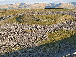
Castle Folds or Castlesteads was a Romano-British walled settlement on Great Asby Scar – an area of limestone pavement in the parish of Asby, Cumbria, England. In medieval times, it was used as a shieling – a temporary summer shelter. It is now in ruins but is protected as a scheduled monument.

Combs Moss is a plateau-topped hill between Chapel-en-le-Frith and Buxton in Derbyshire, in the Peak District. The summit, Combs Head, is 503 metres (1,650 ft) above sea level. At its northern tip is a prehistoric promontory fort called Castle Naze.
