Taunton Deane was a local government district with borough status in Somerset, England. It merged with West Somerset to form Somerset West and Taunton on 1 April 2019. Its council was based in Taunton. The district was formed on 1 April 1974, under the Local Government Act 1972, by a merger of the Municipal Borough of Taunton, Wellington Urban District, Taunton Rural District, and Wellington Rural District. Taunton Deane was granted borough status in 1975, enabling the mayoralty of Taunton to be continued, when other districts did not have mayors. [1] The district was given the name of an alternate form of the Taunton Deane Hundred.
A scheduled monument is a nationally important archaeological site or monument which is given legal protection by being placed on a list (or "schedule") by the Secretary of State for Digital, Culture, Media and Sport; English Heritage takes the leading role in identifying such sites. The legislation governing this is the Ancient Monuments and Archaeological Areas Act 1979. The term "monument" can apply to the whole range of archaeological sites, and they are not always visible above ground. Such sites have to have been deliberately constructed by human activity. They range from prehistoric standing stones and burial sites, through Roman remains and Medieval structures such as castles and monasteries, to later structures such as industrial sites and buildings constructed for the World Wars or the Cold War. [2]
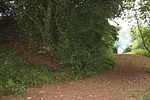
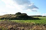
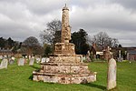
There are 33 scheduled monuments in Taunton Deane. Many of them are Neolithic through to the Bronze and Iron Ages such as bowl barrows, cairns along with hill forts such as Norton Camp. [3] Castle Neroche was an Iron Age hill fort which was reused as a Norman motte-and-bailey castle. [4] Burrow Mump shows evidence of Roman use but is better known as a Norman motte-and-bailey castle, [5] and later church. [6] It was presented, in 1946, by Major Alexander Gould Barrett, to the National Trust to serve as a memorial to the 11,281 [7] Somerset men who lost their lives during the first and second world wars. [8]
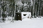
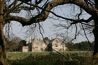
The Medieval period is represented by several churchyard crosses. The defensive walls and part of Taunton Castle, which has Anglo-Saxon origins and was expanded during the Medieval and Tudor eras, is included. [9] [10] More recent sites include Poundisford Park, Buckland Priory, Bradford Bridge and a duck decoy from the 17th century. Some of the sites such as Balt Moor Wall are of uncertain date; however the most recent are air traffic control buildings, pillboxes and fighter pens from RAF Culmhead, situated at Churchstanton on the Blackdown Hills. [11] [12] The monuments are listed below using the titles given in the English Heritage data sheets.
The Blackdown Hills National Landscape is a National Landscape along the Somerset-Devon border in south-western England, which were designated in 1991 as an Area of Outstanding Natural Beauty (AONB). In November 2023, it has become 'Blackdown Hills National Landscape' The area encompasses a set of hills of the same name.
Burrowbridge is a village and civil parish in Somerset, England, situated on the River Parrett and the A361 road on the edge of the Somerset Levels. It is located 5 miles (8.0 km) southeast of Bridgwater, and has a population of 508.
Cothelstone is a village and civil parish in Somerset, England, situated in the Quantock Hills six miles north of Taunton. The parish, which includes the hamlet of Toulton, has a population of 111.
Otterford is a village and civil parish in Somerset, England. It is situated on the Blackdown Hills, 7 miles (11.3 km) south of Taunton. The village has a population of 356.
West Bagborough is a village and civil parish in Somerset, England, about 5 miles (8.0 km) north of Taunton. In 2011, the village had a population of 358.
Burrow Mump is a hill and historic site overlooking Southlake Moor in the village of Burrowbridge within the English county of Somerset. It is a scheduled monument, with a never completed church on top of the hill a Grade II listed building.
Taunton Deane is a local government district with borough status in the English county of Somerset. In the United Kingdom, the term listed building refers to a building or other structure officially designated as being of special architectural, historical or cultural significance; Grade I structures are those considered to be "buildings of exceptional interest". Listing was begun by a provision in the Town and Country Planning Act 1947. Once listed, severe restrictions are imposed on the modifications allowed to a building's structure or its fittings. In England, the authority for listing under the Planning Act 1990 rests with Historic England, a non-departmental public body sponsored by the Department for Digital, Culture, Media and Sport; local authorities have a responsibility to regulate and enforce the planning regulations.
Poundisford Park north of Pitminster, Somerset, England is an English country house that typifies progressive housebuilding on the part of the West Country gentry in the mid-16th century. The main house was built for William Hill around 1550 and has been designated as a Grade I listed building.
The Yeovil Scarplands are a natural region in southern England in the counties of Somerset and Dorset.
Taunton Deane is a local government district with borough status in the English county of Somerset. In the United Kingdom, the term listed building refers to a building or other structure officially designated as being of special architectural, historical or cultural significance; Grade II* structures are those considered to be "particularly significant buildings of more than local interest". Listing was begun by a provision in the Town and Country Planning Act 1947. Once listed, severe restrictions are imposed on the modifications allowed to a building's structure or its fittings. In England, the authority for listing under the Planning Act 1990 rests with Historic England, a non-departmental public body sponsored by the Department for Digital, Culture, Media and Sport; local authorities have a responsibility to regulate and enforce the planning regulations.
There are over 670 scheduled monuments in the ceremonial county of Somerset in South West England. The county consists of a non-metropolitan county, administered by Somerset County Council, which is divided into five districts, and two unitary authorities. The districts of Somerset are West Somerset, South Somerset, Taunton Deane, Mendip and Sedgemoor. The two administratively independent unitary authorities, which were established on 1 April 1996 following the breakup of the county of Avon, are North Somerset and Bath and North East Somerset. These unitary authorities include areas that were once part of Somerset before the creation of Avon in 1974.
Robin Hood's Butts are a group of nine Bronze Age barrows near Otterford on the Blackdown Hills in Somerset, England. They have been scheduled as ancient monuments.