Cothelstone | |
---|---|
Vicarage | |
Summit of Cothelstone Hill | |
Location within Somerset | |
Population | 111 (2011) [1] |
OS grid reference | ST185315 |
Unitary authority | |
Ceremonial county | |
Region | |
Country | England |
Sovereign state | United Kingdom |
Post town | TAUNTON |
Postcode district | TA4 |
Dialling code | 01823 |
Police | Avon and Somerset |
Fire | Devon and Somerset |
Ambulance | South Western |
UK Parliament | |
Cothelstone is a village and civil parish in Somerset, England, situated in the Quantock Hills six miles north of Taunton. The parish, which includes the hamlet of Toulton, has a population of 111. [1]
The view from Cothelstone with a telescope on a fine day is said to include 14 counties and 150 churches. [2]
There are several bowl barrows on Cothelstone Hill. [3] [4] [5] [6]
The manor of Cothelstone was given to the Stawell family after the Norman conquest of England in 1066. [2] The parish of Cothelstone was part of the Taunton Deane Hundred. [7]
During the English Civil War, Sir John Stawell of Cothelstone had raised a small force at his own expense to defend the King. Taunton fell to parliamentary troops and was held by Robert Blake who attacked Stawell at Bishops Lydeard and imprisoned him. After the restoration, Charles II conferred the title of Baron Stawell on Sir John's son, Ralph. [2]
The parish council has responsibility for local issues, including setting an annual precept (local rate) to cover the council's operating costs and producing annual accounts for public scrutiny. The parish council evaluates local planning applications and works with the local police, district council officers, and neighbourhood watch groups on matters of crime, security, and traffic. The parish council's role also includes initiating projects for the maintenance and repair of parish facilities, as well as consulting with the district council on the maintenance, repair, and improvement of highways, drainage, footpaths, public transport, and street cleaning. Conservation matters (including trees and listed buildings) and environmental issues are also the responsibility of the council.
For local government purposes, since 1 April 2023, the village comes under the unitary authority of Somerset Council. Prior to this, it was part of the non-metropolitan district of Somerset West and Taunton (formed on 1 April 2019) and, before this, the district of Taunton Deane (established under the Local Government Act 1972). From 1894-1974, for local government purposes, Cothelstone was part of Taunton Rural District. [8]
It is also part of the Taunton Deane county constituency represented in the House of Commons of the Parliament of the United Kingdom. It elects one Member of Parliament (MP) by the first past the post system of election, and was part of the South West England constituency of the European Parliament prior to Britain leaving the European Union in January 2020, which elected seven MEPs using the d'Hondt method of party-list proportional representation.
Cothelstone Manor was built in the mid 16th century, largely demolished by the parliamentary troops in 1646 and rebuilt by E.J. Esdaile in 1855–56. [9] The 16th-century gatehouse [10] and gazebo [11] and 17th-century Banqueting Hall have survived. [12]
The nearby St Agnes' Well is a Grade II* Well house dating from the Medieval period and restored in the nineteenth century. It is constructed of coursed red sandstone masonry with corbel roof. Its water is accessed via an arched doorway behind which is a large volume of clear shallow water. The water is also piped off for farm use. It has a varied folklore, noted as being a healing well, a wishing well of considerable power, an aid to fertility, and virgins used divinations to 'discover' their future husbands on the eve of St Agnes's feast day. It is currently undergoing further restoration. [13] [14] [15]
At the summit of Cothelstone Hill is a grove of beech trees known as the Seven Sisters. Originally planted in the 18th century by Mary Hill, Lady Hillsborough, they form a well-known and prominent landmark visible from large areas of Somerset and South Wales. [16] [17]
The red sandstone Church of St Thomas of Canterbury dates from the 12th century and was largely restored in 1864. It includes memorials to the Stawell family including: Sir Matthew de Stawell, died 1379, and his wife Eleanor, and John Stawell, died 1603. The church has been designated by English Heritage as a Grade I listed building. [18]
The Quantock Hills west of Bridgwater in Somerset, England, consist of heathland, oak woodlands, ancient parklands and agricultural land. They were England's first Area of Outstanding Natural Beauty, designated in 1956.
Combe Florey is a village and civil parish in Somerset, England, situated 6 miles (9.7 km) northwest of Taunton, on the West Somerset Railway. The village has a population of 261. The parish includes the hamlet of Eastcombe which is a linear settlement along the A358 Taunton-Wiliton Road.
Ashbrittle is a village and civil parish in Somerset, England, situated nine miles west of Taunton and close to the River Tone and the route of the Grand Western Canal. The village has a population of 225.
Bishop's Hull is a village and civil parish in Somerset, England, in the western suburbs of Taunton. It includes the areas of Rumwell, Rumwell Park, Roughmoor and Longaller and is close to the River Tone. The parish, which includes the hamlet of Netherclay, has a population of 2,975 in total.
Cheddon Fitzpaine is a village and civil parish in Somerset, England, situated on the Quantock Hills 2 miles (3.2 km) north of Taunton. The village is situated near the Bristol and Exeter Railway, the Bridgwater and Taunton Canal, and the River Tone and has a population of 1,929.
Durston is a village and civil parish in Somerset, England, situated on the A361 road 5 miles (8.0 km) north east of Taunton and 6 miles (9.7 km) south of Bridgwater. The parish lies on undulating ground between the lowest slopes of the Quantock Hills and the valley of the River Tone at the Curry and Hay Moors. The parish has a population of 136.
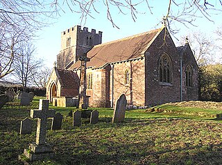
Kingston St Mary is a village and parish in Somerset, England, situated at the southern end of the Quantock Hills 4 miles (6.4 km) north of Taunton. The village has a population of 921.
Otterford is a village and civil parish in Somerset, England. It is situated on the Blackdown Hills, 7 miles (11.3 km) south of Taunton. The village has a population of 356.
Pitminster is a village and civil parish in Somerset, England, situated 4 miles (6.4 km) south of Taunton. The parish has a population of 956. The parish also includes the villages of Angersleigh, Blagdon Hill and Staplehay. The village of Blagdon is now officially known as Blagdon Hill to distinguish it from Blagdon in North Somerset. Hillside hamlets in the parish comprise Feltham and Woodram, those on the lower plain in the north are Sellicks Green which is contiguous with Blagdon Hill, Duddlestone and Poundisford.
Thornfalcon is a village and civil parish in Somerset, England, situated 4 miles (6.4 km) east of Taunton. The village has a population of 119. The parish includes the hamlet of Ash. The name comes from Thorn, and the personal name Fagun which was the Norman surname of Sir Gilbert of Thorn, whose family were lords of the manor until the 14th century.
Tolland is a village and civil parish in Somerset, England, situated 9 miles (14.5 km) north west of Taunton, between the Brendon Hills and Quantock Hills. The parish has a population of 81.
West Bagborough is a village and civil parish in Somerset, England, about 5 miles (8.0 km) north of Taunton. In 2011, the village had a population of 358.
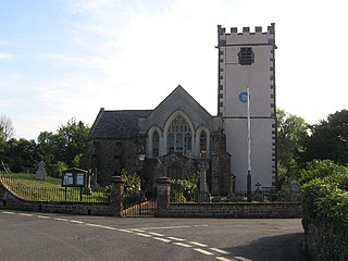
Wiveliscombe is a town and civil parish in Somerset, England, situated 9 miles (14 km) west of Taunton. The town has a population of 2,893. The Square, fronted by several listed structures, held the former market. The parish includes the nearby hamlet of Maundown.
Bicknoller is a village and civil parish on the western slopes of the Quantock Hills in the English county of Somerset.
Holford is a village and civil parish in West Somerset within the Quantock Hills Area of Outstanding Natural Beauty. It is located about 10 miles (16 km) west of Bridgwater and 6 miles (10 km) east of Williton, with a population of 392. The village is on the Quantock Greenway and Coleridge Way footpaths. The parish includes the village of Dodington.
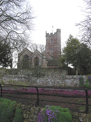
The romanesque red sandstone Church of St Thomas of Canterbury in Cothelstone, Somerset, England dates from the 12th century and has been designated as a Grade I listed building.
The Anglican Church of St Lawrence in Lydeard St Lawrence, Somerset, England dates from 1350 and has been designated as a Grade I listed building.
Cothelstone Manor in Cothelstone, Somerset, England was built in the mid-16th century, largely demolished by the parliamentary troops in 1646 and rebuilt by E.J. Esdaile in 1855–56.
Taunton Deane was a local government district with borough status in Somerset, England. It merged with West Somerset to form Somerset West and Taunton on 1 April 2019. Its council was based in Taunton. The district was formed on 1 April 1974, under the Local Government Act 1972, by a merger of the Municipal Borough of Taunton, Wellington Urban District, Taunton Rural District, and Wellington Rural District. Taunton Deane was granted borough status in 1975, enabling the mayoralty of Taunton to be continued, when other districts did not have mayors. The district was given the name of an alternate form of the Taunton Deane Hundred.
There are over 670 scheduled monuments in the ceremonial county of Somerset in South West England. The county consists of a non-metropolitan county, administered by Somerset Council. The two administratively independent unitary authorities, which were established on 1 April 1996 following the breakup of the county of Avon, are North Somerset and Bath and North East Somerset. These unitary authorities include areas that were once part of Somerset before the creation of Avon in 1974.
Media related to Cothelstone at Wikimedia Commons