Burrow Mump

Last updated

Burrow Mump and St Michael's Church Burrow Mump and St Micheal.jpeg
Burrow Mump and St Michael's Church

Burrow Mump is a hill and historic site overlooking Southlake Moor in the village of Burrowbridge within the English county of Somerset. It is a scheduled monument, with a never completed church on top of the hill a Grade II listed building.

Contents

The hill stands at a strategic location overlooking the point where the River Tone and the old course of the River Cary join the River Parrett. Although there is some evidence of Roman visitation, the first fortification of the site was the construction of a Norman motte. It has been called King Alfred's Fort, however there is no proof of use by Alfred the Great. A medieval church was built on the hill in the 15th century. The current ruined church on top of the hill was built in 1793. The land and ruin were donated to the National Trust in 1946 as a war memorial.

Geology

Burrow Mump from the village of Burrowbridge Burrow Mump - geograph.org.uk - 1628142.jpg
Burrow Mump from the village of Burrowbridge

The hill is 24 metres (79 ft) high, [1] and stands at a strategic point where the River Tone and the old course of the River Cary join the River Parrett, above the surrounding low lying land of the Somerset Levels. [2] It is made of Triassic sandstone capped by Keuper marl ascribed to the Mercia Mudstone Group. [2] [3]

Early use

Burrow Mump is also known as St Michael's Borough or Tutteyate. [4] Both words 'burrow' and 'mump' mean hill. [5]

Archaeological surveys have shown some Roman material including a piece of pottery [6] and coins found nearby which, possibly linked to its situation at a river junction, may indicate its use for trade. [7] [8] [9] Square pits, one of which may have been a well and post holes from the Middle Ages have been identified during excavations, these may have been from an adulterine castle. [10] [11] [12] It is likely that it was a Norman motte with a terraced track that spirals around the hill to reach it. [13] The plateau at the top is 45 metres (150 ft) by 25 metres (80 ft) and along with the scarped top of the slope formed the motte, which may have been formed during The Anarchy between 1135 and 1153. [11] The site has been called King Alfred's Fort, but there is no evidence of it being a fort [12] or having any link with Alfred the Great, [14] apart from its ownership by the nearby Athelney Abbey which he established and was linked to Burrow Mump by a causeway. [15] [16] [17] It may have served as a natural outwork to the defended royal island of Athelney at the end of the 9th century. [18]

Excavations have shown evidence of a 12th-century masonry building on the top of the hill, which may be from the probable adulterine castle. [6] The side of the mound may have been terraced for agricultural use due to much of the surrounding land flooded on a regular basis during the medieval period. [15]

The ruins of St Michael's Church on top of Burrow Mump Burrow Mump.JPG
The ruins of St Michael's Church on top of Burrow Mump

The first recorded writing mentioning this site is from William Worcester in about 1480 when he referred to it as Myghell-borough. A medieval church dedicated to St Michael, belonging to the Athelney Abbey, [19] dates from at least the mid-15th century. This formed a sanctuary for royalist troops in 1642 and 1645 during the English Civil War, [20] and a detachment of the king's army occupied it in 1685 during the course of the Monmouth Rebellion. [14]

18th century rebuilding

In 1793, the church was rebuilt with a west tower, 3-bay nave and south porch, in squared and coursed lias with red brick and Hamstone dressings. [11] The attempt at total rebuilding ended in failure to collect enough money, despite donations from William Pitt the Younger and Admiral Hood, [13] and a church for the community was built instead at the foot of the hill (Burrowbridge) in 1838. [11] In the mid 20th century the ruin on Burrow Mump underwent some repairs to the north west corner. [11]

The ruined church is one of the churches dedicated to St. Michael that falls on a ley line proposed by John Michell of the pseudoscientific Earth Mysteries Movement. Other connected St. Michaels on the ley line include churches built at Othery and Glastonbury Tor. [21] . However, Michell’s ley line is drawn as a straight line on a map across the counties of Wiltshire, Somerset, Devon and Cornwall linking his sites, and does not take into account the curvature of the Earth. Churches built on hills were also frequently dedicated to St Michael, and it is just a coincidence that a small scattering of churches dedicated to St Michael are found roughly near to the route of his line.

Memorial

Memorial plaque Plaque on St Michaels Chapel on Burrow Mump (geograph 2834284).jpg
Memorial plaque

The site of 3.573 hectares (8.83 acres) including the hill and ruined church were presented, in 1946, by Major Alexander Gould Barrett, [22] to the National Trust and serve as a memorial to the 11,281 [23] Somerset men who lost their lives during the First and Second World Wars. [24] The National Trust was taken to court for nuisance after soil from Burrow Mump slipped onto a neighbouring farmer's land. [25] The ruin was classified as a Grade II listed building in 1963. [26] It has been a Scheduled monument since 1949. [11]

Related Research Articles

<span class="mw-page-title-main">River Parrett</span> River in Dorset and Somerset, England

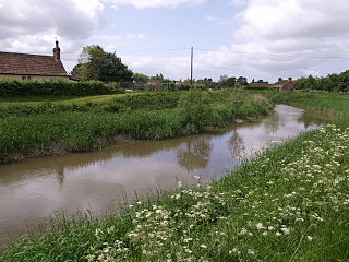
The River Parrett flows through the counties of Dorset and Somerset in South West England, from its source in the Thorney Mills springs in the hills around Chedington in Dorset. Flowing northwest through Somerset and the Somerset Levels to its mouth at Burnham-on-Sea, into the Bridgwater Bay nature reserve on the Bristol Channel, the Parrett and its tributaries drain an area of 660 square miles (1,700 km2) – about 50 per cent of Somerset's land area, with a population of 300,000.

<span class="mw-page-title-main">Somerset Levels</span> Coastal plain and wetland area of Somerset, England

The Somerset Levels are a coastal plain and wetland area of Somerset, England, running south from the Mendips to the Blackdown Hills.

<span class="mw-page-title-main">River Tone</span> River in Somerset, England

The River Tone is a river in the English county of Somerset. The river is about 33 kilometres (21 mi) long. Its source is at Beverton Pond near Huish Champflower in the Brendon Hills, and is dammed at Clatworthy Reservoir. The reservoir outfall continues through Taunton and Curry and Hay Moors, which are designated as a Site of Special Scientific Interest. Finally, it flows into the River Parrett at Burrowbridge.

<span class="mw-page-title-main">Martock</span> Human settlement in England

Martock is a large village and civil parish in Somerset, England, situated on the edge of the Somerset Levels 7 miles (11.3 km) north west of Yeovil in the South Somerset district. The parish includes Hurst, approximately one mile south of the village, and Bower Hinton, which is located at the western end of the village and bounded by Hurst and the A303. Martock has a population of 4,766 and was historically a market town.

<span class="mw-page-title-main">Langport</span> Human settlement in England

Langport is a small town and civil parish in Somerset, England, 5 miles (8 km) west of Somerton. The parish, which covers only part of the town, has a population of 3,578. Langport is contiguous with Huish Episcopi, a separate parish that includes much of the town's outskirts.

<span class="mw-page-title-main">Burrowbridge</span> Human settlement in England

Burrowbridge is a village and civil parish in Somerset, England, situated on the River Parrett and the A361 road in the Somerset West and Taunton district, on the edge of the Somerset Levels. It is located 5 miles (8.0 km) southeast of Bridgwater, and has a population of 508.

<span class="mw-page-title-main">North Curry</span> Human settlement in England

North Curry is a village and civil parish in Somerset, England, 5 miles (8.0 km) east of Taunton in the Somerset West and Taunton district. The parish, which includes several hamlets, had a population of 1,640 in 2011.

<span class="mw-page-title-main">Kingsbury Episcopi</span> Human settlement in England

Kingsbury Episcopi is a village and civil parish on the River Parrett in Somerset, England, situated 9 miles (14.5 km) north west of Yeovil in the South Somerset district. The village has a population of 1,307. The parish includes the villages of West Lambrook, East Lambrook and Thorney.

<span class="mw-page-title-main">Westonzoyland Pumping Station Museum</span> English industrial heritage museum

The Westonzoyland Pumping Station Museum of Steam Power and Land Drainage is a small industrial heritage museum dedicated to steam powered machinery at Westonzoyland in the English county of Somerset. It is a Grade II* listed building.

<span class="mw-page-title-main">Lyng, Somerset</span> Human settlement in England

Lyng is a civil parish in Somerset, England, comprising the villages of West Lyng and East Lyng and the hamlet of Bankland.

<span class="mw-page-title-main">Othery</span> Human settlement in England

The parish and village of Othery, established in 1515, sits on a detached extension of Sowy island on the Somerset Levels. It is 7 miles (11 km) east of Bridgwater and 4 miles (6 km) north-west of Langport. It borders the hamlets and villages of Pathe, Burrowbridge, Middlezoy, Westonzoyland and Aller, which it meets at Beer Wall. The border with Burrowbridge was defined in 1985, reducing Othery to 553 ha. Many of these borders are defined by ditches and walls created and rearranged, from the 13th century onwards, to drain and channel the waters of the River Cary and the River Parrett as they flooded the low-lying levels on their way to the Bristol Channel.

<span class="mw-page-title-main">South Petherton</span> Village and civil parish in Somerset, England

South Petherton is a large village and civil parish in the South Somerset district of Somerset, England, located 5 miles (8 km) east of Ilminster and 5 miles (8 km) north of Crewkerne. The parish had a population of 3,737 in 2021 and includes the smaller village of Over Stratton and the hamlets of Compton Durville, Drayton, Wigborough and Yeabridge. The River Parrett forms the eastern boundary of the parish. The village is approximately 2 miles (3 km) from East Lambrook, Martock and Lopen.

<span class="mw-page-title-main">Athelney Abbey</span>

Athelney Abbey, established in the county of Somerset, England, was founded by King Alfred in 888, as a religious house for monks of the Order of St. Benedict. It was dedicated to "Our Blessed Saviour, St. Peter, St. Paul, and St. Egelwine".

<span class="mw-page-title-main">St Michael's Church, Othery</span> Building in Othery, England

The Church of St Michael in Othery, Somerset, England dates back to the 12th century. It has been designated by English Heritage as a Grade I listed building. It is on the Heritage at Risk Register due to the state of the high level stonework on the tower.

<span class="mw-page-title-main">St Gregory's Church, Stoke St Gregory</span> Church in Stoke St Gregory, England

The Church of St Gregory Stoke St Gregory, is a Church of England parish church in Somerset, England. Its parish is part of the Athelney Benefice, along with the parishes of St Michael, Burrowbridge, St Bartholomew, Lyng and SS Peter and Paul, North Curry.

<span class="mw-page-title-main">Montacute Castle</span>

Montacute Castle was a castle built on a hill overlooking the village of Montacute, Somerset, England.

<span class="mw-page-title-main">Grade II* listed buildings in Sedgemoor</span>

Sedgemoor is a local government district in the English county of Somerset. In the United Kingdom, the term listed building refers to a building or other structure officially designated as being of special architectural, historical or cultural significance; Grade II* structures are those considered to be "particularly significant buildings of more than local interest". Listing was begun by a provision in the Town and Country Planning Act 1947. Once listed, severe restrictions are imposed on the modifications allowed to a building's structure or its fittings. In England, the authority for listing under the Planning Act 1990 rests with Historic England, a non-departmental public body sponsored by the Department for Digital, Culture, Media and Sport; local authorities have a responsibility to regulate and enforce the planning regulations.

<span class="mw-page-title-main">Scheduled monuments in Taunton Deane</span>

Taunton Deane was a local government district with borough status in Somerset, England. It merged with West Somerset to form Somerset West and Taunton on 1 April 2019. Its council was based in Taunton. The district was formed on 1 April 1974, under the Local Government Act 1972, by a merger of the Municipal Borough of Taunton, Wellington Urban District, Taunton Rural District, and Wellington Rural District. Taunton Deane was granted borough status in 1975, enabling the mayoralty of Taunton to be continued, when other districts did not have mayors. The district was given the name of an alternate form of the Taunton Deane Hundred.

<span class="mw-page-title-main">Scheduled monuments in Somerset</span> Nationally important sites in Somerset, England

There are over 670 scheduled monuments in the ceremonial county of Somerset in South West England. The county consists of a non-metropolitan county, administered by Somerset Council. The two administratively independent unitary authorities, which were established on 1 April 1996 following the breakup of the county of Avon, are North Somerset and Bath and North East Somerset. These unitary authorities include areas that were once part of Somerset before the creation of Avon in 1974.

References

  1. "Burrow Mump". European Garden Heritage Network. Archived from the original on 17 December 2010. Retrieved 5 October 2010.
  2. 1 2 Hawkins 1982, p. 16.
  3. "Geology of Britain viewer". British Geological Survey. Retrieved 22 January 2015.
  4. "Burrow Mump". The Gatehouse. Retrieved 5 October 2010.
  5. Philip Coppens. "Glastonbury: England's oldest sacred landscape?" . Retrieved 12 November 2010.
  6. 1 2 "The Burrow Mump Excavations" . Taunton Courier, and Western Advertiser. 22 April 1939. Retrieved 22 January 2015 via British Newspaper Archive.
  7. Jenkins, Palden. "Burrowbridge Mump". Palden Jenkins. Retrieved 21 May 2015.
  8. "Burrow Mump, Burrowbridge". Somerset Historic Environment Record. Somerset County Council. Retrieved 21 May 2015.
  9. "Roman coin hoard, Burrow Wall Rhyne, Burrowbridge". Somerset Historic Environment Record. Somerset County Ouncil. Retrieved 21 May 2015.
  10. "Burrow Mump, Burrowbridge". Gatehouse. Retrieved 21 May 2015.
  11. 1 2 3 4 5 6 Historic England. "Burrow Mump: a motte castle, later chapel and associated earthworks (1011823)". National Heritage List for England . Retrieved 21 May 2015.
  12. 1 2 Historic England. "Burrow Mump (192181)". Research records (formerly PastScape). Retrieved 3 March 2014.
  13. 1 2 "Burrow Mump, Burrowbridge". Somerset Historic Environment Record. Somerset County Council. Retrieved 4 October 2010.
  14. 1 2 Adkins 1992, pp. 32–33.
  15. 1 2 "Report for Aerial Survey Component Block 2: Somerset Levels" (PDF). The Aggregate Landscape of Somerset: Predicting the Archaeological Resource. English Heritage. pp. 24–25. Retrieved 3 March 2014.
  16. "Burrow Mump". European Garden Heritage Network. Retrieved 21 May 2015.
  17. Williams & Williams 1992, p. 44.
  18. Interpretive signs at the foot of Burrow Mump & brochure/map (Map). National Trust, Levels and Moors Partnership.
  19. Hawkins 1982, pp. 121–122.
  20. Quinn 2008, pp. 22–23.
  21. "The St. Michael's Ley, England". Ancient-Wisdom. Archived from the original on 22 September 2010. Retrieved 5 October 2010.
  22. "Acquisitions Up to December 2011". National Trust. p. 6. Archived from the original on 14 July 2014. Retrieved 22 January 2015.
  23. Dunning 1983, p. 101.
  24. Leete-Hodge 1985, p. 82.
  25. Fea, Vivennne (1981). "Means Test Liability: The Subjective Standard of Care in Nuisance". Otago Law Review. 417.
  26. Historic England. "Remains of Church on Burrow Mump (1344609)". National Heritage List for England . Retrieved 5 April 2015.

Bibliography

51°04′06″N2°55′14″W / 51.06840°N 2.92049°W / 51.06840; -2.92049