Othery

Last updated • 4 min readFrom Wikipedia, The Free Encyclopedia

Othery
Otherychurch.JPG
The Church of St Michael
Somerset UK location map.svg
Red pog.svg
Othery
Location within Somerset
Population642 (2011) [1]
OS grid reference ST3823
Unitary authority
Ceremonial county
Region
Country England
Sovereign state United Kingdom
Post town BRIDGWATER
Postcode district TA7
Dialling code 01823
Police Avon and Somerset
Fire Devon and Somerset
Ambulance South Western
UK Parliament
List of places
UK
England
Somerset
51°05′N2°53′W / 51.08°N 2.88°W / 51.08; -2.88

The parish and village of Othery, established in 1515, sits on a detached extension of Sowy island on the Somerset Levels. It is 7 miles (11 km) east of Bridgwater and 4 miles (6 km) north-west of Langport. It borders the hamlets and villages of Pathe, Burrowbridge, Middlezoy, Westonzoyland and Aller, which it meets at Beer Wall. The border with Burrowbridge was defined in 1985, reducing Othery to 553 ha (1,366 acres). Many of these borders are defined by ditches and walls created and rearranged, from the 13th century onwards, to drain and channel the waters of the River Cary and the River Parrett as they flooded the low-lying levels on their way to the Bristol Channel.

Contents

History

The name means "Other-island". The "island" of Othery rising above the Levels is a mixed sedimentary and alluvial deposit: marl, Mercia mudstone, sand and gravel ("Burtle Beds"), peat, and deposits from the basin of the River Parrett. The moors on the shallowest deposits are just 13 feet (4 m) above sea level, with the highest hill, on the southwest side of Othery, standing 82 feet (25 m) above sea level.

The parish of Othery was part of the Whitley Hundred. [2]

Othery once had three pubs, but currently has just one, The London Inn. It had a village shop (closed), a post office (closed), a bakery (Maisey's, also now closed,) and a primary school. There is also a very active village hall. Othery borders two Sites of Special Scientific Interest, both designated in 1985: Southlake Moor and Sedgemoor, to the north of Beer Wall. [3]

Governance

The parish council has responsibility for local issues, including setting an annual precept (local rate) to cover the council’s operating costs and producing annual accounts for public scrutiny. The parish council evaluates local planning applications and works with the local police, district council officers, and neighbourhood watch groups on matters of crime, security, and traffic. The parish council's role also includes initiating projects for the maintenance and repair of parish facilities, as well as consulting with the district council on the maintenance, repair, and improvement of highways, drainage, footpaths, public transport, and street cleaning. Conservation matters (including trees and listed buildings) and environmental issues are also the responsibility of the council. The chairman of the Parish Council until 2019 was Councillor Mervyn Winslade MBE who stood down at the May elections. At the first meeting of the newly elected council, Councillor Anthony Bostock was elected Chairman. He remained in post until his resignation in May 2021. Since May 2021 Councillor Andrew Tizzard has been Chairman.

For local government purposes, since 1 April 2023, the village comes under the unitary authority of Somerset Council. Prior to this, it was part of the non-metropolitan district of Sedgemoor, which was formed on 1 April 1974 under the Local Government Act 1972, having previously been part of Bridgwater Rural District. [4]

It is also part of the Bridgwater county constituency represented in the House of Commons of the Parliament of the United Kingdom. It elects one Member of Parliament (MP) by the first past the post system of election, and was part of the South West England constituency of the European Parliament prior to Britain leaving the European Union in January 2020, which elected seven MEPs using the d'Hondt method of party-list proportional representation.

Religious sites

Othery was a chapelry of Sowy parish with its own chaplain from the 13th century. In 1515, when Sowy was divided, Othery became a separate parish with its own parish church and vicar. The church of St Michael was dedicated before 1203. [5] The church, perpendicular in style, was remodelled in the 15th century, and partly rebuilt after 1844. Its typical Somerset tower was restored in 1849 and in 1853, when pinnacles and niches were built; sculptures of heads and angels were added in the following years. There are five bells in the tower; the oldest dates to the 1650s and was made by Robert Austen. The other bells date from between 1692 and 1815. Roundels of medieval glass, originally from Glastonbury Abbey and depicting the heads of three doctors of the church, have been preserved. Stained glass by Hardman, Bell, and Holland of Warwick was installed in the 1850s in the chancel, vestry, and north transept. The church houses a memorial to the three Chard brothers, who included Colonel John Chard, V.C. (d. 1897), who led the defence of Rorke's Drift, South Africa, and whose father lived at Pathe. It has been designated by English Heritage as a Grade I listed building. [6]

The church registers go back to 1560, but the oldest register appears to be a rather poor late 17th-century copy of the original, "crudely arranged in alphabetical order of Christian names and with a gap from K-Q." [3]

The Othery Cope, found under the mediaeval pulpit at the time of the Victorian renovations, is an extremely rare 16th-century ecclesiastical robe, restored and now housed at the Glastonbury Abbey Museum.

Othery church is one of the churches dedicated to St Michael that falls on a ley line proposed by John Michell. Other connected St Michaels on the ley line include churches built at Burrow Mump and Glastonbury Tor.

The first Vicar of Othery Parish was John Colmer (1515–1522). [5]

Reverend Andrea Harwood is current Priest in Charge. The Churchwardens as of 2021 are Mr Mervyn Winslade MBE and Mrs Maragret Harris, who are supported by the Deputy Churchwardens who are Mr Anthony Betty and Mrs Anita Winslade.

Related Research Articles

<span class="mw-page-title-main">River Parrett</span> River in Dorset and Somerset, England

The River Parrett flows through the counties of Dorset and Somerset in South West England, from its source in the Thorney Mills springs in the hills around Chedington in Dorset. Flowing northwest through Somerset and the Somerset Levels to its mouth at Burnham-on-Sea, into the Bridgwater Bay nature reserve on the Bristol Channel, the Parrett and its tributaries drain an area of 660 square miles (1,700 km2) – about 50 per cent of Somerset's land area, with a population of 300,000.

<span class="mw-page-title-main">Somerset Levels</span> Coastal plain and wetland area of Somerset, England

The Somerset Levels are a coastal plain and wetland area of Somerset, England, running south from the Mendips to the Blackdown Hills.

<span class="mw-page-title-main">Puriton</span> Village in Somerset, England

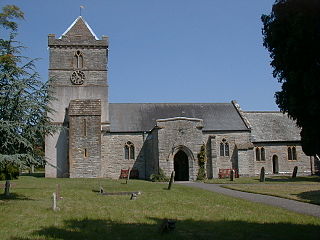
Puriton is a village and parish at the westerly end of the Polden Hills, in Somerset, England. The parish has a population of 1,968. The local parish church is dedicated to St Michael and All Angels. A chapel on Woolavington Road was converted to a private house some 20 years ago. The parish includes the hamlets of Dunball and Down End.

<span class="mw-page-title-main">Ashcott</span> Human settlement in England

Ashcott is a small village and civil parish located in the Sedgemoor area of Somerset in the south-west of England. The village has a population of 1,186. The parish includes the hamlets of Ashcott Corner, Berhill, Buscott, Nythe and Pedwell.

<span class="mw-page-title-main">Burrowbridge</span> Human settlement in England

Burrowbridge is a village and civil parish in Somerset, England, situated on the River Parrett and the A361 road on the edge of the Somerset Levels. It is located 5 miles (8.0 km) southeast of Bridgwater, and has a population of 508.

<span class="mw-page-title-main">Bawdrip</span> Human settlement in England

Bawdrip is a village and civil parish in Somerset, England. The village is on the south side of the Polden Hills about 4 miles (6.4 km) north-east of Bridgwater. At the 2011 census the parish had a population of 506. The parish includes the hamlets of Bradney, Horsey and Knowle.

<span class="mw-page-title-main">Westonzoyland</span> Human settlement in England

Westonzoyland is a village and civil parish in Somerset, England. It is situated on the Somerset Levels, 4 miles (6.4 km) south east of Bridgwater.

<span class="mw-page-title-main">Huntspill</span> Village in Somerset, England

Huntspill is a village and former civil parish on the Huntspill Level in Somerset, England. It lies on the A38 road, 1.5 miles (2.4 km) south of Highbridge. The village is the principal settlement in the civil parish of West Huntspill. In 2019 it had an estimated population of 1102.

<span class="mw-page-title-main">Lyng, Somerset</span> Human settlement in England

Lyng is a civil parish in Somerset, England, comprising the villages of West Lyng and East Lyng and the hamlet of Bankland.

<span class="mw-page-title-main">Woolavington</span> Human settlement in England

Woolavington is a village and civil parish on the Somerset Levels in the English county of Somerset. It is 5.2 miles (8.4 km) north east of Bridgwater, 7.2 miles (11.6 km) south east of Burnham on Sea and 11.9 miles (19.2 km) west of Glastonbury. At the 2021 census it had a population of 2,325.

<span class="mw-page-title-main">Burrow Mump</span> Hill in the United Kingdom

Burrow Mump is a hill and historic site overlooking Southlake Moor in the village of Burrowbridge within the English county of Somerset. It is a scheduled monument, with a never completed church on top of the hill a Grade II listed building.

<span class="mw-page-title-main">Greinton</span> Human settlement in England

Greinton is a village and civil parish in Somerset, England, situated on the Somerset Levels and Moors at the foot of the Polden Hills, 9 kilometres (5.6 mi) west southwest of Glastonbury and 7 miles (11 km) east of Bridgwater.

<span class="mw-page-title-main">Cossington, Somerset</span> Village in Somerset, England

Cossington is a village and civil parish close to Woolavington and 5 miles (8 km) north of Bridgwater, in Somerset, England. The village lies on the north side of the Polden Hills. Its population in 2021 was 640.

<span class="mw-page-title-main">Chilton Trinity</span> Human settlement in England

Chilton Trinity is a village and civil parish on the River Parrett, 2 miles (3 km) north of Bridgwater in Somerset, England.

<span class="mw-page-title-main">Middlezoy</span> Human settlement in England

Middlezoy is a village and civil parish on the Somerset Levels in Somerset, England. Situated between the two other villages of Westonzoyland and Othery and is about six miles from the town of Bridgwater which is on the tidal river Parret.

<span class="mw-page-title-main">Moorlinch</span> Human settlement in England

Moorlinch is a village and civil parish where the Polden Hills meet the Somerset Levels in Somerset, England.

<span class="mw-page-title-main">St Michael's Church, Othery</span>

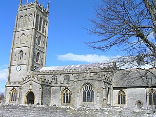
The Church of St Michael in Othery, Somerset, England dates back to the 12th century. It has been designated by English Heritage as a Grade I listed building. It is on the Heritage at Risk Register due to the state of the high level stonework on the tower.

<span class="mw-page-title-main">Winter flooding of 2013–14 on the Somerset Levels</span> Flooding in Somerset, England

From December 2013 onwards the Somerset Levels suffered severe flooding as part of the wider 2013–2014 Atlantic winter storms in Europe and subsequent 2013–2014 United Kingdom winter floods. The Somerset Levels, or the Somerset Levels and Moors as they are less commonly but more correctly known, is a coastal plain and wetland area of central Somerset, in South West England, running south from the Mendip Hills to the Blackdown Hills.

References

  1. "Statistics for Wards, LSOAs and Parishes — SUMMARY Profiles" (Excel). Somerset Intelligence. Retrieved 4 January 2014.
  2. "Somerset Hundreds". GENUKI. Retrieved 22 October 2011.
  3. 1 2 Dunning, Robert (2004). A History of the County of Somerset.
  4. "Bridgwater RD". A vision of Britain Through Time. University of Portsmouth. Retrieved 4 January 2014.
  5. 1 2 "Othery | British History Online".
  6. Historic England. "Church of St Michael (1060090)". National Heritage List for England . Retrieved 6 January 2008.