Brean

Last updated

Brean
Brean Sands, Somerset, England, from Brean Down arp.jpg
Brean Sands and village from Brean Down
Somerset UK location map.svg
Red pog.svg
Brean
Location within Somerset
Population635 (2011) [1]
OS grid reference ST296560
Unitary authority
Ceremonial county
Region
Country England
Sovereign state United Kingdom
Post town BURNHAM-ON-SEA
Postcode district TA8
Dialling code 01278
Police Avon and Somerset
Fire Devon and Somerset
Ambulance South Western
UK Parliament
List of places
UK
England
Somerset
51°18′00″N3°00′40″W / 51.300°N 3.011°W / 51.300; -3.011

Brean is a village and civil parish between Weston-super-Mare and Burnham-on-Sea in Somerset, England. The name is derived from "Bryn"; Brythonic and Modern Welsh for a hill and it has a population of 635.

Contents

Close to the village is Brean Down, a promontory standing 320 feet (98 m) high and extending 1.5 miles (2.4 km) into the Bristol Channel, on which stands Brean Down Fort, marking the end of Weston Bay.

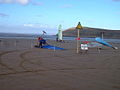
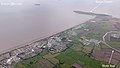
The village is on a strip of land between the sea and the River Axe. It is the home of Brean Leisure Park, a tropical bird garden, [2] other tourist attractions and several caravan parks. The sandy beach has been used for land sailing since 1970. [3] Sometimes, Brean can also be linked with the nearby village, Berrow so the villages can also be called Berrow & Brean.

History

Brean was part of the hundred of Bempstone. [4] During the Bristol Channel floods of 1607 the village was flooded, with seven of its nine houses being destroyed and 26 inhabitants drowned. [5]

Windmill House, on South Road, was one of the terminuses for the PTAT-1 transatlantic communications cable from Manasquan, New Jersey, United States. [6] It was constructed in 1989 by Mercury Communications and closed in 2004. [6]

Governance

The parish council has responsibility for local issues, including setting an annual precept (local rate) to cover the council's operating costs and producing annual accounts for public scrutiny. The parish council evaluates local planning applications and works with the local police, district council officers, and neighbourhood watch groups on matters of crime, security, and traffic. The parish council's role also includes initiating projects for the maintenance and repair of parish facilities, as well as consulting with the district council on the maintenance, repair, and improvement of highways, drainage, footpaths, public transport, and street cleaning. Conservation matters (including trees and listed buildings) and environmental issues are also the responsibility of the council.

For local government purposes, since 1 April 2023, the village comes under the unitary authority of Somerset Council. Prior to this, it was part of the non-metropolitan district of Sedgemoor, which was formed on 1 April 1974 under the Local Government Act 1972, having previously been part of Axbridge Rural District. [7]

It is also part of the Wells county constituency represented in the House of Commons of the Parliament of the United Kingdom. It elects one Member of Parliament (MP) by the first past the post system of election, and was part of the South West England constituency of the European Parliament prior to Britain leaving the European Union in January 2020, which elected seven MEPs using the d'Hondt method of party-list proportional representation.

Religious sites

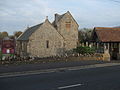
The Church of St Bridget dates from the 13th century, but the fabric is predominantly from the 15th century and was extensively rebuilt around 1882. It is designated by English Heritage as a Grade II* listed building. [8] The dedication to St Bridget of Ireland, Abbess of Kildare, who died in 525, is an indication of a Celtic Christian settlement.[ citation needed ]

Related Research Articles

<span class="mw-page-title-main">Burnham-on-Sea</span> Town in Somerset, England

Burnham-on-Sea is a seaside town in Somerset, England, at the mouth of the River Parrett, upon Bridgwater Bay. Burnham was a small fishing village until the late 18th century when it began to grow because of its popularity as a seaside resort.

<span class="mw-page-title-main">Kingston Seymour</span> Human settlement in England

Kingston Seymour is a small village and civil parish with royal status in Somerset, England. It is situated within the unitary authority of North Somerset, between Clevedon and Weston-super-Mare on the North Somerset Levels. The parish has a population of 388.

<span class="mw-page-title-main">Kewstoke</span> Human settlement in England

Kewstoke is a civil parish and village in Somerset, England, within the unitary authority of North Somerset, located next to the strip of coast called Sand Bay. Its population in the 2011 census was 1,690.

<span class="mw-page-title-main">Badgworth</span> Human settlement in England

Badgworth is a village and civil parish in Somerset, England, 2 miles (3.2 km) south west of Axbridge. According to the 2011 census it had a population of 525.

<span class="mw-page-title-main">Berrow, Somerset</span> Human settlement in England

Berrow is a small residential coastal village and holiday area, a civil parish in Somerset, England, situated in between Burnham-on-Sea and Brean.

<span class="mw-page-title-main">Bleadon</span> Human settlement in England

Bleadon is a village and civil parish in Somerset, England. It is about 4 miles (6.4 km) south of Weston-super-Mare and, according to the 2021 census, has a population of 1,149.

<span class="mw-page-title-main">Shipham</span> Human settlement in England

Shipham is a village and civil parish in Somerset, England. It is on the western edge of the Mendip Hills near the A38, approximately 15 miles (24 km) south of Bristol. The parish includes the village of Rowberrow and the hamlet of Star. The parish population, according to the 2011 census, is 1,087.

<span class="mw-page-title-main">Brockley, Somerset</span> Human settlement in England

Brockley is a village and civil parish in Somerset, England. The parish is within the unitary authority of North Somerset, about 3 miles (4.8 km) south of Nailsea, and includes the village of Chelvey. According to the 2011 census it had a population of 277.

<span class="mw-page-title-main">Brent Knoll (village)</span> Human settlement in England

Brent Knoll, formerly known as South Brent, is a village and civil parish in Somerset, England, which lies on the southern edge of Brent Knoll – a hill with a height of 137 metres (450 ft) that dominates the low surrounding landscape of the Somerset Levels.

<span class="mw-page-title-main">Locking, Somerset</span> Human settlement in England

Locking is a village and civil parish in Somerset, England. It is a predominantly quiet residential area of North Somerset, 3.5 miles (5.6 km) south east of the town of Weston-super-Mare.

<span class="mw-page-title-main">Burrington, Somerset</span> Human settlement in England

Burrington is a small village and civil parish in Somerset, England. It is situated in the unitary authority of North Somerset, 5 miles (8.0 km) north east of Axbridge and about 10 miles (16 km) east of Weston-super-Mare. The parish includes the hamlets of Bourne and Rickford and has a population of 464.

<span class="mw-page-title-main">Compton Bishop</span> Village and civil parish in England

Compton Bishop is a small village and civil parish, at the western end of the Mendip Hills in the English county of Somerset. It is located close to the historic town of Axbridge. Along with the village of Cross and the hamlets of Rackley and Webbington it forms the parish of Compton Bishop and Cross.

<span class="mw-page-title-main">Weare, Somerset</span> Human settlement in England

Weare is a village and civil parish in Somerset, England, on the River Axe, south of the Mendip Hills. Other settlements in the parish are the village of Lower Weare, the hamlets of Alston Sutton, Brinscombe, and Sparrow Hill, and part of the hamlet of Stone Allerton.

<span class="mw-page-title-main">Chapel Allerton, Somerset</span> Human settlement in England

Chapel Allerton is a village and civil parish, south of Cheddar in the English county of Somerset. The parish includes the hamlets of Ashton and Stone Allerton.

<span class="mw-page-title-main">Butcombe</span> Human settlement in England

Butcombe is a village and civil parish in Somerset, England. The village is situated just north of Blagdon Lake, in North Somerset. The parish has a population of 218 and mainly consists of family-owned farmland. It no longer has any amenities apart from a telephone kiosk and a letter box.

<span class="mw-page-title-main">Hutton, Somerset</span> Human settlement in England

Hutton is a village and civil parish in Somerset, England. The parish, which has a population of 2,582, is within the unitary authority of North Somerset and located on the western edge of the Mendip Hills, close to Weston-super-Mare.

<span class="mw-page-title-main">Puxton</span> Village in Somerset, England

Puxton is a village and civil parish, 5 miles (8.0 km) north west of Axbridge in the unitary authority of North Somerset within the ceremonial county of Somerset, England.

<span class="mw-page-title-main">St. Georges, North Somerset</span> Human settlement in England

St. Georges is a civil parish and village in the unitary authority of North Somerset, England. Its population in the 2011 census was 3,379.

<span class="mw-page-title-main">Lympsham</span> Human settlement in England

Lympsham is a village and civil parish six miles west of Axbridge and six miles south-east of Weston-super-Mare, close to the River Axe in Somerset, England. The parish includes the hamlet of Wick where Wick Farmhouse dates from the mid 18th century.

<span class="mw-page-title-main">St Bridget's Church, Brean</span> Church in Brean, England

St Bridget's Church, Brean is the Church of England parish church of the village of Brean in Somerset, England.

References

  1. "Civil Parish population 2011" . Retrieved 24 October 2015.
  2. "Brean Down Tropical Bird Garden" . Retrieved 31 January 2008.
  3. "Brean Land Yacht Club".
  4. "Bempstone Hundred". A Vision of Britain Through Time. Retrieved 21 October 2021.
  5. "1607 Flood in the Bristol Channel - Was it a UK tsunami?". 2015. Archived from the original on 4 March 2016. Retrieved 14 June 2016.
  6. 1 2 Sedgemore District Council - Planning Application 06/88/00020
  7. "Axbridge RD". A vision of Britain Through Time. University of Portsmouth. Retrieved 4 January 2014.
  8. Historic England. "Church of St Bridget (1262963)". National Heritage List for England . Retrieved 31 January 2008.