
The Bristol Channel is a major inlet in the island of Great Britain, separating South Wales from Devon and Somerset in South West England. It extends from the lower estuary of the River Severn to the North Atlantic Ocean. It takes its name from the English city of Bristol, and is over 30 miles (50 km) wide at its western limit.
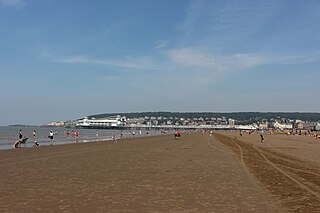
Weston-super-Mare, also known as Weston, is a seaside town in Somerset, England. It is part of the unitary authority of North Somerset. It lies by the Bristol Channel 18 miles (29 km) south west of Bristol between Worlebury Hill and Bleadon Hill. It includes the suburbs of Milton, Oldmixon, West Wick, Worlebury, Uphill and Worle. Its population at the 2011 census was 76,143. Since 1983, Weston has been twinned with Hildesheim in Germany.
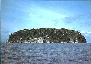
Steep Holm is an English island lying in the Bristol Channel. The island covers 48.87 acres (19.78 ha) at high tide, expanding to 63.26 acres (25.60 ha) at mean low water. At its highest point it is 78 metres (256 ft) above mean sea level. It lies within the historic county of Somerset and administratively forms part of North Somerset. Between 1 April 1974 and 1 April 1996 it was administered as part of Avon. Nearby is Flat Holm island, part of Wales.

Brean Down Fort was built 60 feet (18 m) above sea level on the headland at Brean Down, 9 miles (14 km) south of Weston-super-Mare, Somerset, England.

Brean Down is a promontory off the coast of Somerset, England, standing 318 feet (97 m) high and extending 1.5 miles (2 km) into the Bristol Channel at the eastern end of Bridgwater Bay between Weston-super-Mare and Burnham-on-Sea.

The Severn Estuary in Great Britain is the confluence of the River Severn, the River Wye, the River Usk, the River Avon, and other smaller rivers. Its high tidal range, approximately 50 feet (15 m), means that it has been at the centre of discussions in the UK regarding renewable energy.

Sand Bay is a strip of coast in North Somerset bordered to the south by Worlebury Hill and to the north by Middle Hope and Sand Point. It lies 2 miles (3.2 km) north of the seaside resort of Weston-super-Mare, and across the Bristol Channel from South Wales. It is adjacent to the village of Kewstoke.

Somerset is a rural county in the southwest of England, covering 4,171 square kilometres (1,610 sq mi). It is bounded on the north-west by the Bristol Channel, on the north by Bristol and Gloucestershire, on the north-east by Wiltshire, on the south-east by Dorset, and on the south west and west by Devon. It has broad central plains with several ranges of low hills. The landscape divides into four main geological sections from the Silurian through the Devonian and Carboniferous to the Permian which influence the landscape, together with water-related features.

Worlebury Hill is the name given to an upland area lying between the flatlands of Weston-super-Mare and the Kewstoke area of North Somerset, England. Worlebury Hill's rises from sea level to its highest point of 109 metres (358 ft), and the western end of the hill forms a peninsula, jutting out into the Bristol Channel, between Weston Bay and Sand Bay. A toll road follows the coast around the hill from Sand Bay in the north to the now derelict Birnbeck Pier in the west, although tolls are not currently collected on the road. Worlebury Golf Club is situated on the Hill and the area is known for being one of the wealthiest areas in the county of Somerset.

The Grand Pier is a pleasure pier in Weston-super-Mare, North Somerset, situated on the Bristol Channel approximately 18 miles (29 km) southwest of Bristol. It opened in 1904 and has been Listed Grade II since 1983. It is 366 metres (1,201 ft) long.

Birnbeck Pier, also known as the 'Old Pier', is a pier situated on the Bristol Channel in Weston-super-Mare, North Somerset, England, approximately 18 miles (29 km) south-west of Bristol. It is the only pier in the country which links the mainland to an island, linking to Birnbeck Island, a 1.2 hectares rocky island just to the west of Worlebury Hill. The grade II* listed pier was designed by Eugenius Birch and opened in 1867. The gothic toll house and pierhead buildings were designed by local architect Hans Price. The pier has been closed to the public since 1994 and is now on the Buildings at Risk Register.

Hans Price (1835–1912) was the architect responsible for much of the development of Weston-super-Mare, in North Somerset, England, during the Victorian era.

Uphill is a village in the civil parish of Weston-super-Mare in North Somerset, England, at the southern edge of the town, on the Bristol Channel coast.
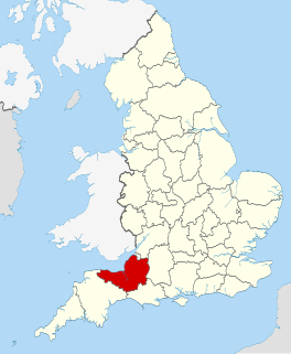
The county of Somerset is in South West England, bordered by the Bristol Channel and the counties of Bristol and Gloucestershire to the north, and Wiltshire to the east, Dorset to the south, and Devon to the west. The climate, influenced by its proximity to the Atlantic Ocean and the prevailing westerly winds, tends to be mild, damp and windy.

The Old Church of St Nicholas at Uphill, Somerset, England, dates from around 1080, and was built on the site of previous places of worship. It stands on a cliff top overlooking Brean Down and the mouth of the River Axe.
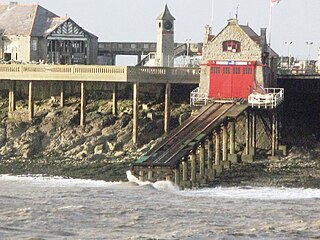
Weston-super-Mare Lifeboat Station is a lifeboat station at Weston-super-Mare in Somerset, England. For more than 100 years it was situated on Birnbeck Island but is now in a temporary building at Knightstone Harbour until a new lifeboat station can be built nearby. It is operated by the Royal National Lifeboat Institution (RNLI). The first lifeboat was stationed in the town in 1882, and since 1969 it has only operated inshore lifeboats (ILBs), currently a B-class and a smaller D-class (IB1).
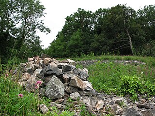
Worlebury Camp is the site of an Iron Age hillfort on Worlebury Hill, north of Weston-super-Mare in Somerset, England. The fort was well defended with a numerous walls, embankments and ditches around the site. Several large triangular platforms have been uncovered around the sides of the fort, lower down on the hillside. Nearly one hundred storage pits of various sizes were cut into the bedrock, and many of these had human remains, coins, and other artefacts in them. During the 19th and 20th centuries the fort suffered damage and was threatened with complete destruction on multiple occasions. Now, the site is a designated Scheduled monument. it falls within the Weston Woods Local Nature Reserve which was declared to Natural England by North Somerset Council in 2005.

The Weston-super-Mare Tramways were the electric street tramways of the seaside resort of Weston-super-Mare in Somerset, England. It operated a fleet of up to 16 standard gauge single- and double-deck tramcars on routes totalling 2.92 miles (4.70 km) to Birnbeck Pier, The Sanatorium and Locking Road. It opened in 1902 and was replaced by bus services in 1937.

Open top buses in Weston-super-Mare, Somerset, England, were introduced in 1950 and have run along the sea front every summer since. The initial operator was Bristol Tramways and this company's successors continued to provide services until 2013. The route from Weston-super-Mare railway station to Sand Bay is operated by First West of England. From time-to-time open top buses have also provided scenic tours in and around the town.

Sand Point in Somerset, England, is the peninsula stretching out from Middle Hope, an 84.1-hectare (208-acre) biological and geological Site of Special Scientific Interest. It lies to the north of the village of Kewstoke, and the stretch of coastline called Sand Bay north of the town of Weston-super-Mare. On a clear day it commands views over Flat Holm, of the Bristol Channel, South Wales, Clevedon, the Second Severn Crossing and the Severn Bridge. A line drawn between Sand Point and Lavernock Point in South Wales marks the lower limit of the Severn Estuary and the start of the Bristol Channel.
