The district was formed in 1974 as the Woodspring district of the county of Avon. Avon was abolished in 1996, when the district was renamed North Somerset and its council took on county-level functions from the abolished county council.
The district was created on 1 April 1974 under the Local Government Act 1972, covering four former districts and part of a fifth, which were all abolished at the same time:[4]
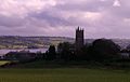
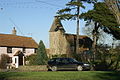
Woodspring Priory, which gave its name to the district as created in 1974.
The whole area had been part of Somerset prior to the 1974 reforms, but was transferred to the new county of Avon. The new district was named Woodspring after Woodspring Priory, an isolated medieval church near the coast in the parish of Kewstoke, north of Weston-super-Mare.[5]
Following the Banham Review, the county of Avon was abolished in 1996, with the area being divided into unitary authorities responsible for both district and county-level functions. Woodspring became one of the unitary authorities, and the government gave the district the new name "North West Somerset" as part of the reforms.[6] The area was also transferred back to Somerset for the ceremonial purposes of lieutenancy and shrievalty.[7]
In July 1995 the council resolved to change the name to "North Somerset" with effect from when the reforms came into effect on 1 April 1996. Some years later the government identified that the council's decision to rename in 1995 may not have been technically valid, and so in 2005 the council passed another resolution formally changing the name to put the matter beyond doubt.[8][9]
North Somerset Council provides both county-level and district-level services. The whole area is also covered by civil parishes, which form a second tier of local government.[10]
North Somerset's economy is traditionally based on agriculture, including sheep raised for wool on the Mendip Hills and dairy farming in the valleys. This is celebrated at the annual North Somerset Show. During the Georgian era tourism became a significant economic sector in the coastal towns, most notably Weston-super-Mare which grew from a small village to a large resort town. Though tourism declined in the mid to late-20th century, in common with most British coastal resorts, this sector of the economy has stabilised.
In the 19th century the major port city of Bristol found that modern ships had outgrown the narrow river approach and the Port of Bristol company began seeking locations for new docks on the coast. The first of these was Portishead Dock, which handled coal from South Wales, though this too has seen shipping outgrow its facilities. The newer Royal Portbury Dock is noted for the large volume of car imports.
This is a chart of trend of regional gross value added of North and North East Somerset and South Gloucestershire at current basic prices (pp.240–253) by Office for National Statistics with figures in millions of British Pounds Sterling. [15]
^1 Components may not sum to totals due to rounding ^2 includes hunting and forestry ^3 includes energy and construction ^4 includes financial intermediation services indirectly measured
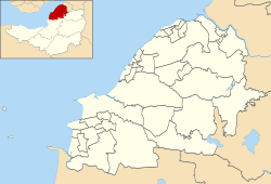
North Somerset covers an area of around 145 square miles (380km2) and has a resident population of 193,000 (1.4% BME) living in 85,000 households.[18]
The population of North Somerset has doubled since the 1950s and is predicted to rise by 6,184 or 3.0% to 2011 and by 17% to 2026. Whilst the proportion of people in North Somerset who are under 45 is lower than the national average, population growth is predicted to be strongest in the 2034 age group. Conversely North Somerset has a 4.2% higher percentage of older people (60+ female, 65+ male) than the rest of England and Wales. This disparity increases with age with the percentage of the population over 75 years almost 30% higher than the national average, resulting in a relatively aged population.[19]
In 2001 there were 134,132 people of working age living in North Somerset and 91,767 were in employment; an economic activity rate of 68.4%. This is very close to the economic activity rate of the West of England sub-region which was 68.8% in the 2001 census.[18]
The 2001 census stated that 1.38% of North Somerset residents identified themselves as belonging to a visible ethnic group and a further 1.27% identified themselves as 'white other'.[20]
As of 2023[update], North Somerset Council is associated with 72 primary schools and 18 secondary schools.[23][24] There are also four independent (private) schools in the area.[25]
This page is based on this Wikipedia article Text is available under the CC BY-SA 4.0 license; additional terms may apply. Images, videos and audio are available under their respective licenses.