Portbury

Last updated

Portbury
Portbury church.jpg
Somerset UK location map.svg
Red pog.svg
Portbury
Location within Somerset
Population827 (2011) [1]
OS grid reference ST502748
Unitary authority
Ceremonial county
Region
Country England
Sovereign state United Kingdom
Post town BRISTOL
Postcode district BS20
Dialling code 01275
Police Avon and Somerset
Fire Avon
Ambulance South Western
UK Parliament
List of places
UK
England
Somerset
51°28′12″N2°42′59″W / 51.4699°N 2.7163°W / 51.4699; -2.7163

Portbury is a village and civil parish in Somerset, England, within the unitary authority of North Somerset. The parish includes the hamlet Sheepway, which is situated on moorland at the northern edge of the Gordano valley, between the Gordano services on the M5 motorway and Portishead, near the Royal Portbury Dock. The parish has a population of 827. [1]

Contents

History

The Romans are known to have had a wharf or hard at Portbury, probably for shipbuilding, as the commander of the logistics port of Ad Sabrinam at Seamills was charged with supplying ships to carry troops and supplies to the legions across the Severn in South Wales. It was used for the export of lead and tin from mines on the Mendip Hills. [2] Sheepway (Old English schip weg) - the port of Portbury - was probably in use in later, Saxon, times. The Marina dock in Portishead had a right-angled southern dogleg navigable down to Sheepway, giving the town its name - the "Port's headland".

Portbury is mentioned in the Exeter Domesday Book ( Liber Exoniensis ) and was given by William the Conqueror to his second favourite, Bishop Geoffrey de Mowbray of Coutances — the "battling bishop" - sword in one hand and crook in the other. (Favourite No. 1 was Bishop Odo of Bayeux, who was William's half-brother and was given the Sussex Godwin land around Bosham.) Bishop Geoffrey crowned Duke William as King of England in a two-and-a-half-hour ceremony in French at Westminster Abbey on Christmas Day 1066; the English ceremony that followed took only 40 minutes. The manor had previously been held by the Godwin family, who were the most powerful family in the country. Godwin (d. 1053) was installed by King Cnut as the first Earl of Wessex; Harold, his son, was the loser at Hastings in 1066. His daughter Edith was queen to Edward the Confessor. So in Saxon times Portbury must have been an important place, but no pre-1066 record or trace exists. It first appears in written history in the Domesday Book in the Hundred of Portbury, a sub-division of the shire of Somerset. [3] The Domesday Book states, "Godwin held it from the King": Godwin was Harold II's eldest son and also held the title of Sheriff of Somerset. From the Anglo-Saxon Chronicle for 1068 we know that Godwin returned from exile in Ireland with a small force "at the mouth of the River Avon", probably intent on recapture of the former manor, but was routed by Aolnoth, his father's 'Staller' (an adjutant position - now in Willam's employ). Aolnoth was killed in the confrontation, but his surviving family become the Berkeley dynasty - see below. There would have existed in Portbury itself a substantial manor house within defensive boundaries that would have held the court and storehouses for grain and weaponry. The village itself is small but in former times ruled over most of the Gordano valley and the remote satellite enclave of Hamgreen.

In later Norman times Robert Fitzharding, the Reeve of Bristol (the King's local representative), was rewarded with the Manor of Portbury. [2] He purchased other local manors and moved between them with his entourage of upwards of 200 people, so the manor house complex, yet to be found, must have been substantial. He was made the first Earl of Berkeley. It is said that his wife Eva never left Portbury after moving there, and subsequent Berkeley heirs were brought up there before Berkeley Castle was made a comfortable home. She founded the 'Whiteladies' convent of St. Mary Magdalene, hence giving Bristol two of its street names. He founded St. Augustine's Abbey, now the Bristol Cathedral. It is recorded that the Berkeley family preferred to spend Christmas at Portbury. There is a Berkeley Chantry chapel with early Berkeley family burials in St Mary's Church dating from around 1190. [4]

Descendants of the Berkeley family married into the family of Coke of Holcombe, Norfolk who held the manor until 1784, when it was sold to James Gordon and inherited by William Abdy. On his death in 1870 it was sold to Sir Greville Smyth of Long Ashton. [2]

Portbury had its own railway station on the Portishead line until the Beeching axe fell. The village main street was cut through by the M5 motorway opened in February 1973. Although the M5 is close, it has actually made the village much less busy as it was previously on the main through route from Bristol to Portishead, from St. Georges, Easton in Gordano and on through Sheepway to Old Bristol Road in Portishead. The Rudgleigh — Easton Bypass and the Portbury Hundred either side of the motorway junction isolated Portbury from through traffic.

Governance

The parish council has responsibility for local issues, including setting an annual precept (local rate) to cover the council's operating costs and producing annual accounts for public scrutiny. The parish council evaluates local planning applications and works with the local police, district council officers, and neighbourhood watch groups on matters of crime, security, and traffic. The parish council's role also includes initiating projects for the maintenance and repair of parish facilities, such as the village hall or community centre, playing fields and playgrounds, as well as consulting with the district council on the maintenance, repair, and improvement of highways, drainage, footpaths, public transport, and street cleaning. Conservation matters (including trees and listed buildings) and environmental issues are also of interest to the council.

The parish falls within the unitary authority of North Somerset which was created in 1996, as established by the Local Government Act 1992. It provides a single tier of local government with responsibility for almost all local government functions within its area including local planning and building control, local roads, council housing, environmental health, markets and fairs, refuse collection, recycling, cemeteries, crematoria, leisure services, parks, and tourism. They are also responsible for education, social services, libraries, main roads, public transport, trading standards, waste disposal and strategic planning, although fire, police and ambulance services are provided jointly with other authorities through the Avon Fire and Rescue Service, Avon and Somerset Constabulary and the South Western Ambulance Service.

North Somerset's area covers part of the ceremonial county of Somerset but it is administered independently of the non-metropolitan county. Its administrative headquarters are in the town hall in Weston-super-Mare. Between 1 April 1974 and 1 April 1996, it was the Woodspring district of the county of Avon. [5] Before 1974 that the parish was part of the Long Ashton Rural District. [6]

The parish is represented in the House of Commons of the Parliament of the United Kingdom as part of the North Somerset constituency. It elects one Member of Parliament (MP) by the first past the post system of election, currently Liam Fox of the Conservative Party. It was also part of the South West England constituency of the European Parliament prior to Britain leaving the European Union in January 2020.

Transport

The disused railway station at Portbury Portbury Railway Station.jpg
The disused railway station at Portbury

Portbury is well served by roads given the nearby M5 and A369 which links to Bristol and Portishead. Part of Royal Portbury Dock is within the parish.

The parish used to have a railway station on the Portishead Railway. The station was closed with the line in 1964. Reopening to Portishead is scheduled for 2026, with an intermediate station at Pill but not at Portbury.

Religious sites

There was a small Augustinian Priory founded in Portbury on land donated by Isabella, Countess of Albemarle in the twelfth century, of which there is still a substantial part remaining in the centre of the village.

The Anglican parish St Mary's Church dates from the 12th century, with alteration and extension in the 13th and restoration between 1870 and 1875. It has a Norman doorway and a grand fifteenth-century porch. Inside there are early Berkeley burials. It is a Grade I listed building. [7]

Local Newspapers

The local Clevedon Mercury and Portishead Times newspapers are delivered to residents free of charge usually by Saturday morning.

Schools

St. Mary's primary school a small school of just over 105 and also has transport to Gordano school in Portishead.

Related Research Articles

<span class="mw-page-title-main">North Somerset</span> District in England

North Somerset is a unitary authority in the ceremonial county of Somerset, England. The council is based in Weston-super-Mare, the area's largest town. The district also contains the towns of Clevedon, Nailsea and Portishead, along with a number of villages and surrounding rural areas. Some southern parts of the district fall within the Mendip Hills, a designated Area of Outstanding Natural Beauty.

<span class="mw-page-title-main">Portishead, Somerset</span> Town in Somerset, England

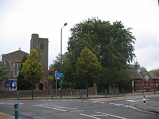
Portishead is a town and civil parish in the North Somerset unitary authority area, in the county of Somerset, England. With a population of 26,366 at the 2021 Census, the town is located on the Severn Estuary opposite Cardiff and Newport in Wales. The town is 8 miles (13 km) to the west of Bristol and 18 miles northeast of Weston-super-Mare.

<span class="mw-page-title-main">Avonmouth</span> Port and suburb of Bristol, England

Avonmouth is a port and outer suburb of Bristol, England, facing two rivers: the reinforced north bank of the final stage of the Avon which rises at sources in Wiltshire, Gloucestershire and Somerset; and the eastern shore of the Severn Estuary. Strategically the area has been and remains an important part of the region's maritime economy particularly for larger vessels for the unloading and exporting of heavier goods as well as in industry including warehousing, light industry, electrical power and sanitation. The area contains a junction of and is connected to the south by the M5 motorway and other roads, railway tracks and paths to the north, south-east and east.

<span class="mw-page-title-main">Bedminster, Bristol</span> District of Bristol, England

Bedminster, colloquially known as Bemmy, is a district of Bristol, England, on the south side of the city. It is also the name of a council ward which includes the central part of the district.

<span class="mw-page-title-main">Tickenham</span> Human settlement in England

Tickenham is a village and civil parish near Clevedon and Nailsea in North Somerset, England. The parish has a population of 910. It has a primary school, a village hall and a garden centre, but no shops, although it formerly had a post office.

<span class="mw-page-title-main">Easton in Gordano</span> Village in Somerset, England

Easton in Gordano is a village in Somerset, England, about 4+12 miles (7 km) northwest of Bristol city centre. It is part of the civil parish of Pill and Easton-in-Gordano and within the unitary authority of North Somerset. In 2011 the population of the parish was 4,828.

<span class="mw-page-title-main">Abbots Leigh</span> Human settlement in England

Abbots Leigh is a village and civil parish in North Somerset, England, about 3 miles (5 km) west of the centre of Bristol.

<span class="mw-page-title-main">Gordano Valley</span> Nature reserve in Somerset, England

Gordano is an area of North Somerset, in England. It has been designated as a National Nature Reserve.

<span class="mw-page-title-main">Clapton in Gordano</span> Human settlement in England

Clapton in Gordano is a village and civil parish in Somerset, England. It is situated within the unitary authority of North Somerset on the southern side of the Gordano Valley, immediately adjacent to the M5 motorway. The parish has a population of 348. There is a village football club, Clapton in Gordano FC. They currently run two sides with a view to continue progressing throughout the leagues. Their home ground is currently Clapton Lane, Portishead.

<span class="mw-page-title-main">Weston in Gordano</span> Human settlement in England

Weston in Gordano is a village and civil parish in Somerset, England. It is situated in the middle of the Gordano valley on the north side, and in the Unitary Authority of North Somerset, on the road between Clevedon and Portishead. The parish has a population of 301.

<span class="mw-page-title-main">Walton in Gordano</span> Human settlement in England

Walton in Gordano is a village and civil parish in North Somerset, England. It is situated in a small valley at the side of the south-western end of the Gordano Valley, about a mile from Clevedon. The parish has a population of 273.

<span class="mw-page-title-main">Royal Portbury Dock</span> Port in United Kingdom

The Royal Portbury Dock is part of the Port of Bristol, in England. It is situated near the village of Portbury on the southern side of the mouth of the Avon, where the river joins the Severn estuary — the Avonmouth Docks are on the opposite side of the Avon, within Avonmouth. The deepwater dock was constructed between 1972 and 1977, and is now a major port for the import of motor vehicles into the UK. The M5 motorway runs nearby, and the huge car storage compounds around the dock are visible from the Avonmouth Bridge. A waste industrial area west of the port is being developed as the Portbury Ashlands Nature Reserve.

<span class="mw-page-title-main">Pill, Somerset</span> Human settlement in England

Pill is a village in North Somerset, England, situated on the southern bank of the Avon, about 4 miles (6 km) northwest of Bristol city centre. The village is the largest settlement in the civil parish of Pill and Easton-in-Gordano. The former hamlets of Lodway and Ham Green are now contiguous with Pill, and the village of Easton in Gordano is nearby. The parish extends northwest beyond the M5 motorway to include the Royal Portbury Dock.

<span class="mw-page-title-main">North Somerset (UK Parliament constituency)</span>

North Somerset is a constituency represented in the House of Commons of the UK Parliament since 2010 by Liam Fox, a Conservative who served as Secretary of State for International Trade, a new position in the Cabinet, from 2016 to 2019.

<span class="mw-page-title-main">Portishead Railway</span>

The Portishead Railway is a branch line railway running from Portishead in North Somerset to the main line immediately west of Bristol, England. It was constructed by the Bristol & Portishead Pier and Railway Company, but it was always operated by its main line neighbour, and was more usually thought of as the Portishead branch or the Portishead railway.

Bristol is a city in south west England, near the Bristol Channel coast, approximately 106 miles (170 km) west of London. Several factors have influenced the development of its transport network. It is a major centre of employment, retail, culture and higher education, has many historic areas, and has a history of maritime industry. The city has a population of 450,000, with a metropolitan area of 650,000, and lies at the centre of the former County of Avon, which includes many dormitory towns, and has a population of one million.

<span class="mw-page-title-main">A369 road</span> Road in England

The A369 is an A road running from Ashton Gate junction with the A370 and the A3029 to Portishead in South West England. The first part is relatively flat and the route passes through several villages which are Leigh Woods, Abbots Leigh, Easton in Gordano to Portishead. The road crosses the M5 motorway at Junction 19 which is where the single complex Gordano services are located.

<span class="mw-page-title-main">St Mary's Church, Portbury</span> Church in Somerset, England

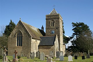
St Mary's Church in Portbury, Somerset, England, is an Anglican parish church close to the M5 motorway. It is a Grade I listed building.

<span class="mw-page-title-main">Portbury Ashlands</span>

Portbury Ashlands which is now known as Portbury Wharf Nature Reserve is a nature reserve between Portishead and the Royal Portbury Dock in Somerset, England. It was formed from the redevelopment of the area of Portishead formerly occupied by two power stations. To the east of the harbour, an area known as "the Ashlands" was used for over 50 years to get rid of power station waste which was dumped into lagoons on the site.

The Hundred of Portbury is one of the 40 historical Hundreds in the ceremonial county of Somerset, England, dating from before the Norman conquest during the Anglo-Saxon era although exact dates are unknown. Each hundred had a 'fyrd', which acted as the local defence force and a court which was responsible for the maintenance of the frankpledge system. They also formed a unit for the collection of taxes. The role of the hundred court was described in the Dooms (laws) of King Edgar. The name of the hundred was normally that of its meeting-place.

References

  1. 1 2 "2011 Census Profile". North Somerset Council. Archived from the original (Excel) on 4 January 2014. Retrieved 4 January 2014.
  2. 1 2 3 Robinson, W.J. (1915). West Country Churches. Bristol: Bristol Times and Mirror Ltd. pp. 125–131.
  3. "Somerset Hundreds". GENUKI. Retrieved 19 October 2011.
  4. Collinson, John (1791). The History and Antiquities of the County of Somerset. Cruttevell. pp.  281. Berkeley Chantry chapel Portbury.
  5. "The Avon (Structural Change) Order 1995". HMSO. Archived from the original on 30 January 2008. Retrieved 9 December 2007.
  6. "Long Ashton RD". A vision of Britain Through Time. University of Portsmouth. Retrieved 4 January 2014.
  7. Historic England. "St. Mary's Church (1311826)". National Heritage List for England . Retrieved 8 March 2009.