Exmoor is loosely defined as an area of hilly open moorland in west Somerset and north Devon in South West England. It is named after the River Exe, the source of which is situated in the centre of the area, two miles north-west of Simonsbath. Exmoor is more precisely defined as the area of the former ancient royal hunting forest, also called Exmoor, which was officially surveyed 1815–1818 as 18,810 acres (7,610 ha) in extent. The moor has given its name to a National Park, which includes the Brendon Hills, the East Lyn Valley, the Vale of Porlock and 55 km (34 mi) of the Bristol Channel coast. The total area of the Exmoor National Park is 692.8 km2 (267.5 sq mi), of which 71% is in Somerset and 29% in Devon.

West Somerset was a local government district in the English county of Somerset. The council covered a largely rural area, with a population of 34,900 in an area of 740 square kilometres (290 sq mi); it was the least populous non-unitary district in England. According to figures released by the Office for National Statistics in 2009, the population of West Somerset has the oldest average age in the United Kingdom at 52. The largest centres of population are the coastal towns of Minehead and Watchet (4,400).

Minehead is a coastal town and civil parish in Somerset, England. It lies on the south bank of the Bristol Channel, 21 miles (34 km) north-west of the county town of Taunton, 12 miles (19 km) from the border with the county of Devon and in proximity of the Exmoor National Park. The parish of Minehead has a population of approximately 11,981, making it the most populous town in the western part of the Somerset West and Taunton local government district, which in turn, is the worst area in the country for social mobility. This figure includes Alcombe and Woodcombe, suburban villages which have been subsumed into Minehead.

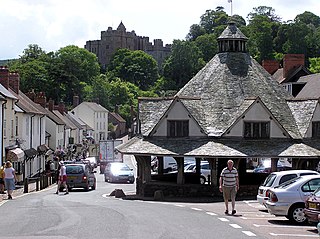
Dunster is a village, civil parish and former manor within the English county of Somerset, today just within the north-eastern boundary of the Exmoor National Park. It lies on the Bristol Channel coast 2.5 miles (4 km) south-southeast of Minehead and 20 miles (32 km) northwest of Taunton. The United Kingdom Census of 2011 recorded a parish population of 817.

Dunkery Beacon at the summit of Dunkery Hill is the highest point on Exmoor and in Somerset, England. It is also the highest point in southern England outside of Dartmoor.

Somerset is a rural county in the southwest of England, covering 4,171 square kilometres (1,610 sq mi). It is bounded on the north-west by the Bristol Channel, on the north by Bristol and Gloucestershire, on the north-east by Wiltshire, on the south-east by Dorset, and on the south west and west by Devon. It has broad central plains with several ranges of low hills. The landscape divides into four main geological sections from the Silurian through the Devonian and Carboniferous to the Permian which influence the landscape, together with water-related features.

The Tarr Steps is a clapper bridge across the River Barle in the Exmoor National Park, Somerset, England. They are located in a national nature reserve about 2.5 miles (4 km) south east of Withypool and 4 miles (6 km) north west of Dulverton.

Dunster Working Watermill is a restored 18th century watermill, situated on the River Avill, close to Gallox Bridge, in the grounds of Dunster Castle in Dunster, Somerset, England. It is a Grade II* listed building.

Holnicote in the parish of Selworthy, West Somerset, England, is a historic estate consisting of 12,420 acres of land, much situated within the Exmoor National Park.

Exton is a village and civil parish 5 miles (8 km) north-east of Dulverton and 9 miles (14 km) south-west of Dunster in Somerset, England. It lies on the River Exe on Exmoor. The parish includes the village of Bridgetown and covers 2,017 ha, all of which is within the National Park.

Bats Castle is an Iron Age hill fort at the top of a 213 metres (699 ft) high hill in the parish of Carhampton south south west of Dunster in Somerset, England.

Black Ball Camp is an Iron Age hill fort South West of Dunster, Somerset, England on the northern summit of Gallox Hill. It is a Scheduled Ancient Monument.

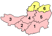
The Grade I listed buildings in Somerset, England, demonstrate the history and diversity of its architecture. The ceremonial county of Somerset consists of a non-metropolitan county, administered by Somerset County Council, which is divided into five districts, and two unitary authorities. The districts of Somerset are West Somerset, South Somerset, Taunton Deane, Mendip and Sedgemoor. The two administratively independent unitary authorities, which were established on 1 April 1996 following the breakup of the county of Avon, are North Somerset and Bath and North East Somerset. These unitary authorities include areas that were once part of Somerset before the creation of Avon in 1974.

The Gallox Bridge in Dunster, Somerset, England dates from the 15th century. It has been designated as a Grade I listed building and scheduled monument. The bridge is in the guardianship of English Heritage.

The West Somerset Coast Path is a long-distance footpath that links the northern end of the South West Coast Path to the River Parrett Trail in Somerset, England, UK.

The Butter Cross in Dunster within the English county of Somerset is a Grade II* listed building and ancient monument. The cross was originally erected in the late 14th or early 15th century in the main street, and was moved to its current site in the late 18th or early 19th century. Although the head of the cross is missing, the shaft and socket stone are original. The cross is in the care of English Heritage and is managed by the National Trust.

There are over 670 scheduled monuments in the ceremonial county of Somerset in South West England. The county consists of a non-metropolitan county, administered by Somerset County Council, which is divided into five districts, and two unitary authorities. The districts of Somerset are West Somerset, South Somerset, Taunton Deane, Mendip and Sedgemoor. The two administratively independent unitary authorities, which were established on 1 April 1996 following the breakup of the county of Avon, are North Somerset and Bath and North East Somerset. These unitary authorities include areas that were once part of Somerset before the creation of Avon in 1974.

Richard Phelps (1710–1785) was an 18th-century English portrait painter and designer. He painted portraits of gentry, a number of which are in the National Trust, Dunster Castle, University of Oxford, National Portrait Gallery, London, and other museums. The British Museum has an album of 312 of his drawings. Phelps was also a landscape designer, who was hired by Henry Fownes Luttrell to update the grounds of Dunster Castle.
West Somerset was a local government district in the English county of Somerset. It merged with Taunton Deane to form Somerset West and Taunton on 1 April 2019.


