West Somerset Coast Path

Last updated

West Somerset Coast Path
West Somerset Coast Path sign.JPG
West Somerset Coast Path sign
Length25 mi (40 km)
Location Somerset, England
Designation UK National Trail
Trailheads Minehead, Steart Peninsula
UseHiking
Elevation
Lowest pointSea level
Hiking details
SeasonAll year

The West Somerset Coast Path is a long-distance footpath that links the northern end of the South West Coast Path to the River Parrett Trail in Somerset, England, UK. [1]

Contents

In March 2016 a 58 miles (93 km) stretch of the England Coast Path from Brean Down to Minehead, which incorporates the West Somerset Coast Path, was opened and designated as part of the England Coast Path. [2]

Route

It runs from the hamlet of Steart on the Steart Peninsula, and passes through the villages of Kilve, West Quantoxhead, Williton, Watchet, Blue Anchor, and Dunster beach to Minehead. [3]

The beach at Kilve was described by William Wordsworth, the Romantic poet, as "Kilve's delightful shore". [4] Kilve Pill, where the stream from Holford runs into the sea, was once a tiny port, used for importing culm, an inferior type of coal which was used in the limeburning process. It was also the site for "glatting" which was the hunting of conger eels by dogs. [5] On the shore a Saint Keyne serpent can be seen, which a local legend says is a snake turned to stone, but is in reality an ammonite. [6] It is just possible to make out the remains of a stone jetty and the ruins of a lime kiln nearby. Here the limestone was burnt to provide farmers with the lime to spread on their fields. The limestone carrier Laurina was wrecked at Kilve in 1876. [5]

From Williton to Minehead the route is close to the track of the West Somerset Railway which opened in 1862 and was extended from Watchet to Minehead by the Minehead Railway in 1874. Although just a single track, improvements were needed in the first half of the twentieth century to accommodate the significant number of tourists that wished to travel to the Somerset coast. Despite this traffic it was closed in 1971 but was then reopened in 1976 as a heritage railway.

Watchet is a harbour town, which, according to the Anglo-Saxon Chronicle , was plundered by Danes led by Ohtor and Rhoald [7] in 987 and 997. It is known that it was in frequent use by small boats in 1564 possibly for the import of salt and wine from France. [5] During the English Civil War Royalist reinforcements for the siege of Dunster Castle was sent by sea, but the tide was on the ebb and a troop of Roundheads rode into the shallows and forced the ship to surrender, so a ship at sea was taken by a troop of horse. [8] The primitive jetty was damaged in a storm of 1659 and a larger, stronger pier was built in the early 18th century supported by local wool merchants, although by 1797 the largest export was kelp made by burning seaweed for use in glass making. In the 19th century trade increased with the export of iron ore from the Brendon Hills, paper, flour and gypsum. [9] Harbour trade was aided by the coming of the railway. In the mid-1860s two independent railways terminated at Watchet. The West Somerset Mineral Railway ran down from the iron mines on the Brendon Hills, and the West Somerset Railway came up from the Bristol & Exeter Railway at Norton Fitzwarren. Both lines made extensive use of the harbour at Watchet from where iron ore was shipped across the Bristol Channel for smelting at Ebbw Vale in South Wales. [5]

The foreshore at Watchet is rocky, with a high 6 metres (20 ft) tidal range. The cliffs between Watchet and Blue Anchor show a distinct pale, greenish blue colour, resulting from the coloured alabaster found there. The name "Watchet" or "Watchet Blue" was used in the 16th century to denote this colour. [10] [11] Daw's Castle, about 0.5 miles (0.80 km) west of Watchet, is a hill fort situated on a sea cliff about 80 metres (260 ft) above the sea. The fort may be of Iron Age origin, but was (re)built and fortified as a burh by King Alfred, as part of his defence against Viking raids from the Bristol Channel around 878 AD. [12] [13]

The Blue Anchor to Lilstock Coast SSSI is a 742.8 hectare geological Site of Special Scientific Interest. It provides an outstanding series of sections through the Early Jurassic Lower Lias, spanning the Hettangian and Pliensbachian Stages and named the "Lilstock Formation". This sequence and the good Rhaetian succession beneath are repeatedly affected by faulting, [14] making it of interest to geologists and fossil hunters. It also displays coastal geomorphology which demonstrates a particularly well-developed series of intertidal shore platforms varying in width from about 200-600m. The cliff and beach are rich in reptile remains, including complete skeletons. Lilstock also yields ammonites, shells and fish remains. A unique specimen of an ichthyosaur, named Excalibosaurus costini MacGowan, in which the lower jaw is shorter than the upper was found in the Lower Jurassic Sinemurian Stage, Lower Lias beds on the foreshore at Lilstock and is now in the Bristol City Museum and Art Gallery. [15] The Triassic cliffs have geological interest for the variety of fossils. The coloured alabaster found in the cliffs gave rise to the name of the colour "Watchet Blue". [16]

Dunster Beach, which includes the mouth of the River Avill, is located half a mile from the village, and used to have a significant harbour, known as Dunster Haven, which was used for the export of wool from Saxon times; [17] however, it was last used in the 17th century and has now disappeared among the dykes, meadows and marshes near the shore. [18] The beach site has a number of privately owned beach huts (or chalets as some owners call them) along with a small shop, a tennis court and a putting green. The chalets, measuring 18 by 14 feet (5.5 by 4.3 m), can be let out for holidays; some owners live in them all the year round. [19]

Route and points of interest

Map all coordinates using: OpenStreetMap  
Download coordinates as: KML
Point Coordinates
(Links to map resources)
OS Grid Ref Notes
Start 51°12′32″N3°02′02″W / 51.209°N 3.034°W / 51.209; -3.034 (Start) ST278461Steart on the Steart Peninsula
Lilstock 51°12′00″N3°11′31″W / 51.200°N 3.192°W / 51.200; -3.192 (Lilstock) ST167452
Kilve 51°11′31″N3°13′34″W / 51.192°N 3.226°W / 51.192; -3.226 (Kilve Beach) ST143443
West Quantoxhead 51°10′52″N3°16′19″W / 51.181°N 3.272°W / 51.181; -3.272 (West Quantoxhead) ST111432
Watchet 51°10′55″N3°19′44″W / 51.182°N 3.329°W / 51.182; -3.329 (Watchet) ST072434
Blue Anchor 51°10′55″N3°23′56″W / 51.182°N 3.399°W / 51.182; -3.399 (Blue Anchor) ST022434
Dunster 51°11′38″N3°25′48″W / 51.194°N 3.430°W / 51.194; -3.430 (Dunster Beach) ST001449
End 51°12′32″N3°28′19″W / 51.209°N 3.472°W / 51.209; -3.472 (End) SS972466 Minehead

Related Research Articles

Bridgwater Bay Bay in Bristol Channel

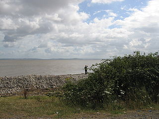
Bridgwater Bay is on the Bristol Channel, 5 kilometres (3.1 mi) north of Bridgwater in Somerset, England at the mouth of the River Parrett and the end of the River Parrett Trail. It stretches from Minehead at the southwestern end of the bay to Brean Down in the north. The area consists of large areas of mudflats, saltmarsh, sandflats and shingle ridges, some of which are vegetated. It has been designated as a Site of Special Scientific Interest (SSSI) covering an area of 3,574.1 hectares since 1989, and is designated as a wetland of international importance under the Ramsar Convention. The risks to wildlife are highlighted in the local Oil Spill Contingency Plan.

Watchet Human settlement in England

Watchet is a harbour town, civil parish and electoral ward in the English county of Somerset, with a population of 3,785. It is situated 15 miles (24 km) west of Bridgwater, 15 miles (24 km) north-west of Taunton, and 9 miles (14 km) east of Minehead. The town lies at the mouth of the Washford River on Bridgwater Bay, part of the Bristol Channel, and on the edge of Exmoor National Park.

A39 road Road in south west England

The A39 is an A road in south west England. It runs south-west from Bath in Somerset through Wells, Glastonbury, Street and Bridgwater. It then follows the north coast of Somerset, Devon and Cornwall through Williton, Minehead, Porlock, Lynmouth, Barnstaple, Bideford, Stratton, Camelford, Wadebridge and St Columb Major. It then joins the route of the A30 road for around 5 miles (8.0 km), re-emerging near Zelah to head for the south Cornish coast via Truro and Falmouth.

Minehead Human settlement in England

Minehead is a coastal town and civil parish in Somerset, England. It lies on the south bank of the Bristol Channel, 21 miles (34 km) north-west of the county town of Taunton, 12 miles (19 km) from the border with the county of Devon and in proximity of the Exmoor National Park. The parish of Minehead has a population of approximately 11,981, making it the most populous town in the western part of the Somerset West and Taunton local government district, which in turn, is the worst area in the country for social mobility. This figure includes Alcombe and Woodcombe, suburban villages which have been subsumed into Minehead.

Porlock Human settlement in England

Porlock is a coastal village in Somerset, England, 5 miles (8 km) west of Minehead. It has a population of 1,440.

Kilve Human settlement in England

Kilve is a village in the Somerset West and Taunton district of Somerset, England, within the Quantock Hills Area of Outstanding Natural Beauty, the first AONB to be established, in 1957.

River Barle River in Somerset and Devon, England

The River Barle runs from the Chains on northern Exmoor, in Somerset, England to join the River Exe at Exebridge, Devon. The river and the Barle Valley are both designated as biological Sites of Special Scientific Interest.

Blue Anchor to Lilstock Coast SSSI

Blue Anchor to Lilstock Coast SSSI is a 742.8 hectare geological Site of Special Scientific Interest between Blue Anchor and Lilstock in Somerset, notified in 1971.

Porlock Weir Human settlement in England

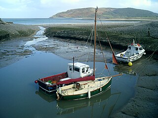
Porlock Weir, about 1.5 miles west of the inland village of Porlock, Somerset, England, is a small settlement around a harbour. Porlock means place of the port and Porlock Weir is its harbour. Weir refers to salmon stakes and traps that were situated along the shore. It is a popular visitor attraction.

Lilstock Human settlement in England

Lilstock is a hamlet in the civil parish of Stringston within the Somerset West and Taunton district of Somerset, England. It is 12 miles (19 km) north-west of Bridgwater, and 8 miles (13 km) north-east of Williton. It is on the coast of Bridgwater Bay on the Bristol Channel, near the Hinkley Point nuclear power stations.

Blue Anchor Human settlement in England

Blue Anchor is a seaside village, in the parish of Old Cleeve, close to Carhampton in the Somerset West and Taunton district of Somerset, England. The village takes its name from a 17th-century inn; the bay, Blue Anchor Bay, was previously known as Cleeve Bay. The bay and inn were the subjects of a watercolour by JMW Turner in 1818, now in the Lady Lever Gallery, Port Sunlight.

Withycombe Human settlement in England

Withycombe is a village and civil parish 2.5 miles (4 km) south east of Dunster, and 5 miles (8 km) from Minehead within the Exmoor National Park in the Somerset West and Taunton district of Somerset, England. The parish includes the village of Rodhuish.

Church of St Dubricius, Porlock Church in West Somerset, UK

The Church of St Dubricius in Porlock, Somerset, England dates from the 13th century. The church has been designated by English Heritage as a Grade I listed building.

Church of St Mary Magdalene, Winsford

The Church of St Mary Magdalene in Winsford, Somerset, England, dates back to the Norman period before the 13th century and has been designated by English Heritage as a Grade I listed building.

Church of St Nicholas, Withycombe

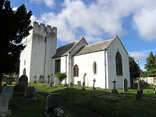
The Church of St Nicholas in Withycombe, Somerset, England dates from the 13th century and has been designated by English Heritage as a Grade I listed building.

St Andrews Church, Cheddar

The Church of St Andrew in Cheddar, Somerset, England dates from the 14th century and has been designated as a Grade I listed building.

Church of St Peter and St Paul, Shepton Mallet

The Church of St Peter and St Paul in Shepton Mallet, Somerset, England, dates from the 12th century and has been designated as a Grade I listed building.

Church of All Saints, Martock

The Church of All Saints in Martock, Somerset, England dates from the 13th century and has been designated as a Grade I listed building.

Ilchester Museum Local museum in Somerset, England

Ilchester Museum is a small local museum in Ilchester, Somerset, England.

Church of St Michael, Minehead

The Anglican Church of St Michael in Minehead, Somerset, England was built in the 15th century. It is a Grade II* listed building.

References

  1. "West Somerset Coast Path". Somerset County Council. Retrieved 20 October 2009.
  2. "England Coast Path new stretch opens in Somerset". BBC. Retrieved 15 March 2016.
  3. "West Somerset Coast Path". Long Distance Walkers Association. Retrieved 20 October 2009.
  4. Dunning, Robert (1980). Somerset and Avon. Edinburgh: John Bartholomew and Son. ISBN   0-7028-8380-8.
  5. 1 2 3 4 Farr, Grahame (1954). Somerset Harbours. London: Christopher Johnson. pp. 119–120.
  6. Leete-Hodge, Lornie (1985). Curiosities of Somerset. Bodmin: Bossiney Books. p. 45. ISBN   0-906456-98-3.
  7. Waite, Vincent (1964). Portrait of the Quantocks. London: Robert Hale. ISBN   0-7091-1158-4.
  8. Leete-Hodge, Lornie (1985). Curiosities of Somerset. Bodmin: Bossiney Books. pp. 41–42. ISBN   0-906456-98-3.
  9. Farr, Grahame (1954). Somerset Harbours. London: Christopher Johnson. pp. 125–137.
  10. Leete-Hodge, Lornie (1985). Curiosities of Somerset. Bodmin: Bossiney Books. p. 41. ISBN   0-906456-98-3.
  11. "Article from Issue Number 12/1 February 2005". Open University Geological Society (London Branch). Archived from the original on 18 February 2007. Retrieved 8 October 2008.
  12. Adkins, Lesley; Adkins, Roy (1992). A Field Guide to Somerset Archaeology. Wimborne, Dorset: Dovecote Press. pp. 46–47. ISBN   0-946159-94-7.
  13. Aston, Michael (1982). Ian Burrow (ed.). The Archaeology of Somerset. ISBN   0-86183-028-8.
  14. "Blue Anchor to Lilstock Coast SSSI" (PDF). English Nature. Retrieved 31 December 2007.
  15. "Collections — Geology — page 7 - Reptiles". Bristol City Museum. Archived from the original on 20 May 2011. Retrieved 31 December 2007.
  16. Leete-Hodge, Lornie (1985). Curiosities of Somerset. Bodmin: Bossiney Books. p. 41. ISBN   0-906456-98-3.
  17. Gathercole, Clare. "Dunster" (PDF). Somerset Urban Archaeological Survey. Somerset County Council. Archived from the original (PDF) on 17 July 2011. Retrieved 2 February 2010.
  18. Farr, Grahame (1954). Somerset Harbours. London: Christopher Johnson. pp. 138–140.
  19. The history of Dunster Beach by Bernard Concannon, Monkspath Books, 1995 ( ISBN   0-9526884-0-9)