Blue Anchor | |
---|---|
![]() The Pub | |
Location within Somerset | |
OS grid reference | ST022433 |
Civil parish | |
District | |
Shire county | |
Region | |
Country | England |
Sovereign state | United Kingdom |
Post town | MINEHEAD |
Postcode district | TA24 |
Dialling code | 01984 |
Police | Avon and Somerset |
Fire | Devon and Somerset |
Ambulance | South Western |
UK Parliament | |
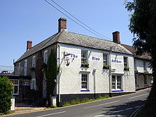
Blue Anchor is a seaside village, in the parish of Old Cleeve, close to Carhampton in the Somerset West and Taunton district of Somerset, England. The village takes its name from a 17th-century inn; [1] the bay, Blue Anchor Bay, was previously known as Cleeve Bay. [1] The bay and inn were the subjects of a watercolour by J. M. W. Turner in 1818, now in the Lady Lever Gallery, Port Sunlight. [2]
The village marks one end of the Blue Anchor to Lilstock Coast Site of Special Scientific Interest along which the Triassic cliffs have geological interest for the variety of fossils. The coloured alabaster found in the cliffs gave rise to the name of the colour "Watchet Blue". [3]
The village lies on the route of the West Somerset Coast Path and Celtic Way Exmoor Option.
Blue Anchor railway station is a station on the West Somerset Railway, a heritage railway in Somerset. It is situated in the village and houses the museum of the West Somerset Steam Railway Trust.
Within the village is the only example of an updraught brick kiln known to have survived in Somerset. [4] It was built around 1830, supplied by small vessels carrying limestone to the small culm landing, [5] and is now used as a garage. The kiln is thought to have been used until the 1870s when the large-scale production of bricks in Bridgwater rendered small brickyards uneconomic. [6]
Marshwood farmhouse dates from the late 15th century and was originally a manor house or grange. It has been designated by English Heritage as a Grade II* listed building. [7]
Coincidentally there is another Blue Anchor Inn directly north across the Bristol Channel in East Aberthaw, The Vale of Glamorgan. [8]
The Quantock Hills west of Bridgwater in Somerset, England, consist of heathland, oak woodlands, ancient parklands and agricultural land. They were England's first Area of Outstanding Natural Beauty, designated in 1956.
Watchet is a harbour town, civil parish and electoral ward in the county of Somerset, England, with a population in 2011 of 3,785. It is situated 15 miles (24 km) west of Bridgwater, 15 miles (24 km) north-west of Taunton, and 9 miles (14 km) east of Minehead. The town lies at the mouth of the Washford River on Bridgwater Bay, part of the Bristol Channel, and on the edge of Exmoor National Park.
Yatton is a village and civil parish within the unitary authority of North Somerset, which falls within the ceremonial county of Somerset, England. It is located 11 miles (18 km) south-west of Bristol. Its population in 2011 was 7,552. The parish includes Claverham, a small village which was originally a farming hamlet.
Woodspring Priory is a former Augustinian priory. It is near the scenic limestone promontory of Sand Point and Middle Hope, owned by the National Trust, beside the Severn Estuary about 3 miles (5 km) north-east of Weston-super-Mare, within the English unitary authority of North Somerset. Many of the buildings are Grade I listed, and the whole site is scheduled as an ancient monument.
Williton is a large village and civil parish in Somerset, England, at the junction of the A39, A358 and B3191 roads, on the coast 2 miles (3.2 km) south of Watchet between Minehead, Bridgwater and Taunton in the now-defunct Somerset West and Taunton district.
Blagdon is a village and civil parish in the ceremonial county of Somerset, within the unitary authority of North Somerset, in England. It is located in the Mendip Hills, a recognised Area of Outstanding Natural Beauty. According to the 2021 census it has a population of 1,184. The village is about 12 miles (19 km) east of Weston-super-Mare and 12 miles south west of Bristol, on the A368 road to Bath.
Wylye is a village and civil parish on the River Wylye in Wiltshire, England. The village is about 9+1⁄2 miles (15 km) northwest of Salisbury and a similar distance southeast of Warminster.
Kilve is a village in the Somerset West and Taunton district of Somerset, England, within the Quantock Hills Area of Outstanding Natural Beauty, the first AONB to be established, in 1957.
Aberthaw is an area containing the villages of East Aberthaw and West Aberthaw, on the coast of South Wales about 5 miles (8 km) west of Barry. It is home to Aberthaw Cement Works, Aberthaw Lime Works, and Aberthaw Power Station, a decommissioned coal power station that was linked to the South Wales Valleys via the Vale of Glamorgan Railway. The area is historically within the parish of Penmark in the Vale of Glamorgan. The two villages of West and East Aberthaw are separated by the River Thaw. The village of East Aberthaw, near Rhoose, has a 13th-century pub. The village Baptist Chapel and Mission Room no longer exist as such and have been converted for other uses.
Cleeve Abbey is a medieval monastery located near the village of Washford, in Somerset, England. It is a Grade I listed building and has been scheduled as an ancient monument.
Washford railway station is a station on the West Somerset Railway, a heritage railway in England. The station is situated in the village of Washford, which is itself within the civil parish of Old Cleeve in the county of Somerset.
Warnham is a village and civil parish in the Horsham district of West Sussex, England. The village is centred 2 miles (3.2 km) north-northwest of Horsham, 31 miles (50 km) from London, to the west of the A24 road. The parish is in the north-west of the Weald.
Washford is a village on the Washford River in the civil parish of Old Cleeve, Somerset, England. The village is next to Cleeve Abbey, one of the best-preserved medieval monasteries in England. It centred in a valley close to the Bristol Channel on the A39 road 7 miles (11 km) east of the resort town of Minehead and 2 miles (3 km) southwest of the port of Watchet.
Wanstrow is a village and civil parish 6 miles (9.7 km) south west of Frome in Somerset, England. The parish includes the village of Cloford.
West Pennard is a village and civil parish east of Glastonbury, situated at the foot of Pennard Hill, in Somerset, England. The parish includes the hamlets of Coxbridge and Woodlands.
Cleeve is a village and civil parish in the ceremonial county of Somerset, England. It is situated within the unitary authority of North Somerset, 9 miles (14 km) south west of Bristol and has a population of 902.
Old Cleeve is a village 5 miles (8 km) south east of Minehead in the Somerset West and Taunton district of Somerset, England, and also a civil parish. The civil parish of Old Cleeve covers an area of 2,092 hectares and includes the villages of Old Cleeve, Roadwater and Washford as well as hamlets such as Bilbrook, Chapel Cleeve, Golsoncott and Leighland Chapel. Approximately half the parish lies within the Exmoor National Park. The remaining half is on the southern edge of Exmoor. The village has been in existence since the early 13th century. The village held its first council meeting in 1711. By the 1720s the parish had several churches, in which to meet. The town hall was built in 1727. The first church here was built in 1694, built by the Eastern Christian Society. This church was destroyed in a fire in 1847, and has been rebuilt and restored. In 2011, the population of the parish was 1,672.
Seend is a village and civil parish about 3 miles (5 km) southeast of the market town of Melksham, Wiltshire, England. It lies about 3.5 miles (6 km) west of Devizes and 5.5 miles (9 km) northeast of the county town of Trowbridge. The parish includes the sub-village of Seend Cleeve and the hamlets of Inmarsh, Martinslade, Seend Head, Sells Green and The Stocks.
Lilstock is a hamlet in the civil parish of Stringston in Somerset, England. It is 12 miles (19 km) north-west of Bridgwater, and 8 miles (13 km) north-east of Williton. It is on the coast of Bridgwater Bay on the Bristol Channel, near the Hinkley Point nuclear power stations.
The West Somerset Coast Path is a long-distance footpath that links the northern end of the South West Coast Path to the River Parrett Trail in Somerset, England, UK.
Media related to Blue Anchor at Wikimedia Commons