List of national nature reserves in Somerset

Last updated

Somerset UK district map 2010 (blank).svg
Red pog.svg
1
Red pog.svg
2
Red pog.svg
3
Red pog.svg
4
Red pog.svg
5
Red pog.svg
6
Red pog.svg
7
Red pog.svg
8
Red pog.svg
9
Red pog.svg
10
Red pog.svg
11
Red pog.svg
12
Red pog.svg
13
Red pog.svg
14
Red pog.svg
15
National nature reserves in Somerset

The ceremonial county of Somerset consists of a non-metropolitan county, administered by Somerset County Council, which is divided into five districts, and two unitary authorities. The districts of Somerset are West Somerset, South Somerset, Taunton Deane, Mendip and Sedgemoor. The two administratively independent unitary authorities, which were established on 1 April 1996 following the breakup of the county of Avon, are North Somerset and Bath and North East Somerset.

Contents

National nature reserves in England (NNR) are designated under Part III of the National Parks and Access to the Countryside Act 1949 that are deemed to be of national importance by Natural England as key places for wildlife and natural features in England using section 35(1) of the Wildlife and Countryside Act 1981. [1] They were established to protect the most significant areas of habitat and of geological formations. NNRs are managed on behalf of the nation, many by Natural England themselves, but also by non-governmental organisations, including Avon Wildlife Trust or the Somerset Wildlife Trust, the National Trust, and the Royal Society for the Protection of Birds. [2]

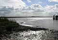
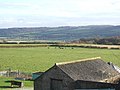
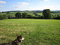
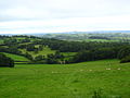
There are 15 national nature reserves in the county. The largest is Bridgwater Bay which has been recognised under the Ramsar Convention and covers 2,639 hectares (6,521 acres) of mud flats, saltmarsh, sandflats and shingle ridges. The smallest is Hardington Moor at 8.7 hectares (21.5 acres) in area. Several of the sites are associated with rivers and low-lying areas of the Somerset Levels. The highest is Dunkery and Horner Wood which covers 1,604 hectares (3,964 acres) of wet and dry heathland, ancient woodland and open grassland on Exmoor including Dunkery Beacvon, the highest point in the county. Ebbor Gorge is important for both biological and geological interest.

Map all coordinates using: OpenStreetMap  
Download coordinates as: KML
GPX (primary)
GPX (secondary)
GPX (all)

Sites

SitePhotographDistrictArea [lower-alpha 1] Location [lower-alpha 2] Map [lower-alpha 3] Details [lower-alpha 4] Description
Barrington Hill Water trough, Barrington Hill (geograph 4074875).jpg South Somerset 17.8 hectares (44.0 acres) Broadway
50°56′53″N2°59′49″W / 50.948°N 2.997°W / 50.948; -2.997 (Barrington Hill)
ST300170
Map Details This site comprises four meadows surrounded by well-established hedges on gently sloping clay-rich soils. It is an outstanding example of a traditionally managed unimproved neutral grassland of a type now rare in Britain. The meadows belong to a type characterised by the widespread occurrence of sweet vernal grass (Anthoxanthum odoratum), crested dog's-tail (Cynosurus cristatus), cowslip (Primula veris) and green-winged orchid (Orchis morio). A total of 74 species of orchids have so far been recorded. This site is one of only three localities in Britain in which the grass Gaudinia fragilis is a prominent feature of the sward. [3]
Bridgwater Bay Mudflats at Combwich.jpg Sedgemoor 2,639 hectares (6,521 acres) Otterhampton
51°10′59″N3°04′48″W / 51.183°N 3.080°W / 51.183; -3.080 (Bridgwater Bay)
ST246431
Map Details Bridgwater Bay is on the Bristol Channel, 5 kilometres (3.1 mi) north of Bridgwater at the mouth of the River Parrett and the end of the River Parrett Trail. It consists of large areas of mud flats, saltmarsh, sandflats and shingle ridges, some of which are vegetated. It has been designated as a Site of Special Scientific Interest since 1989, [4] and is designated as a wetland of international importance under the Ramsar Convention. [5] In addition to the rivers, Parrett, Brue and Washford several of the man-made drainage ditches, including the River Huntspill, from the Somerset Levels, including the "Pawlett Hams", also drain into the bay.
Dunkery and Horner Wood Dunkery Beacon.jpg West Somerset 1,604 hectares (3,964 acres) Luccombe
51°11′20″N3°33′32″W / 51.189°N 3.559°W / 51.189; -3.559 (Dunkery and Horner Wood)
SS910445
Map Details The Dunkery and Horner Wood NNR is one of the largest in England. It includes Dunkery Hill, the highest point on Exmoor and in Somerset, wet and dry heathland, ancient woodland and open grassland. Much of the NNR is within the National Trust-owned Holnicote Estate. [6]
Ebbor Gorge Ebbor Gorge 2.jpg Mendip 47 hectares (116 acres) St Cuthbert Out
51°14′02″N2°40′55″W / 51.234°N 2.682°W / 51.234; -2.682 (Ebbor Gorge)
ST525485
Map Details Ebbor Gorge is a limestone gorge. It was donated to the National Trust in 1967 and is now managed by Natural England. The gorge was cut into the Clifton Down Limestone, an example of Carboniferous Limestone, by water. The floor of the gorge is impermeable Millstone Grit and Lower Coal Measures. [7] [8] The rare mineral mendipite has also been found. [9] The site was occupied by humans in the Neolithic Era and their tools and flint arrow heads have been discovered, along with pottery from the Bronze Age. [10] [11] [12] There are also fossils of small mammals from the end of the last ice age. The nature reserve provides a habitat for a variety of flora and fauna, including flowers, butterflies and bats. [13]
Gordano Valley Gordano Valley from Hill Top - geograph.org.uk - 208937.jpg North Somerset 126 hectares (311 acres) Walton in Gordano
51°27′11″N2°48′50″W / 51.453°N 2.814°W / 51.453; -2.814 (Gordano Valley)
ST433731
Map Details A Site of Special Scientific Interest, for ornithological, entomological and stratigraphic interest. Several sites in the valley are managed by the Avon Wildlife Trust as nature reserves. These include; Weston Big Wood, Clapton Moor, Weston Moor and Walton Common. The unimproved wet meadow communities largely consist of variants of the nationally rare blunt-flowered rush–marsh thistle (Juncus subnodulosus–cirsium palustre), soft/sharp flowered rush–marsh bedstraw (Juncus effusus/acutiflorus–Galium palustre), purple moorgrass–meadow thistle (Molinia caerulea–cirsium dissectum) and crested dog's-tail–common knapweed (Cynosurus cristatus–centaurea nigra) community types. In total over 130 species of flowering plant have been recorded including 3 species of orchids, 21 grasses and 14 sedges. The extensive system of rhynes and field ditches contains a rich flora which includes three nationally scarce species: water parsnip (Sium latafolium), whorled water milfoil (Myriophyllum verticillatum) and fen pondweed (Potamogeton coloratus). [14]
Ham Wall Ham Wall Nature Reserve - geograph.org.uk - 230999.jpg Mendip 87.27 hectares (215.6 acres) Sharpham
51°09′18″N2°40′55″W / 51.155°N 2.682°W / 51.155; -2.682 (Ham Wall)
ST525485
Map Details The Ham Wall national nature reserve, 4 kilometres (2.5 mi) west of Glastonbury, on the Somerset Levels in the valley of the River Brue is managed by the Royal Society for the Protection of Birds. [15] [16] It is part of the Brue Valley Living Landscape conservation project which aims to restore, recreate and reconnect habitat. This new wetland habitat has been established from out peat diggings and now consists of areas of reedbed, wet scrub, open water and peripheral grassland and woodland. Many bird species live on or visit the site including the bearded tit, bittern, Cetti's warbler, hobby and starling. [17]
Hardington Moor Hardingtonmoor.jpg South Somerset 8.7 hectares (21.5 acres) Hardington Mandeville
50°54′50″N2°41′28″W / 50.914°N 2.691°W / 50.914; -2.691 (Hardington Moor)
ST515130
Map Details Hardington Moor is a biological Site of Special Scientific Interest between Hardington Mandeville and West Coker, notified in 1994. Hardington Moor national nature reserve covers partly calcareous clay-rich soils on sloping ground and comprises three meadows surrounded by established hedges. The meadows are examples of species-rich unimproved neutral grassland, which is now nationally rare. The rare French oat-grass is very abundant on the site and the fields are home to a wide variety of plant species, most notably adder's tongue, corky-fruited water-dropwort and large numbers of green-winged orchid. Invertebrates found at the site include butterflies such as gatekeeper, small tortoiseshell and common blue. Less commonly seen are large skipper, green-veined white and green hairstreak. [18]
Hawkcombe Woods Homebush Farm, Exmoor - geograph.org.uk - 7192.jpg West Somerset 98 hectares (242 acres) Porlock
51°12′07″N3°35′35″W / 51.202°N 3.593°W / 51.202; -3.593 (Hawkcombe Woods)
SS886459
Map Details Hawkcombe Woods is near Porlock on Exmoor. [19] The 101 hectares (249.6 acres) woodlands are notable for their lichens, heath fritillary butterfly, red wood ant colonies, dead wood invertebrates and ancient pollards. [20] They are part of the North Exmoor Site of Special Scientific Interest.
Huntspill River Huntspill River.jpg Sedgemoor 149 hectares (368 acres) East Huntspill
51°12′29″N3°00′50″W / 51.208°N 3.014°W / 51.208; -3.014 (Huntspill River)
ST291459
Map Details The River Huntspill (or Huntspill River) is an artificial river, in the Somerset Levels. It was built in 1940 to supply process water to ROF Bridgwater, and has resulted in reduced flooding of the lower Brue Valley. Huntspill Sluice at the river's western end, also known as West Huntspill Sluice, separates it from the River Parrett. A stretch of the river, from Gold Corner to Huntspill Sluice (excluding the Cripps River), is a national nature reserve. The NNR is managed by the Environment Agency. The river discharges into the River Parrett, just south of Highbridge which then flows into Bridgwater Bay. [21] Public access to the site is restricted.
Leigh Woods Uk bristol lw2.jpg North Somerset 64 hectares (158 acres) Leigh Woods
51°27′47″N2°38′20″W / 51.463°N 2.639°W / 51.463; -2.639 (Leigh Woods)
ST559733
Map Details Leigh Woods is an area of woodland on the south-west side of the Avon Gorge, close to the Clifton Suspension Bridge, within North Somerset opposite the English city of Bristol and north of the Ashton Court estate, of which it formed a part. In 1909 part of the woodland was donated to the National Trust by George Alfred Wills, to prevent development of the city beside the gorge following the building of the Leigh Woods suburb. Areas not owned by the National Trust have since been taken over by the Forestry Commission. It is included in the Avon Gorge Site of Special Scientific Interest, [22] [23] Rare trees include multiple species of Sorbus with at least nine native and four imported species. Bristol rockcress (Arabis scabra) which is unique to the Avon Gorge can be seen flowering in April; various species of orchids and western spiked speedwell (Veronica spicata) are common in June and July.
Rodney Stoke Mendip valley from Stoke Woods.jpg Mendip 51 hectares (126 acres) Rodney Stoke
51°15′11″N2°43′44″W / 51.253°N 2.729°W / 51.253; -2.729 (Rodney Stoke)
ST492507
Map Details Rodney Stoke is a biological Site of Special Scientific Interest, just north of the village of Rodney Stoke in the Mendip Hills. Part of the site is a national nature reserve and part a Nature Conservation Review Woodland site. This site supports a mosaic of ancient semi-natural broadleaved woodland, scrub and species-rich unimproved grassland. Two nationally rare plants occur at Rodney Stoke: purple gromwell (Lithospermum purpurocaeruleum) and the endemic whitebeam (Sorbus anglica). The site supports a diverse fauna. Badgers (Meles meles) are common and two or three setts are occupied each year. Noctule bats (Nyctalus noctula) and pipistrelle bats (Pipistrellus pipistrellus) roost in Big Stoke. Breeding birds include buzzard (Buteo buteo) and spotted flycatcher (Muscicapa striata). Small enclosures and tall hedges provide sheltered conditions that are ideal for many species of invertebrate. Butterflies are well represented with marbled white (Melanargia galathea), purple hairstreak (Quercusia quercus), brown argus (Aricia agestis) and grayling (Hipparchia semele). [24] General access is only via the one footpath across the site.
Shapwick Heath Shapwickheath.jpg Sedgemoor 509 hectares (1,258 acres) Shapwick
51°09′32″N2°48′50″W / 51.159°N 2.814°W / 51.159; -2.814 (Shapwick Heath)
ST436400
Map Details Shapwick Heath is a biological Site of Special Scientific Interest and national nature reserve [25] between Shapwick and Westhay. It is part of the Brue Valley Living Landscape conservation project. Shapwick Heath, part of the Avalon Marshes in the Somerset Levels Wetlands, and managed as a national nature reserve by Natural England, is a former raised bog lying in the basin of the River Brue. The site supports a diverse community of terrestrial and aquatic invertebrates. National rarities are the greater silver diving beetle (Hydrophilus piceus) and the lesser silver diving beetle (Hydrochara caraboides) which is now confined nationally to the Brue Basin Peat Moors. [26]
Somerset Levels Rhyne pointing towards Moorlinch Church - geograph.org.uk - 1706746.jpg Sedgemoor 463 hectares (1,144 acres) Moorlinch
51°07′16″N2°52′55″W / 51.121°N 2.882°W / 51.121; -2.882 (Somerset Levels)
ST383361
Map Details The Somerset Levels national nature reserve covers several areas of the wider Somerset Levels. The specific sites include the Moorlinch SSSI, Southlake Moor and part of King's Sedgemoor. The habitats covered are open water and lowland grassland which are frequented by resident and visiting birds. [27] The water table is high for most of the year with frequent winter flooding from high ground and surface water remaining on many fields throughout the winter and early spring. Moorlinch contains a good proportion of botanically rich ditch systems. [28] Public access is restricted.
Tarr Steps Woodland Tarr Steps 02.jpg West Somerset 33.4 hectares (82.5 acres) Winsford
51°04′37″N3°37′05″W / 51.077°N 3.618°W / 51.077; -3.618 (Tarr Steps Woodland)
SS863324
Map Details Owned by Exmoor National Park Authority, Tarr Steps Woodland national nature reserve covers 33 hectares of the River Barle valley. This is mainly sessile oak (Quercus petraea) woodland, with beech (Fagus), ash, sycamore (Acer pseudoplatanus), hazel (Corylus), blackberry (Rubus), bluebells (Hyacinthoides non-scripta) and honeysuckle (Lonicera). [29] It is internationally significant [30] for the mosses, liverworts and lichens which flourish in the cool damp conditions. [31] [32] Much of the woodland was once coppiced, primarily to provide charcoal for the local iron smelting industry. The river and the valley woodlands are part of the Barle Valley Site of Special Scientific Interest and abound with wildlife, ranging from red deer to dormice, including the rare barbastelle bat (Barbastella barbastellus) and otter that feed along the unpolluted and fast-flowing river. [33]
Westhay Moor Peat bog, Westhay Moor Nature Reserve (geograph 2652283).jpg Mendip 105 hectares (259 acres) Meare
51°11′49″N2°46′52″W / 51.197°N 2.781°W / 51.197; -2.781 (Westhay Moor)
ST454443
Map Details Westhay Moor is a biological Site of Special Scientific Interest and notified as part of the Somerset Levels and Moors Special Protection Area under the EU Birds Directive and as a Ramsar Site. [34] The low-lying swampy area of Westhay Moor has had peat laid down over older rocks for the last 10,000 years. Peat extraction on the Somerset Levels has occurred since the area was first drained by the Romans. [35] Measures to improve the drainage were carried out in the Middle Ages largely by Glastonbury Abbey. [36] In the 17th and 18th centuries further drainage work was undertaken including digging a series of rhynes, or ditches and larger drainage canals. [37] [38] [39] Peat extraction peaked in the 1960s but has since declined. [40] [41] The geology of the moor and prolonged peat extraction has provided a unique environment which provides a habitat for a range of flora and fauna. [42] Much of the nature reserve managed by the Somerset Wildlife Trust is based around abandoned peatworkings which have now become flooded. [43] [44] [45] It is particularly noted for the millions of starlings which congregate at the site. [46] [47] [48]

See also

Notes

  1. Unless specified otherwise, the area is taken from the MAGIC map of each site. (Click on the identify icon (i) in the "Feature Tools" and then click on the site.)
  2. The location is a central point within the site.
  3. The maps link to the UK Government MAGIC mapping system.
  4. Details are on the pages on each site in the Natural England listing of national nature reserves in the county.

Related Research Articles

<span class="mw-page-title-main">Somerset Levels</span> Coastal plain and wetland area of Somerset, England

The Somerset Levels are a coastal plain and wetland area of Somerset, England, running south from the Mendips to the Blackdown Hills.

<span class="mw-page-title-main">River Huntspill</span> River in Somerset, England

The River Huntspill is an artificial river, in the Somerset Levels, in the Sedgemoor district of Somerset, England. It was built in 1940 to supply process water to ROF Bridgwater, and has resulted in reduced flooding of the lower Brue Valley. Huntspill Sluice at the river's western end, also known as West Huntspill Sluice, separates it from the River Parrett.

<span class="mw-page-title-main">Bridgwater Bay</span> Bay in Bristol Channel

Bridgwater Bay is on the Bristol Channel, 5 kilometres (3.1 mi) north of Bridgwater in Somerset, England at the mouth of the River Parrett and the end of the River Parrett Trail. It stretches from Minehead at the southwestern end of the bay to Brean Down in the north. The area consists of large areas of mudflats, saltmarsh, sandflats and shingle ridges, some of which are vegetated. It has been designated as a Site of Special Scientific Interest (SSSI) covering an area of 3,574.1 hectares since 1989, and is designated as a wetland of international importance under the Ramsar Convention. The risks to wildlife are highlighted in the local Oil Spill Contingency Plan.

<span class="mw-page-title-main">Exmoor</span> Area of hilly open moorland in west Somerset and north Devon in South West England

Exmoor is loosely defined as an area of hilly open moorland in west Somerset and north Devon in South West England. It is named after the River Exe, the source of which is situated in the centre of the area, two miles north-west of Simonsbath. Exmoor is more precisely defined as the area of the former ancient royal hunting forest, also called Exmoor, which was officially surveyed 1815–1818 as 18,810 acres (7,610 ha) in extent. The moor has given its name to a National Park, which includes the Brendon Hills, the East Lyn Valley, the Vale of Porlock and 55 km (34 mi) of the Bristol Channel coast. The total area of the Exmoor National Park is 692.8 km2 (267.5 sq mi), of which 71% is in Somerset and 29% in Devon.

<span class="mw-page-title-main">Dunkery Hill</span> Summit of Dunkery Hill

Dunkery Beacon at the summit of Dunkery Hill is the highest point on Exmoor and in Somerset, England. It is also the highest point in southern England outside of Dartmoor.

<span class="mw-page-title-main">Ebbor Gorge</span> Limestone gorge in Somerset, England

Ebbor Gorge is a limestone gorge in Somerset, England, designated and notified in 1952 as a 63.5-hectare (157-acre) biological Site of Special Scientific Interest in the Mendip Hills. It was donated to the National Trust in 1967 and is now managed by Natural England as a national nature reserve.

<span class="mw-page-title-main">Geology of Somerset</span>

Somerset is a rural county in the southwest of England, covering 4,171 square kilometres (1,610 sq mi). It is bounded on the north-west by the Bristol Channel, on the north by Bristol and Gloucestershire, on the north-east by Wiltshire, on the south-east by Dorset, and on the south west and west by Devon. It has broad central plains with several ranges of low hills. The landscape divides into four main geological sections from the Silurian through the Devonian and Carboniferous to the Permian which influence the landscape, together with water-related features.

<span class="mw-page-title-main">River Barle</span> River in Somerset and Devon, England

The River Barle runs from the Chains on northern Exmoor, in Somerset, England to join the River Exe at Exebridge, Devon. The river and the Barle Valley are both designated as biological Sites of Special Scientific Interest.

<span class="mw-page-title-main">Tarr Steps</span> Bridge in Somerset, England

The Tarr Steps is a clapper bridge across the River Barle in the Exmoor National Park, Somerset, England. They are located in a national nature reserve about 2.5 miles (4 km) south east of Withypool and 4 miles (6 km) north west of Dulverton.

<span class="mw-page-title-main">Holnicote Estate</span> Estate in Selworthy, England

Holnicote in the parish of Selworthy, West Somerset, England, is a historic estate consisting of 12,420 acres of land, much situated within the Exmoor National Park.

<span class="mw-page-title-main">Shapwick Heath</span>

Shapwick Heath is a 394.0-hectare biological Site of Special Scientific Interest and national nature reserve between Shapwick and Westhay in Somerset, notified in 1967. It is part of the Brue Valley Living Landscape conservation project. The project commenced in January 2009 and aims to restore, recreate and reconnect habitat. It aims to ensure that wildlife is enhanced and capable of sustaining itself in the face of climate change while guaranteeing farmers and other landowners can continue to use their land profitably. It is one of an increasing number of landscape scale conservation projects in the UK.

<span class="mw-page-title-main">Westhay Moor</span> Site of Special Scientific Interest

Westhay Moor is a 513.7-hectare (1,269-acre) biological Site of Special Scientific Interest 2.5 kilometres (1.6 mi) north-east of Westhay village and 4 kilometres (2.5 mi) from Wedmore in Somerset, England, notified in 1971. Westhay Moor is also notified as part of the Somerset Levels and Moors Special Protection Area under the EU Birds Directive and as a Ramsar site, and a National Nature Reserve.

<span class="mw-page-title-main">Godney</span> Human settlement in England

Godney is a village and civil parish near Glastonbury on the River Sheppey on the Somerset Levels in the Mendip district of Somerset, England.

<span class="mw-page-title-main">Westhay</span> Village in England

Westhay is a village in Somerset, England. It is situated in the parish of Meare, 4 miles (6.4 km) north west of Glastonbury on the Somerset Levels, in the Mendip district.

<span class="mw-page-title-main">Geography of Somerset</span>

The county of Somerset is in South West England, bordered by the Bristol Channel and the counties of Bristol and Gloucestershire to the north, and Wiltshire to the east, Dorset to the south, and Devon to the west. The climate, influenced by its proximity to the Atlantic Ocean and the prevailing westerly winds, tends to be mild, damp and windy.

<span class="mw-page-title-main">Ham Wall</span> Wetland nature reserve in Somerset, England

Ham Wall is an English wetland National Nature Reserve (NNR) 4 kilometres (2.5 mi) west of Glastonbury on the Somerset Levels. It is managed by the Royal Society for the Protection of Birds (RSPB). Since the last Ice Age, decomposing plants in the marshes of the Brue valley in Somerset have accumulated as deep layers of peat that were commercially exploited on a large scale in the twentieth century. Consumer demand eventually declined, and in 1994 the landowners, Fisons, gave their old workings to what is now Natural England, who passed the management of the 260 hectares Ham Wall section to the RSPB.

<span class="mw-page-title-main">Hawkcombe Woods</span> Nature reserve in Somerset, England

Hawkcombe Woods is a national nature reserve near Porlock on Exmoor, Somerset, England.

The Avalon Marshes Partnership is a group of conservation organisations working together in the Somerset Levels. The members are Natural England,, the Royal Society for the Protection of Birds (RSPB), the Somerset Wildlife Trust the Hawk and Owl Trust, Historic England, South West Heritage Trust and the Environment Agency. Between 2012 and 2016 the scheme was supported by a Heritage Lottery Fund grant of £1,772,500 with additional investment of £920,080 from other sources. The Avalon Marshes Centre, run by Natural England, is near the Shapwick Heath reserve. The network of reserves and private land managed for conservation in the Avalon marshes means that wetland management can be carried out on a landscape scale.

References

  1. "Protected or designated areas". Department for Environment, Food & Rural Affairs and Natural England. Archived from the original on 4 May 2015. Retrieved 4 August 2015.
  2. "National Nature Reserves in England". Department for Environment, Food & Rural Affairs and Natural England. Archived from the original on 21 September 2015. Retrieved 4 August 2015.
  3. "Barrington Hill Meadows" (PDF). English Nature. Archived from the original (PDF) on 13 October 2006. Retrieved 5 August 2015.
  4. "Bridgwater Bay SSSI citation sheet" (PDF). Sites of Special Scientific Interest. English Nature. Archived from the original (PDF) on 10 September 2008. Retrieved 5 August 2015.
  5. "Bridgwater Bay NNR". National Nature Reserves. Natural England. Archived from the original on 10 January 2011. Retrieved 14 November 2010.
  6. "Dunkery and Horner Wood". Somerset's National Nature Reserves. Department for Environment, Food & Rural Affairs and Natural England. Archived from the original on 26 May 2015. Retrieved 5 August 2015.
  7. "Wookey Hole and Ebbor Gorge". British Geological Survey. Archived from the original on 10 November 2013. Retrieved 22 December 2013.
  8. Donovan, D.T. (1988). "The late pleistocene sequence at Wells, Somerset" (PDF). Proceedings of the University of Bristol Speleological Society. 18 (2): 241–257. Archived (PDF) from the original on 24 December 2013.
  9. Toulson, Shirley (1984). The Mendip Hills: A Threatened Landscape. Victor Gollanz Ltd. p. 32. ISBN   978-0-575-03453-2.
  10. Lewis, Jodie (1998). "The Everton flint collection in Wells Museum" (PDF). Proceedings of the University of Bristol Speleological Society. 21 (2): 141–148. Archived (PDF) from the original on 24 December 2013.
  11. Brown, Graham. "Dispersed settlements on the southern Mendip escarpment. The earthwork evidence" (PDF). Research Department Report Series no 72-2008. English Heritage. Archived from the original (PDF) on 24 December 2013. Retrieved 22 December 2013.
  12. "Ebbor Gorge NNR". Natural England. Archived from the original on 10 July 2014. Retrieved 19 May 2014.
  13. Toulson, Shirley (1984). The Mendip Hills: A Threatened Landscape. Victor Gollanz Ltd. p. 128. ISBN   978-0-575-03453-2.
  14. "Gordano Valley SSSI citation" (PDF). Natural England. Archived from the original (PDF) on 24 October 2012. Retrieved 7 January 2012.
  15. "Ham Wall". The RSPB. Archived from the original on 6 February 2010. Retrieved 1 February 2010.
  16. "Ham Wall NNR". Natural England. Archived from the original on 2 September 2010. Retrieved 1 February 2010.
  17. "The RSPB: Ham Wall: Star species". The RSPB. Archived from the original on 29 June 2015. Retrieved 5 August 2015.
  18. "Hardington Moor NNR". Natural England. Archived from the original on 11 January 2011. Retrieved 31 January 2010.
  19. "Hawkcombe Woods NNR". Natural England. Archived from the original on 27 February 2012. Retrieved 1 February 2010.
  20. "Proposed National Nature Reserves at Hawkcombe and Tarr Steps" (PDF). Exmoor National Park. 2002. Archived from the original (PDF) on 20 November 2008. Retrieved 1 February 2010.
  21. "River Huntspill". Somerset Rivers. Archived from the original on 12 October 2015. Retrieved 22 August 2015.
  22. "Avon Gorge SSSI" (PDF). Natural England. Archived (PDF) from the original on 24 October 2012. Retrieved 7 January 2012.
  23. "Leigh Woods NNR". Natural England. Archived from the original on 21 May 2015. Retrieved 16 May 2015.
  24. "Rodney Stoke" (PDF). English Nature. Archived from the original (PDF) on 13 October 2006. Retrieved 20 July 2006.
  25. "Shapwick Heath NNR". Natural England. Archived from the original on 20 January 2010. Retrieved 31 January 2010.
  26. "Shapwick Heath" (PDF). English Nature. Archived (PDF) from the original on 13 October 2006. Retrieved 19 August 2006.
  27. "Southlake Moor" (PDF). English Nature. Archived (PDF) from the original on 13 October 2006. Retrieved 21 August 2006.
  28. "Moorlinch" (PDF). English Nature. Archived (PDF) from the original on 13 October 2006. Retrieved 17 August 2006.
  29. "Tarr Steps and the Exmoor National Park". Everything Exmoor. Archived from the original on 24 April 2016. Retrieved 28 August 2015.
  30. "Tarr Steps and the Exmoor National Park". Everything Exmoor. Archived from the original on 26 October 2014. Retrieved 26 October 2014.
  31. "Dulverton to Tarr Steps" (PDF). Exmoor National Park. Archived (PDF) from the original on 6 September 2015. Retrieved 28 August 2015.
  32. "Tarr Steps Woods". Exmoor National Park. Archived from the original on 24 September 2015. Retrieved 28 August 2015.
  33. "Woods get conservation accolade". BBC. Retrieved 28 August 2015.
  34. "Westhay Moor NNR". Natural England. Archived from the original on 2 September 2010. Retrieved 31 January 2010.
  35. "'Introduction', A History of the County of Somerset: Volume 8: The Poldens and the Levels". A History of the County of Somerset: Volume 8. Victoria County History. pp. 1–7. Archived from the original on 25 May 2011. Retrieved 4 November 2008.
  36. Bulleid, L.R.C.P., F.S.A., Arthur; Harold St. George Gray, M.A., F.S.A. (1948). The Meare Lake Village. Taunton: pub. privately. pp. 1–14. Archived from the original on 17 February 2012.{{cite book}}: CS1 maint: multiple names: authors list (link)
  37. Williams, Michael (2009). The Draining of the Somerset Levels. Cambridge University Press. p. 107. ISBN   978-0521106856.
  38. Siraut, M. C.; Thacker, T. H.; Williamson, Elizabeth. "'Parishes: Meare', in A History of the County of Somerset: Volume 9, Glastonbury and Street". British History Online. Victoria County Histories. Archived from the original on 8 February 2015. Retrieved 8 February 2015.
  39. Havinden, Michael (1982). The Somerset Landscape. The making of the English landscape. London: Hodder and Stoughton. pp. 161–162. ISBN   0-340-20116-9.
  40. "Meare land owners have lost the right to dig peat after 45 years". Central Somerset Gazette. 24 June 2014. Archived from the original on 8 February 2015. Retrieved 8 February 2015.
  41. "Peat extraction rights revoked at Westhay Moor, Glastonbury" . Mineral Planning. Retrieved 8 February 2015.
  42. "Westhay Moor" (PDF). English Nature. Archived (PDF) from the original on 13 October 2006. Retrieved 22 August 2006.
  43. "Westhay Moor National Nature reserve". Wildlife Extra. Archived from the original on 8 February 2015. Retrieved 8 February 2015.
  44. "Somerset's National Nature Reserves". Natural England. Archived from the original on 26 May 2015. Retrieved 8 February 2015.
  45. Ratcliffe, Derek A. (1977). A Nature Conservation Review: The Selection of Biological Sites of National Importance to Nature Conservation in Britain, Volume 2. Cambridge University Press. p. 216. ISBN   9780521214032.
  46. "Exploring Westhay Moor". BBC. Archived from the original on 5 January 2011. Retrieved 8 February 2015.
  47. "Westhay Moor Nature Reserve". Somerset Wildlife Trust. Archived from the original on 14 April 2015. Retrieved 24 April 2015.
  48. "Westhay Moor". Taunton Local Group. Royal Society for the Protection of Birds. Archived from the original on 8 February 2015. Retrieved 8 February 2015.